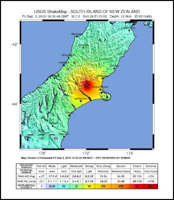
USGS: Magnitude 7.0 - SOUTH ISLAND OF NEW ZEALAND
Magnitude 7.0 - SOUTH ISLAND OF NEW ZEALAND
2010 September 03 16:35:46 UTC
Earthquake Details
This event has been reviewed by a
seismologist.
Magnitude
7.0
Date-Time
Friday,
September 03, 2010 at 16:35:46 UTC
Saturday, September
04, 2010 at 04:35:46 AM at epicenter
Time of Earthquake
in other Time Zones
Location
43.375°S,
172.016°E
Depth
12 km (7.5 miles) set by location
program
Region
SOUTH ISLAND OF NEW
ZEALAND
Distances
55 km (35 miles) WNW of
Christchurch, New Zealand
185 km (115 miles) S of
Westport, New Zealand
305 km (190 miles) NNE of Dunedin,
New Zealand
325 km (200 miles) SW of WELLINGTON, New
Zealand
Location Uncertainty
horizontal +/- 11.2 km
(7.0 miles); depth fixed by location
program
Parameters
NST= 98, Nph= 98, Dmin=86.7 km,
Rmss=1.69 sec, Gp= 32°,
M-type=teleseismic moment
magnitude (Mw), Version=8
Source
USGS NEIC
(WDCS-D)
Event ID
us2010atbj
Tectonic Summary
The September 3, 2010 South Island, New Zealand earthquake occurred as a result of strike-slip faulting within the crust of the Pacific plate, near the eastern foothills of the Southern Alps at the western edge of the Canterbury Plains. The earthquake struck approximately 50 km to the west-northwest of Christchurch, the largest population center in the region, and about 80-90 km to the south and east of the current expression of the Australia:Pacific plate boundary through the island (the Alpine and Hope Faults). The earthquake, though removed from the plate boundary itself, likely reflects right-lateral motion on one of a number of regional faults related to the overall relative motion of these plates and may be related to the overall southern propagation of the Marlborough fault system in recent geologic time.
Today's earthquake occurred approximately 50 km to the southeast of a M7.1, surface-rupturing event in Authur's Pass, on March 9th, 1929, which caused 17 fatalities. More recently, two earthquakes of M6.7 and M5.9 occurred in June 1994 approximately 40 km to the northwest of today's event, but did not cause any known fatalities or significant damage.

Click to enlarge
ENDS


 Greenpeace: Urgent Action Needed At SB62 As Amazon, Climate Slip Closer To Tipping Points
 UNICEF: Statement By UNICEF Executive Director On The Children Killed By The Alarming Escalation Of Violence In The Middle East
 Big Shift Global Campaign: The World Bank Is Making Bad Economic Decisions | U-Turning On Its Energy Policies
 UN Department of Global Communications: FAO Releases The Most Detailed Global Assessment Of Marine Fish Stocks To Date
 World Economic Forum: Gender Gap Closes At Fastest Rate Since Pandemic
 KidsRights: KidsRights Index 2025 Now Available