NASA Satellite Images & Detail Of Hurricane Rita
NASA Satellite Images & Detail Of Hurricane Rita

Click for big version
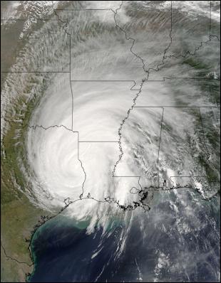
The MODIS instrument on the Terra satellite captured this image of Hurricane Rita as it made landfall on the Gulf Coast on September 24, 2005. Credit: NASA image courtesy Jeff Schmaltz, from the MODIS Rapid Response Team at NASA GSFC

Click for big version
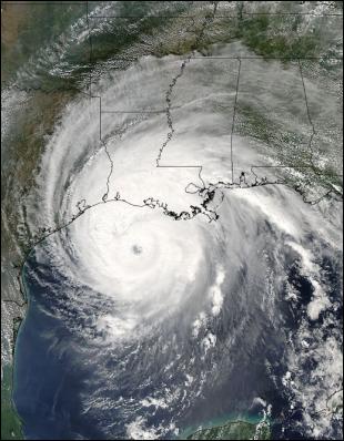
The MODIS instrument on the Aqua satellite captured this image of Hurricane Rita as it started making landfall on the Gulf Coast on September 23, 2005. Credit: NASA image courtesy Jeff Schmaltz, from the MODIS Rapid Response Team at NASA GSFC

Click for big version
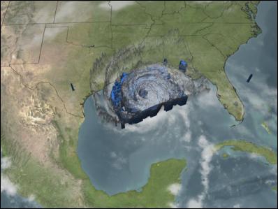
NASA's Tropical Rainfall Measuring Mission (TRMM) spacecraft observed this view of Hurricane Rita on September 23, 2005 at 12:52 pm EDT. At this time the storm was a category 4 hurricane with a minimum pressure of 924 mb, and sustained winds of 120 knots. The cloud cover is taken by TRMM's Visible and Infrared Scanner(VIRS) and the GOES spacecraft. The rain structure is taken by TRMM's Tropical Microwave Imager (TMI). It looks underneath of the storm's clouds to reveal the underlying rain structure. Blue represents areas with at least 0.25 inches of rain per hour. Green shows at least 0.5 inches of rain per hour. Yellow is at least 1.0 inches of rain and red is at least 2.0 inches of rain per hour. Click on image to view animation (no audio - 9.7 b) Credit: NASA

Click for big version
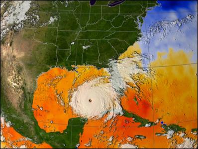
This visualization shows the sea surface temperature from September 17 to September 21 when temperatures in the Gulf of Mexico remained one to two degrees warmer than the 82 degree minimum needed to sustain a hurricane. Every area in yellow, orange or red represents 82 degrees F or above. Temperature data is from the AMSR-E instrument on the Aqua satellite, while the cloud images of Hurricane Rita were taken by the Imager on the GOES-12 satellite. Click on image above to view animation (no audio - 3.7 Mb.) Credit: NASA


 COP29: Navigating Ocean Finance - Investing In A Sustainable Blue Future
 Global Strategic Communications Council: One Year After Signing The Tripling Pledge, Governments’ Targets Are Unchanged, Even As Solar’s Prospects Are Upgraded
 UN Climate Change: Financing The Future - Vera Songwe’s Vision For A Climate And Growth Agenda At COP29
 Glasgow Actions: At COP29, Global Activists Urge Strong Climate Finance Deal By Transforming Baku's Olympic Stadium Into Call For Action
 Climate Action Network: COP29 - Repression Epidemic Regarding Climate Activists And Human Rights Defenders
 Demand Climate Justice DCJ: Climate Justice Groups Condemn COP29’s Carbon Markets Decision - Corporate Profits vs People’s Interests