Wet weather continues for the north

New Zealand has had an interesting weather week, with rain, winds and snow all making an appearance with noticeable flare for many across the country. MetService says there’s more to come through the coming weekend.
Those in parts of the South Island woke up to a winter wonderland on Thursday, after a push of cold air overnight left a blanket of snow over Otago, Canterbury High Country, and the Southern Lakes, with snow even settling at lake level in Wanaka, a height of around 350 metres.
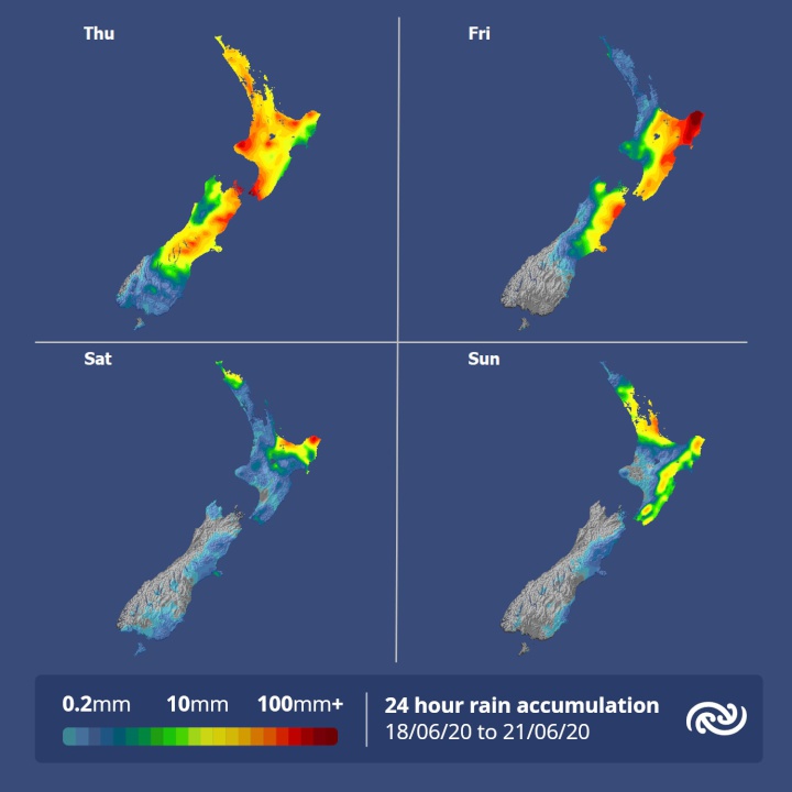
Wellington, which has been clouded over with rain since the start of the week, has a Heavy Rain Warning in effect for Thursday. MetService meteorologist Mmathapelo Makgabutlane elaborates: “More than 30mm of rain fell during the first half of the day across the region, and more rain is expected for the rest of the day.”
The focus switches to the upper and eastern North Island over the coming days, as a low pressure system currently just west of the country gradually makes its way around the top of the North Island. This system draws warm, moist air from the sub-tropics over the island and brings rain to many. “The resulting northeasterly winds set up a rain pattern that sees parts of Bay of Plenty and the Gisborne ranges get heavy rain; some places, particularly those in the mountains, could get around 130 to 180mm between today and Saturday,” Makgabutlane explains.
As winds turn easterly the activity spreads to those regions with a north to south coastline. Coromandel, western Bay of Plenty, Gisborne, and Hawke's Bay could all see some decent rainfall numbers by the end of the weekend. “People are advised to continue keeping an eye on the latest severe weather information,” says Makgabutlane.
Scattered rain is on the cards for much of the remainder of the North Island at times this weekend, which might not bode well for Wellington rugby fans. Those in the Waikato, however, may have better luck, with a lower likelihood of a wet Saturday afternoon.
Things are looking much quieter on the other half of the country. “The east and southern coastal areas could still see a shower or two, but all-in-all, the South Island can expect a quieter weather weekend,” Makgabutlane says.
Understanding our Severe Weather Watches and Warnings
Outlooks are about looking ahead:
• To
provide advanced information on possible future Watches
and/or Warnings
• Issued routinely once or twice a
day
• Recommendation: Plan
Watches are about being
alert:
• When severe weather is possible, but not
sufficiently imminent or certain for a warning to be
issued
• Typically issued 1 - 3 days in advance of
potential severe weather.
• During a Watch: Stay
alert
Orange Warnings are about taking
action:
• When severe weather is imminent or is
occurring
• Typically issued 1 - 3 days in advance of
potential severe weather
• In the event of an Orange
Warning: Take action
Red Warnings are about taking
immediate action:
• When extremely severe weather is
imminent or is occurring
• Issued when an event is
expected to be among the worst that we get – it will have
significant impact and it is possible that a lot of people
will be affected
• In the event of a Red Warning: Act
now!


 SolarZero: SolarZero Limited (in Liquidation) - Important Business Update
 Science Media Centre: Cyclone Gabrielle's Impacts On NZ's Ecosystems - Expert Reaction
 RNZ: Parts Of Power System Could Be Out For 36 Hours In Event Of Extreme Solar Storm
 NZAS: New Zealand Association Of Scientists Awards Celebrate The Achievements Of Scientists And Our Science System
 Stats NZ: Retail Spending Flat In The September 2024 Quarter
 Antarctica New Zealand: International Team Launch Second Attempt To Drill Deep For Antarctic Climate Clues


