 Scoop has an Ethical Paywall


Outlook for the weekend and into Monday
MetService News Release
14/11/19
Outlook for the weekend and into Monday
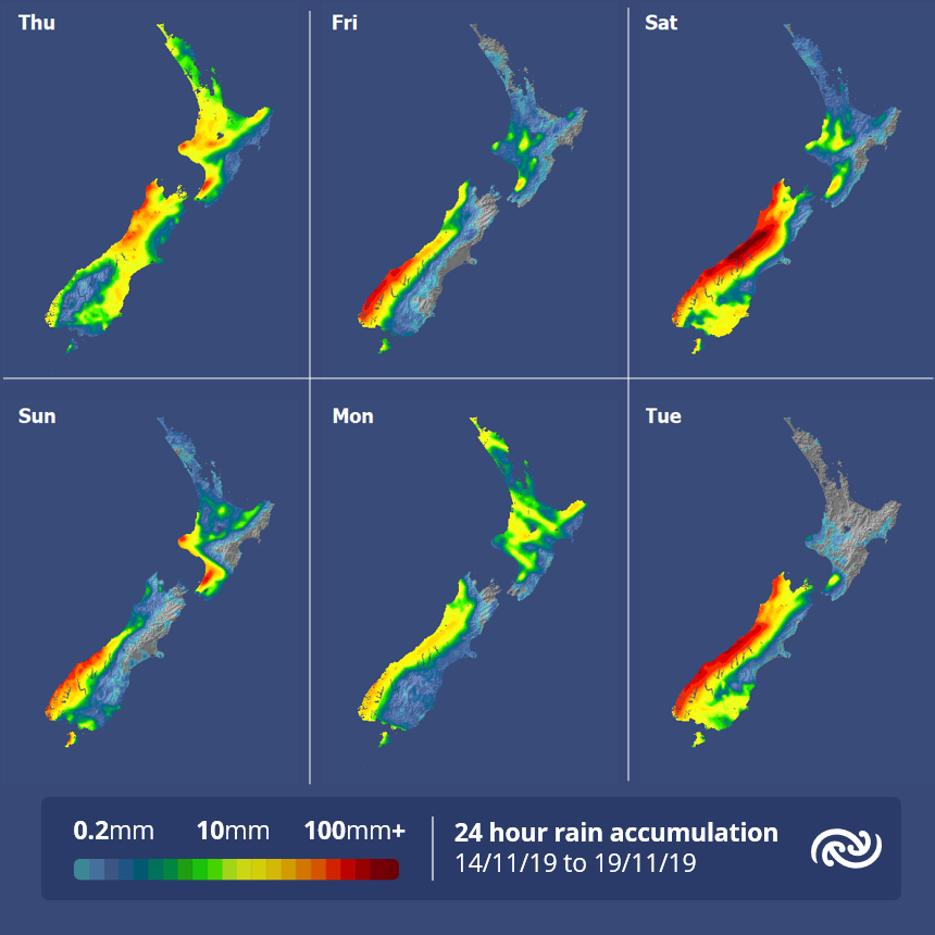
MetService is forecasting a wet and windy weekend for parts of Aotearoa but it isn’t all doom and gloom as with some planning there will be opportunities to enjoy the outdoors.
As an active front moved eastwards across the North Island early this morning, it brought a band of rain and a considerable number of lightning strikes.
Meteorologist Andy Best comments, “Since 11pm last night, 5625 lightning strikes were detected, mostly over New Zealand waters, with just 308 strikes overland about the Northland District. The front brought rainfall rates of 10 to 25mm per hour at times as it swept over the Taranaki and Tasman districts in the early hours of this morning, and lesser amounts farther north. Strong west to northwest winds developed ahead of the front, with both Waiouru and Castlepoint recording gusts of 120km/h around 4am and Stephens Island in the Marlborough Sounds 128km/h at 6am this morning.”
“Later today, there is a risk of heavy showers and isolated thunderstorms popping up over eastern parts of the South Island South of about Kaikoura,” says Andy Best,
From Friday to Saturday, a series of fronts are expected to affect the South Island from the Tasman Sea, bringing heavy rain to places in the west of the island. MetService have already issued Heavy Rain Warnings (Orange) and Watches for this event.
“We expect westerly winds ahead of the fronts to dominate the weather during this period, possibly severe gale about Wellington, Wairarapa, Marlborough and the Canterbury High Country,” says Andy Best.
Westerly winds make for warm, mainly fine conditions for much of the east of the country on Saturday. Continuing warm Saturday night over much of the North Island, with temperatures around 4 degrees above average. Only a few showers are expected on Saturday, from Waitomo to the Kapiti Coast.
The fronts continue moving north, reaching the lower North Island around midday Sunday and Auckland around midday Monday. Temperatures will be around average over the country on Sunday and Monday although slightly above the norm in Hawkes Bay with the mercury rising to around 26 or 27 degrees in Napier and Hastings. West to northwest winds continue Sunday, but a brief, cool southwest change will spread up the country on Monday, prior to more unsettled weather for the west of the South Island expected on Tuesday.
 Commerce Commission: Systemic Breaches Of Consumer Law Lead To $1.5million Fine For Kiwibank
 SolarZero: SolarZero Limited (in Liquidation) - Important Business Update
 Science Media Centre: Cyclone Gabrielle's Impacts On NZ's Ecosystems - Expert Reaction
 RNZ: Parts Of Power System Could Be Out For 36 Hours In Event Of Extreme Solar Storm
 NZAS: New Zealand Association Of Scientists Awards Celebrate The Achievements Of Scientists And Our Science System
 Stats NZ: Retail Spending Flat In The September 2024 Quarter


