 Scoop has an Ethical Paywall


Tasman Low Keeps the Upper North Island Under a Cloud
MetService News Release
9
September 2019
Tasman Low Keeps the Upper North Island Under a Cloud of Wet Weather
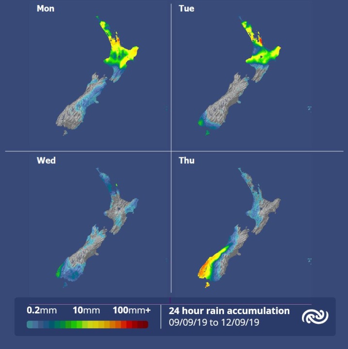
A low over the Tasman Sea will continue the trend of unsettled weather for the upper North Island with thundery showers or rain forecast for most areas north of the Central Plateau today and tomorrow, according to MetService.
MetService meteorologist April Clark says, “Although some good fine breaks will be seen over the upper North Island this morning, these glimpses of the sun will be interjected with heavy and possibly thundery showers. Showers will turn to persistent rain for the western Bay of Plenty, who are under a Heavy Rain Watch, and the Coromandel, who have an Orange Warning due to a slow moving front over the area.”
The rest of the country, excluding the far south, will see drier conditions today and Tuesday as showers currently over eastern coasts are already easing. However, the cooler temperatures seen over the weekend are set to stick around for much of this week as a cold front, which moves over the country from late Tuesday, brings in a new wave of cold air and period of rain for the south of the South Island.
“The upper North Island begins to head into a drier regime from Wednesday as the low from the Tasman moves off to the east, though a few showers will linger. The southwesterly winds behind the low will see overnight temperatures drop to below average in northern areas – much like the rest of the country, ” Clark comments.
Another front is forecast to approach the South Island on Thursday, bringing strong northwesterlies ahead of it. This signals a change to wet weather for the west of the South Island and a warm shift for eastern regions with Dunedin City forecast to have a maximum temperature of 18C ahead of the front on Thursday - 10C higher than at the start of this week.
 Vegetables New Zealand: New Web-Based Tool Will Help Greenhouse Growers Switch To Geothermal Heating
 Horizon Research Limited: New Poll - New Zealanders Prefer Rail Enabled Ferries
 Watercare: Watercare Gets To Work On First Permanent Non-Potable Water Tanker Filling Station In Māngere
 Alcohol Healthwatch: Licensing Decision Lauded For Prohibiting Buy Now Pay Later Schemes In Bottle Stores
 Motor Industry Association: Vehicle Registrations Up 5.6% In December, But Year-To-Date Sales Reflect Market Challenges
 BNZ: Depression-era Bequest Still Helping 88 Years Later


