 Scoop has an Ethical Paywall


Thunderstorms And Gusty Winds Batter the North
MetService News
Release
22/08/19
THUNDERSTORMS
AND GUSTY WINDS BATTER THE NORTH
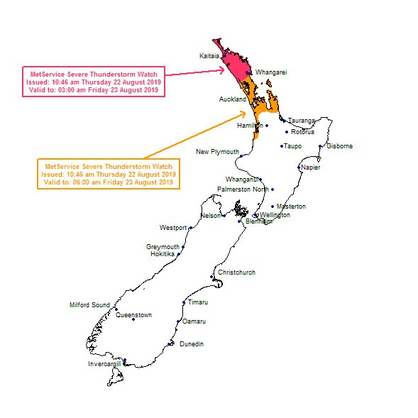
MetService has issued a Severe Thunderstorm Watch for northern areas of the North Island tonight into Friday morning.
MetService
meteorologist Lewis Ferris warns: “There could be very
strong localised wind gusts over 110 km/h from the northwest
and we are advising residents in affected areas to tie down
objects that could be caught by the wind overnight. There
is also a possibility of tornadoes developing with the
severe thunderstorm cells.”
A
complex low-pressure system is rolling over the country
today (Thursday) and tomorrow which brings heavy rain,
squally thunderstorms, strong winds and possible tornadoes
to northern areas of the North Island and subsequent Severe
Weather Watches have been issued. The South Island is not
spared from thunderstorm activity with the West Coast being
at risk until Friday evening.
On Friday the flow turns southwesterly over the country, which eases the heavy rain around the North Island in the evening and we see a general clearing trend which sets most places up for an enjoyable weekend.
The southwesterlies are persistent through the weekend and could be strong at times but generally most places will be in for a relatively dry couple of days. However, a few pesky showers will linger around western areas of the North Island, while showers turn to rain for Westland and Buller through the weekend.
 Commerce Commission: Systemic Breaches Of Consumer Law Lead To $1.5million Fine For Kiwibank
 SolarZero: SolarZero Limited (in Liquidation) - Important Business Update
 Science Media Centre: Cyclone Gabrielle's Impacts On NZ's Ecosystems - Expert Reaction
 RNZ: Parts Of Power System Could Be Out For 36 Hours In Event Of Extreme Solar Storm
 NZAS: New Zealand Association Of Scientists Awards Celebrate The Achievements Of Scientists And Our Science System
 Stats NZ: Retail Spending Flat In The September 2024 Quarter


