 Scoop has an Ethical Paywall


Mobile fronts make for changeable conditions this weekend
MetService News Release
11 July
2019
Mobile fronts make for changeable
conditions this weekend
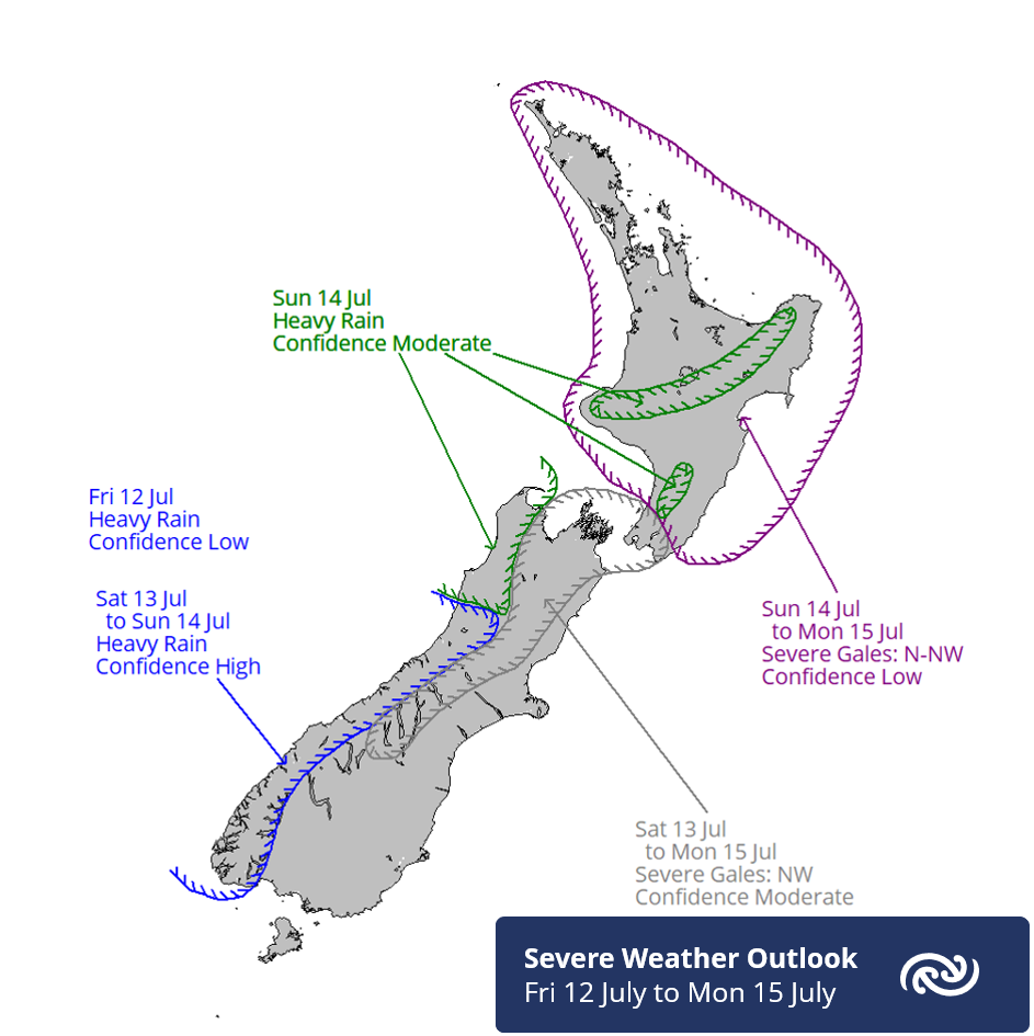
A series of fronts are forecast to move across the country from the west on Friday and over the weekend, delivering periods of rain and blustery north to northwesterly winds at times across much of the country.
MetService meteorologist Andy Best comments, “The flow stays predominantly northwesterly ahead of these fronts, bringing warm, air over much of the North Island from the tropics. Temperatures over much of central and northern New Zealand during the nights ahead are expected to around 8 degrees above average for this time of year. In addition to the warm nights, expect conditions to be uncomfortably muggy, especially from about Taupo northwards.”
These fronts bring a high confidence of heavy rain during Saturday and Sunday to Westland and Fiordland, with a moderate confidence over Buller, northwest Nelson, the Tararua Range, and higher parts of the central North Island from Mount Taranaki, across the central plateau and further east to the ranges of eastern Bay of Plenty.
MetService forecasters have already issued a Severe Weather Watch for a period of heavy rain through to Friday, but further Watches and/or Warnings are expected to be issued in the next 24hrs and people are advised to visit metservice.com/warnings/home for current and future warnings.
Eastern parts of the North Island see very little rain ahead over the weekend, only scattered falls from Saturday afternoon. Eastern parts of the South Island should stay dry Friday and Saturday, but a southwest change on Sunday brings the prospect of showers.
Strong northwest winds are another feature of these frontal systems, with a moderate risk of northwesterlies becoming severe at times, from late Saturday through into Monday in parts of the Canterbury High Country, inland Marlborough including the Sounds, Wellington and southern Wairarapa.
For skiing enthusiasts, strong northwest winds aloft on Friday are not the best conditions to look forward to. However, with snow levels expected to be around 1200-1400m over the lower South Island Friday and Saturday, then lowering further during Sunday, some ski areas should receive some welcome snow over the coming days with winds easing on Sunday. To see how your favourite slopes are shaping up, go to metservice.com/skifields for the latest snow level and wind forecasts.
 Commerce Commission: Systemic Breaches Of Consumer Law Lead To $1.5million Fine For Kiwibank
 SolarZero: SolarZero Limited (in Liquidation) - Important Business Update
 Science Media Centre: Cyclone Gabrielle's Impacts On NZ's Ecosystems - Expert Reaction
 RNZ: Parts Of Power System Could Be Out For 36 Hours In Event Of Extreme Solar Storm
 NZAS: New Zealand Association Of Scientists Awards Celebrate The Achievements Of Scientists And Our Science System
 Stats NZ: Retail Spending Flat In The September 2024 Quarter


