Atmospheric river hits NZ

An atmospheric river spanned from the Indian Ocean to New Zealand on Thursday, leading to huge rainfall totals along the West Coast and Southern Alps, according to NIWA meteorologist Ben Noll.
Atmospheric rivers are long, narrow regions in the atmosphere – like rivers in the sky – that transport most of the water vapour outside of the tropics in this case toward New Zealand.
Mr Noll said the “river” was influenced by an active pulse in the Madden-Julian Oscillation - a pulse of cloud and rainfall in the tropics that contributes to extreme weather events on a global scale.
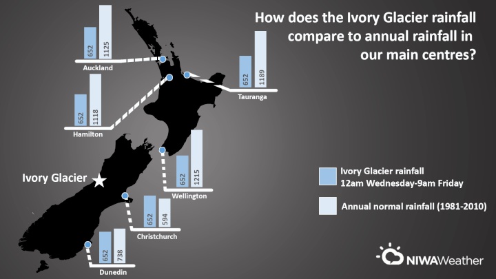
Ivory Glacier on the West Coast received the most rain between 12am on Wedensday and 9am today, with 652mm falling there. That is more rain than Christchurch receives each year.
Top rainfall total (12am Wed-9am Fri):
Ivory Glacier (1390m): 652 mm
Ivory Glacier rainfall total as a % of annual normal rainfall for the main centres:
-Christchurch
(Airport): 110% (annual normal rainfall: 594 mm)
-Dunedin
(Musselburgh): 88% (annual normal rainfall: 738
mm)
-Hamilton (Ruakura): 58% (annual normal rainfall:
1118 mm)
-Auckland (Mangere): 58% (annual normal
rainfall: 1125 mm)
-Tauranga (Airport): 55% (annual
normal rainfall: 1189 mm)
-Wellington (Kelburn): 54%
(annual normal rainfall 1215 mm)
Other totals (12am Wed-11am Fri):
High
elevation
Mt Philistine: 508
mm
Arthurs Pass: 397 mm
Mt Cook: 351 mm
Low elevation
Greymouth:
121 mm
Hokitika: 121 mm
Westport: 69
mm
The next few weeks see frequent high pressure systems affecting New Zealand, with rainfall that is normal or below normal for most of the South Island. Parts of the North Island, however, may contend with a few bouts of heavy rainfall before the end of November. Temperatures are expected to run average or above average with another very warm spell coming for eastern areas later next week.
ends


 Hugh Grant: How To Reduce Network Bottlenecks
 Dominion Road Business Association: Auckland Transport's 'Bus To The Mall' Campaign: A Misuse Of Public Funds And A Blow To Local Businesses
 Parrot Analytics: A Very Parrot Analytics Christmas, 2024 Edition
 Financial Markets Authority: Individual Pleads Guilty To Insider Trading Charges
 Great Journeys New Zealand: Travel Down Memory Lane With The Return Of The Southerner
 WorkSafe NZ: Overhead Power Lines Spark Safety Call


