 Scoop has an Ethical Paywall


Busy Weather Week Ahead
MetService News Release
13 August 2018
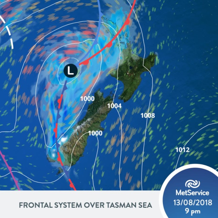
BUSY WEATHER WEEK AHEAD
MetService is forecasting a busy week of wet and windy weather for most areas of the country thanks to a low with several embedded fronts approaching from the west, however coastal eastern areas of the North Island should avoid the worst of the weather and remain mainly fine today.
“Heavy Rain Watches have been issued for many areas due to an active front, ahead of the low,” MetService meteorologist Mark Bowe says, “A moderate risk of thunderstorms, possibly squally, has been issued for Monday evening for Northland and Auckland. Auckland is also expecting king tides tonight and again tomorrow morning. However eastern areas of the South Island will remain mostly fine and dry today.”
As the rain band moves east across the top of the country overnight it will bring a period of heavy rain from Northland to northern Gisborne, including Auckland and Bay of Plenty and this is reflected in the current Severe Weather Watches.
On Tuesday, a low moves over the North Island, bringing strong west to southwest winds and another period of rain and possible thunderstorms to some regions.
“The winds are expected to pick up to gale and may approach severe gale in exposed places for Northland, Auckland including Great Barrier Island, Coromandel Peninsula, Waikato and the Bay of Plenty regions Tuesday evening,” says Bowe, “A Strong Wind Watch has been issued for these areas.”
The South Island doesn’t escape the wet weather during Tuesday with scattered rain becoming widespread for the lower parts of the Island.
Wednesday will see showery south westerlies for the North Island and a brief ridge of high pressure builds over the South Island. Most parts of the South Island will take a break from the wet weather on Wednesday with the showers over the North Island easing in the evening.
North-westerly winds pick up over the lower South Island early on Thursday ahead of another frontal feature approaching from the Tasman Sea. This active feature will bring rain and possibly heavy falls to western areas as the front moves north.
 Commerce Commission: Systemic Breaches Of Consumer Law Lead To $1.5million Fine For Kiwibank
 SolarZero: SolarZero Limited (in Liquidation) - Important Business Update
 Science Media Centre: Cyclone Gabrielle's Impacts On NZ's Ecosystems - Expert Reaction
 RNZ: Parts Of Power System Could Be Out For 36 Hours In Event Of Extreme Solar Storm
 NZAS: New Zealand Association Of Scientists Awards Celebrate The Achievements Of Scientists And Our Science System
 Stats NZ: Retail Spending Flat In The September 2024 Quarter


