 Scoop has an Ethical Paywall


No One Escapes the Cold Blast
MetService News Release
9 April 2018
No One Escapes the Cold Blast
A complex low about to cross central New Zealand will spare no one from the cold air it will drag up from the Southern Ocean.
“On the back of a warmer than average summer this low will guarantee a noticeable decrease in temperature for all New Zealand, if not an unusually early dump of snow,” said April Clark MetService Meteorologist.
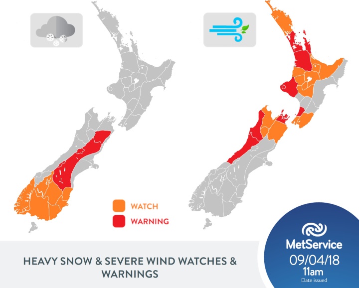
Severe Weather Watches and Warnings associated with this front have now been issued. Wind gusts of up to 140km/h and significant snow down to 400 metres is forecast over parts of the country from late this evening. The wind and snow are likely to cause disruption on roads and damage to power lines and unsecured structures. People are encouraged to check the latest watches and warnings to see whether they are likely to be affected when making plans into tomorrow. You can find all this information here http://info.metraweather.com/e/60812/AllWarnings/fsfx49/687900972.
“Southerlies strengthen over the South Island late today signalling the quick descent into the sub-Antarctic air mass,” Clark said. “This cold air paired with persistent rain developing over the mid to upper South Island tonight means snow levels are expected lower to 400 metres for inland areas of the South Island by early Tuesday morning,” she continued.
The largest snow accumulations are expected over east of the South Island (away from the coast) on Wednesday, though snow showers could penetrate as low as 300 metres south of Otago. Further north, the central North Island is forecast see snow down to 700 metres by Wednesday as the cold air forces north with the southerly change.
Thunderstorms with damaging gusts of up to 110km/h are forecast ahead of the low for many regions north of Buller from late tonight and into Tuesday. Areas under a moderate risk of severe thunderstorms are highlighted here http://info.metraweather.com/e/60812/STSWatch/fsfx4c/687900972.
Behind the low, strong southerly winds will also affect several regions including Auckland which will see the strong, cold turn during Tuesday evening. “Aucklanders see a windy Tuesday, with the worst of the wind expected after dark” Clark commented.
“As the low moves away to the east on Wednesday conditions are expected to ease and skies clear in the south. This means perfect condition for sub-zero temperatures for inland areas, this could be the hardest frost for inland South Island so far this year” warned Clark.
Once this system exits to the east of the country, another weather system is signalled for the latter part of the working week, bringing further unsettled weather.
Official Severe Weather Watches and Warnings are reviewed and re-issued by MetService at least every twelve hours, and more often if necessary. To get the most up to date information on severe weather around the country, or any other forecasts, see metservice.com or on mobile devices at m.metservice.com. You can also follow our updates on MetService TV, at MetService New Zealand on Facebook, @metservice and @MetServiceWARN on Twitter and at blog.metservice.com
ends
 Raise Communications: NZ Careers Expo Kicks Off National Tour Amid Record Unemployment
 Hugh Grant: How To Build Confidence In The Data You Collect
 Tourism Industry Aotearoa: TRENZ 2026 Set To Rediscover Auckland As It Farewells Rotorua - The Birthplace Of Tourism
 NIWA: Students Representing New Zealand At The ‘Olympics Of Science Fairs’ Forging Pathway For International Recognition
 Coalition to End Big Dairy: Activists Protest NZ National Dairy Industry Awards Again
 Infoblox: Dancing With Scammers - The Telegram Tango Investigation