 Scoop has an Ethical Paywall


NIWA's Hotspot Watch 9 February 2018
Friday, 9 February 2018
NIWA's Hotspot
Watch
A weekly update describing soil moisture across the country to help assess whether severely to extremely dry conditions are occurring or imminent. Regions experiencing these soil moisture deficits are deemed “hotspots”. Persistent hotspot regions have the potential to develop into drought.
Facts: Soil Moisture
Across the North Island, soil moisture levels have generally decreased in the southwest and increased in the north over the past week. The driest soils across the North Island compared to normal for this time of year are found in west coastal Taranaki, the Tararua District (Manawatu-Whanganui), and about Gisborne.
Hotspots in the North Island are located across Gisborne, the Tararua District, and in parts of west coastal Taranaki.
Across the South Island, soil moisture levels have generally remained the same over the past week except in Southland, where they increased slightly. The driest soils across the South Island compared to normal for this time of year are found in coastal Buller.
The only hotspot in the South Island is in Southland.
Outlook and Soil Moisture
Active weather is expected to be found across New Zealand this weekend, persisting across the North Island into early next week, before high pressure builds in and brings more settled conditions.
On Saturday, rainfall totalling 10 to 25 mm is expected in a band extending from western Northland into the Central Plateau. Across the lower and eastern North Island, 5 to 15 mm are forecast aside from Gisborne where totals less than 5 mm are likely.
Sunday will have another round of rain across the northern and western North Island, with 5 to 15 mm commonplace but localised amounts exceeding 25 mm. A narrow band of rain may persist from Monday into Tuesday, pivoting about the upper and western North Island. Each day, 10 to 20 mm is likely, although there may be areas of more persistent rains where totals exceed 25 mm.
From Wednesday into the late week, high pressure is likely to build across the island, yielding a return to drier conditions.
In the South Island, rain about the north on Saturday afternoon will total up to 5 mm and isolated showers in coastal Canterbury and Fiordland will total 5 mm or less. Sunday will have wet conditions, with the top of the island generally receiving 20 to 40 mm and a risk for localised flooding. Western areas will have a bit less, 15 to 35 mm, although sharply higher amounts up to 75 mm can be expected in the ranges. In the east, rainfall is expected to total 5 to 15 mm with 5 mm or less about the far south.
Wet conditions will prevail on Monday along the West Coast with another 10 to 25 mm expected. Rain is also possible in the north, with most places seeing 10 mm or less, especially in the west.
From Tuesday into Wednesday, rainfall chances about the South Island will generally decrease as weak high pressure builds overhead. Scattered rain cannot be ruled out, although totals will mostly be 5 mm or less.
Late in the week, a front over the Tasman Sea may approach, bringing a return to some wet weather in the west.
Over the next week, rainfall is expected to be above or much above normal in the North Island. Therefore, current hotspots are expected to shrink or be eliminated. In the South Island, normal or above normal rainfall is expected in the west, north and east. Normal or below normal rainfall is possible in the far south, which may allow the hotspot in Southland to persist.
Background:
Hotspot Watch a weekly advisory service for New Zealand media. It provides soil moisture and precipitation measurements around the country to help assess whether extremely dry conditions are imminent.
Soil moisture deficit: the amount of water needed to bring the soil moisture content back to field capacity, which is the maximum amount of water the soil can hold.
Soil moisture anomaly: the difference between the historical normal soil moisture deficit (or surplus) for a given time of year and actual soil moisture deficits.
Definitions: “Extremely” and “severely” dry soils are based on a combination of the current soil moisture status and the difference from normal soil moisture (see soil moisture maps at https://www.niwa.co.nz/climate/nz-drought-monitor/droughtindicatormaps)
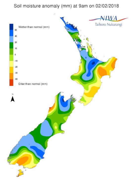
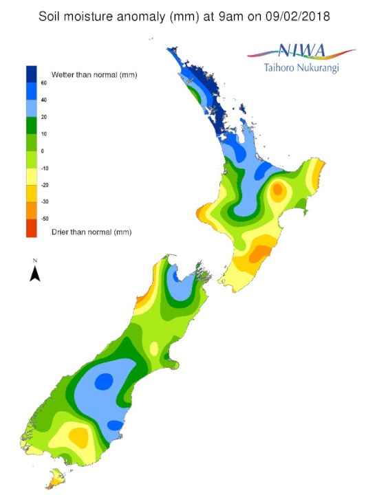
Pictured above: Soil Moisture Anomaly Maps, relative to this time of year. The maps show soil moisture anomaly for the past two weeks.
 Parrot Analytics: Paramount Earnings - Can Ellison Strike The Right Balance?
 NZ Trade and Enterprise: NZ Businesses Deliver $340 Million Trade Boost For New Zealand In China
 Ngā Manu Nature Reserve: Celebrating The Return Of Tuatara To Ngāti Koata And Brook Waimārama Sanctuary
 Employers & Manufacturers Association: Work-related Injuries In Manufacturing Create $1.23 Billion Economic Burden On NZ
 Consumer NZ: Consumer NZ Questions Supermarket Specials: Are They Really Saving You Money?
 NIWA: October Climate Summary - A Mild Month Overall, Very Wet For Much Of The South Island


