Rinse and repeat
MetService News Release
27 November 2017
Rinse and repeat

A static weather pattern over New Zealand sees the forecasts for the coming week similar for several consecutive days.
"Settled conditions remain for many places under a persistent ridge of high pressure, with little change from day to day. However, warm temperatures, sea breezes and humidity combine to form thunderstorms during the afternoons and evenings for inland areas of both the North and South Islands," said MetService Meteorologist Hannah Moes.
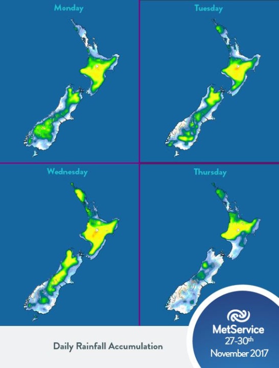
"When we look at accumulated daily rainfall, the pattern is apparent. Coastal areas remain mainly dry, while inland areas are targeted by showers and thunderstorms," Moes said, "the pattern is similar for each day this week".
In addition to lightning, other risks associated with thunderstorms can include heavy or torrential downpours and hail. With light winds across the country, storms that do form this week are unlikely to travel far and so rainfall accumulations in localised spots could be very high, bringing risks of flash flooding. The effects of thunderstorms can also reach areas away from the main action in the form of rapidly rising rivers and streams when a downpour has affected the catchment upstream.
There is some respite from the showers in sight for the lower south in the second half of the week, with the conditions stabilising there from Thursday.
Temperatures remain
warm across the country with some inland centres in the
South Island, like Wanaka and Reefton, expected to see
heatwave like conditions for five consecutive days. A more
detailed description of a heatwave is available on our blog
http://info.metraweather.com/e/60812/heatwave/fj4ytr/634998054.
While our temperatures this week are unlikely to break New
Zealand records for this time of year, the persistent warmth
is notable.
Forecast daily rainfall accumulations
for 27-30th November 2017.
To get the most up to date information on severe weather around the country, or any other forecasts, see metservice.com or on mobile devices at m.metservice.com. You can also follow our updates on MetService TV, at MetService New Zealand on Facebook, @metservice and @MetServiceWARN on Twitter and at blog.metservice.com
Official Severe Weather Watches and Warnings are reviewed and re-issued by MetService at least every twelve hours, and more often if necessary. To get the most up to date information on severe weather around the country, or any other forecasts, see metservice.com or on mobile devices at m.metservice.com. You can also follow our updates on MetService TV, at MetService New Zealand on Facebook, @metservice and @MetServiceWARN on Twitter and at blog.metservice.com
ends


 ERANZ: Electricity Saving Coaching Service To Launch In Wairoa
 SolarZero Affected Staff: SolarZero Staff Are Demanding Answers After The Company Went Into Liquidation
 Tātau Tātau O Te Wairoa: Guidance To Save Local Newspapers Amid NZME Closures
 Commerce Commission: Systemic Breaches Of Consumer Law Lead To $1.5million Fine For Kiwibank
 SolarZero: SolarZero Limited (in Liquidation) - Important Business Update
 Science Media Centre: Cyclone Gabrielle's Impacts On NZ's Ecosystems - Expert Reaction


