Rapidly Deepening Low’s Course Set for New Zealand
MetService News Release
6 November 2017
RAPIDLY DEEPENING LOW’S COURSE SET FOR NEW ZEALAND
As a ridge of high pressure builds across the country today, bringing relatively settled weather, a low currently over eastern Australia is getting ready to make a rapid break across the Tasman.
“This low will significantly deepen before it is expected to make landfall on the lower South Island late Tuesday,” said MetService Meteorologist April Clark.
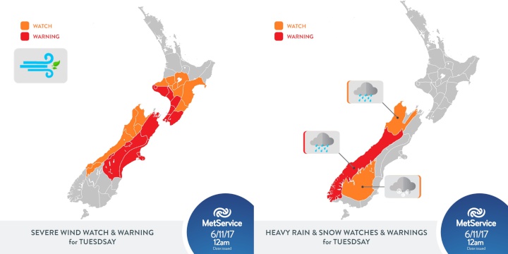
This means that weather conditions across the country will turn quickly on Tuesday, with much of the country starting off fine. However, as the afternoon and evening progresses rain is forecast to set in over the west and lower South Island. Heavy rain warnings and watches have already been issued for large rain accumulations over the west of the South Island.
As the low draws near, north to northwest winds also strengthen and gusts of up to 130km/h are possible in exposed places south of Wellington.
The low is predicted to move over the country overnight Tuesday, helping to drag cold air from the south into Otago and turning rain to snow above 400 metres, with significant accumulations possible above 600 metres from late Tuesday evening to early Wednesday morning.
The combination of strong winds and snow at higher levels has the potential to bring disruptions to affected areas as trees, now in full spring leafage, and power lines could suffer damage. Those driving over higher passes should make sure they keep up to date with road snow warnings and road status updates from NZ Transport Agency and local councils. Those thinking about travelling on foot in the mountain regions should consider postponing their plans until the weather event and its impacts have passed.
During Wednesday morning, the North Island is forecast to receive a heavy burst of rain from a front associated with the low. This top-up of rain may particularly impact areas from the Waikato up to Northland, where soil is already saturated. These areas may be added to Severe Weather Watches and Warnings as the event progresses, so it will be important for the public to keep up to date with the latest forecasts.
Much of the South Island and lower North Island will be impacted by strong to gale northerlies which are expected ahead of the front.
“This is a highly mobile, dynamic low which has the potential to drop temperatures, increase winds to severe gale force and bring heavy rain and snow to some places - all within a single afternoon,” said Clark.
“Fortunately, the low quickly moves off to the east later on Wednesday, taking the worst of the weather with it,” added Clark.


 ERANZ: Electricity Saving Coaching Service To Launch In Wairoa
 SolarZero Affected Staff: SolarZero Staff Are Demanding Answers After The Company Went Into Liquidation
 Tātau Tātau O Te Wairoa: Guidance To Save Local Newspapers Amid NZME Closures
 Commerce Commission: Systemic Breaches Of Consumer Law Lead To $1.5million Fine For Kiwibank
 SolarZero: SolarZero Limited (in Liquidation) - Important Business Update
 Science Media Centre: Cyclone Gabrielle's Impacts On NZ's Ecosystems - Expert Reaction


