Settled weather coming to an end this weekend
MetService News Release
5 October
2017
Settled weather coming to an end this weekend
After a spell of settled weather to start the school holidays, a low approaching from the Tasman Sea will bring it to an abrupt end, with wet weather expected for most during the weekend.
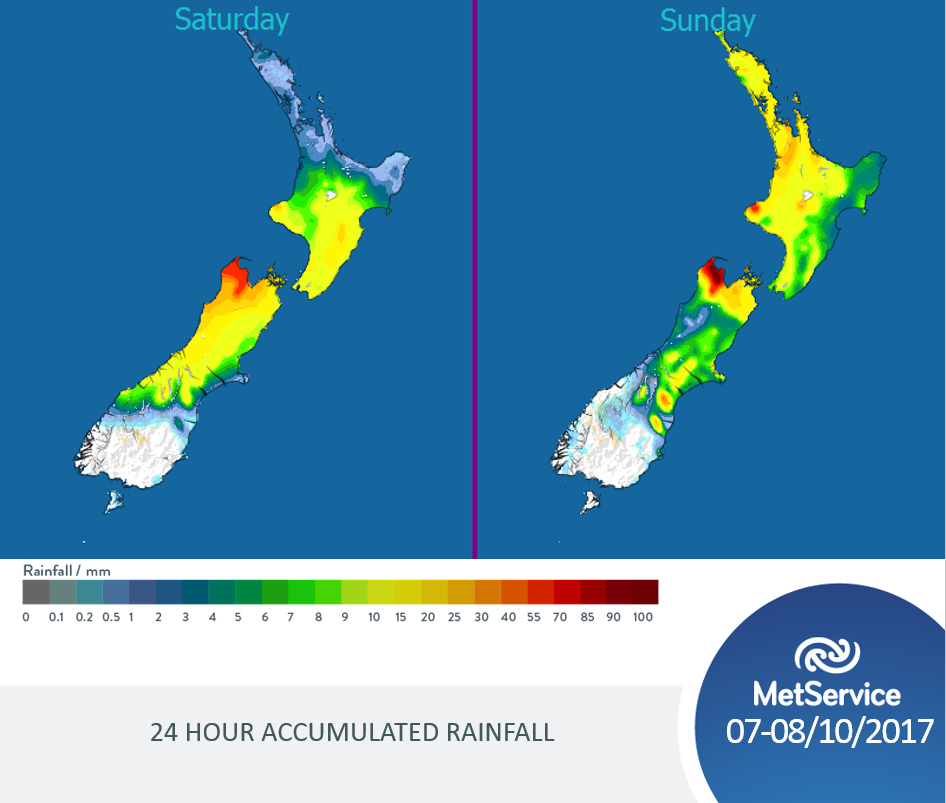
The low pressure system bringing the wet weather approaches the country from late tomorrow. The image below shows the accumulated rainfall forecast for Saturday and Sunday, with most of the North Island receiving wet weather in the form of bands of rain as the front spreads over New Zealand. The South Island will also experience wet weather but mostly in the central and northern areas, which will be exposed to the northerly winds expected with the frontal band. This leaves the far south dry which is probably the best place to be for the weekend.

The latest forecasts can be found at http://info.metraweather.com/e/60812/metservicenz/f49hrt/610684764
“The highest rain accumulations will be in the high lying regions exposed to the northerly flow, such as the Nelson Ranges, Mount Taranaki and the Tongariro National Park” explained Meteorologist Kyle Lee. “Also, the northerly winds associated with the front will bring some milder conditions to New Zealand. Generous minimum temperatures are expected for most of the main centres across the country, which are not expected to drop below double digits except in the far south and central Otago, with 13C expected for the likes of Auckland and Tauranga” continued Lee.
The trend for the start of next week is to remain unsettled for most which is also a good reminder to read up about the ‘Get Ready Week’ on the Civil Defence website http://info.metraweather.com/e/60812/blic-education-get-ready-week-/f49hrw/610684764.


 Stats NZ: Total Greenhouse Gas Emissions Fall 0.7 Percent In The September 2024 Quarter
 Takapuna Beach Business Association: Takapuna Outpaces Auckland With Strong Economic Growth In 2024
 Commerce Commission: Bed, Bath And Beyond Sentenced Over Record Number Of Unsafe Products
 GE Free NZ: Minister Reti Asked For Two Week Delay Of Select Committee Deadline
 Science Media Centre: Government Plans To Double Mineral Exports By 2035 – Expert Reaction
 University of Canterbury: AI-powered Tool To Combat Rising Wildfire Danger


