 Scoop has an Ethical Paywall


The weather: It’s Spring doing its thing
MetService News Release
7 September 2017
The weather: It’s Spring doing its thing
Thunderstorms, snow, gales, all interspersed with brilliant blue skies and warm temperatures. This weekend takes all the clichés of spring and delivers them across the country in a fast-paced smorgasbord of meteorological conditions.
“Strong westerly winds higher in the atmosphere are causing this extremely mobile weather,” explained meteorologist Tom Adams.
”On the ground, this can mean brilliant blue skies one minute then cloud and heavy rain the next. The most consistent thing this time of year is the wind, which will be strong in many places,” he added.
Thunderstorms are a regular component of spring weather. Last night 3,000 lightning strikes were recorded over and around New Zealand, waking people in the early hours in both Auckland and Wellington. Thunderstorms will continue today for western places, with a few also making it up the east coast of the South Island this afternoon.
Friday is a quieter day for thunderstorms, with most of the action confined to the West Coast, but thunder and lightning are likely to spread back across the country this weekend.
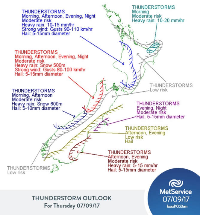
The thunderstorm outlook is issued daily and can be found at http://info.metraweather.com/e/60812/warnings-thunderstorm-outlook/dxbftn/595426331
Snow has also been falling in the ranges, especially those in the South Island. Adams went on to say, “The alternate route from Picton to Christchurch via Lewis Pass was closed this morning, and 2 to 4 centimetres more snow is expected to fall there today. Heading towards the weekend, freezing levels drop and more snow is expected to low levels for the west of the South Island. This is good news for the last weekend of the Queenstown winter festival.”
On Sunday, a strong southerly is forecast to move up the country, potentially bringing snow to the foothills of Otago, Canterbury and Marlborough.
Overall, most of the rain and snow will be in the west of both Islands, with lesser amounts making it across into the east. However, when the southerly kicks in later on Sunday the east is likely to see an increase in showers, as well as a drop in temperature. Early next week a brief ridge of high pressure will bring a day or two of calmer weather, before the weather dives back into more unsettled westerlies by mid-week.
ends
 ERANZ: Electricity Saving Coaching Service To Launch In Wairoa
 SolarZero Affected Staff: SolarZero Staff Are Demanding Answers After The Company Went Into Liquidation
 Tātau Tātau O Te Wairoa: Guidance To Save Local Newspapers Amid NZME Closures
 Commerce Commission: Systemic Breaches Of Consumer Law Lead To $1.5million Fine For Kiwibank
 SolarZero: SolarZero Limited (in Liquidation) - Important Business Update
 Science Media Centre: Cyclone Gabrielle's Impacts On NZ's Ecosystems - Expert Reaction


