So far, so very stormy
THURSDAY, JULY 13, 2017
So far, so very stormy

Today’s
low came spinning off the coast of Hawke’s Bay funneling
strong winds through the Cook Strait and hitting Wellington
region with strong winds before moving on to Taranaki and
Auckland this afternoon.
NIWA climate scientist
Nava Fedaeff has compiled this report of what’s happened
so far weather-wise:
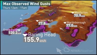
• At Baring Head, near Wellington, sustained 10 minute winds of 135.7 km were recorded between 8:40am and 8:50am – this is comparable to a Category 3 Tropical Cyclone.
• During that time at Baring Head the maximum wind gust recorded was 155.9 km/h. This was the 16th highest daily wind gusts recorded at this location since the station opened in 1991. The last time a stronger gust than this was recorded was June 12, 2006 so more than 11 years ago.
• The highest wind gust recorded at Baring Head was on the 12th of March 2010 when a gust of 216.8 km/h was recorded. On this day a strong southerly moved through and not unlike this event, caused widespread disruption including power outages, suspended rail services and damage. Insurance claims for that storm totaled $1.2million dollars.
• At Greta Point in Wellington a wind gust of 120.2 km/h was measured just after 7am today. This was the strongest wind gust since January 1.
• The calm before the storm: This storm comes following prolonged and unusually calm conditions in Wellington. During June there were just 6 days where winds gusts exceeded 33 knots (or 61.1 km/h) at Wellington Airport. The average for June is 13.7 days. Those stats put this June in third place for the LEAST windiest on record since records began in 1960. During July only 1 day exceeded this threshold up until Tuesday when the winds arrived!
• The NIWA wave buoy near Baring
Head was consistently recording a significant wave height
(highest 1/3 of waves) of more than six metres between 5am
and 8am. Observed maximum wave heights were in the 10m
range.
•
What’s to come?
Tomorrow strong southerly winds continue across the North Island but not of the same magnitude as today.
Maximum wind gusts for Wellington and Taranaki will be more in the 70-80km/h range – down from more than 110km/h.
Rain will continue across the lower North Island and Hawke's Bay tomorrow. Heavy rain will move from Wellington to Wairarapa and Hawke's Bay throughout the day before clearing offshore.
The weather clears in time for Saturday and the sun comes out. On Sunday a front will bring rain to the West Coast while the remainder of the country will continue to enjoy calm and settled weather.
ends


 Infrastructure New Zealand: Unlocking ‘Lazy’ Capital To Build New Infrastructure For Our Future
 Parrot Analytics: Paramount Earnings - Can Ellison Strike The Right Balance?
 NZ Trade and Enterprise: NZ Businesses Deliver $340 Million Trade Boost For New Zealand In China
 Ngā Manu Nature Reserve: Celebrating The Return Of Tuatara To Ngāti Koata And Brook Waimārama Sanctuary
 Employers & Manufacturers Association: Work-related Injuries In Manufacturing Create $1.23 Billion Economic Burden On NZ
 Consumer NZ: Consumer NZ Questions Supermarket Specials: Are They Really Saving You Money?


