 Scoop has an Ethical Paywall


Antarctic Air on the Way
MetService News Release
15 May 2017
ANTARCTIC AIR ON THE WAY
The warm air from the remnants of ex-Tropical Cyclone Donna last week will be a distant memory to New Zealanders by Friday, with strong southwesterlies delivering significantly chillier weather in the wake of a rain-laden low which moves over the country on Thursday.
Sunday’s settled weather is expected to break down by Wednesday, when the low, approaching from the west sends bands of rain over the country and northerly winds pick up. It is likely that Severe Weather Watches and Warnings will be issued closer to the time, with western coasts of the South Island and regions north of the North Island’s central Plateau expected to receive the largest rainfall amounts. You can check the Severe Weather Outlook and any Watches and Warnings here.
MetService meteorologist April Clark said, “As the low tracks east on Thursday, winds turn icy with the southwest change, and occasional showers are forecast to fall as snow to low levels over the lower South Island during Friday and Saturday. Those for whom snow doesn’t arrive will still be affected by the strong winds, which will make cold temperatures feel even more bitter. Gore’s forecast high for Friday sits at a wintry 8 degrees.”
Large waves accompany this weather system, with heavy northerly swell expected for the West Coast on Wednesday before a long period southwest swell spreads over New Zealand’s shoreline. Significant swell heights of 7-8 metres are expected along southern coasts of the South Island on Friday. You can check updated swell data on the marine forecast maps here.
With snow in the forecast down south, and eastern regions in the North Island set to see a double-digit drop in temperature, it will pay to have those winter coats handy this week!
You can keep up to date with forecasts as the situation evolves, at metservice.com
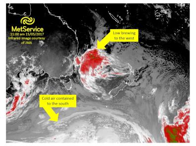
The satellite image above
shows the low expected to pass over the NZ on Thursday
developing to the west while Antarctic air remains contained
(for now) to the south.
Official Severe
Weather Watches and Warnings are reviewed and re-issued by
MetService at least every twelve hours, and more often if
necessary. To get the most up to date information on severe
weather around the country, or any other forecasts, see metservice.com or on mobile devices at
m.metservice.com. You can also follow
our updates on MetService TV, at MetService New Zealand on Facebook, @metservice and @MetServiceWARN on Twitter and at blog.metservice.com
 Plumbers Gasfitters and Drainlayers Board: Plumbers, Gasfitters And Drainlayers Board Drops ‘Journeyman’ And ‘Tradesman’ Names
 ERANZ: Electricity Saving Coaching Service To Launch In Wairoa
 SolarZero Affected Staff: SolarZero Staff Are Demanding Answers After The Company Went Into Liquidation
 Tātau Tātau O Te Wairoa: Guidance To Save Local Newspapers Amid NZME Closures
 Commerce Commission: Systemic Breaches Of Consumer Law Lead To $1.5million Fine For Kiwibank
 SolarZero: SolarZero Limited (in Liquidation) - Important Business Update


