 Scoop has an Ethical Paywall


Counting endangered birds from space
Counting endangered birds from space
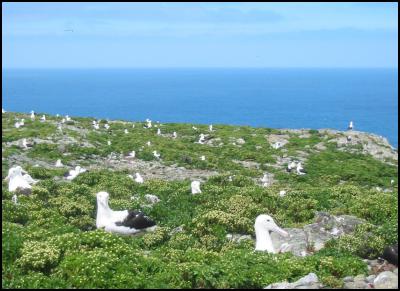
Image: Northern Royal
Albatross on the Chatham Islands. Credit: Canterbury
Museum
In a worldwide first, New Zealand and British scientists have used satellite images to calculate the number of endangered albatrosses living on remote and inaccessible islands.
Researchers from the British Antarctic Survey and Canterbury Museum have shown in a study published today that the highest resolution satellite imagery is capable of “seeing” these birds from space, allowing researchers to count them on remote islands without ever having to go there. The study used the new WorldView-3 satellite, which can see objects larger than 30 cm.
The team developed and tested the accuracy of the satellite-method by counting individuals on a well-studied colony of Wandering Albatross (Diomedea exulans) on South Georgia, a remote island south east of Argentina in the southern Atlantic Ocean. They then applied it to the Northern Royal Albatross (Diomedea sanfordi), a species that only breeds in New Zealand.
Manual counting on the ground is expensive. Using aircraft to take photographs is also expensive and counting birds in photos is very time-consuming. The authors compared manual and automated counting techniques and found that automated techniques can work well and that this might allow large populations to be counted very rapidly.
The population status of the Northern Royal Albatross on New Zealand’s Chatham Islands was poorly known due to the remoteness and limited accessibility of the breeding grounds. The study found that Northern Royal Albatross numbers are stable on one inaccessible island, but have declined dramatically on another island group.
“This is a major conservation concern for this globally-endangered albatross species,” said Professor Paul Scofield, Canterbury Museum’s Senior Curator Natural History and a co-author of the study. “This technique will be an invaluable global conservation resource that can give us near real time information about the status of endangered species.
“The ground-breaking image resolution of the newly-available satellite will provide a step change in our ability to count albatross, large birds and other wildlife directly from space without disturbance, at potentially lower cost and with minimal logistical effort.”
The study is published today in Ibis.
To cite this article: Peter T Fretwell, Paul Scofield & Richard A Phillips, 2017. Using super-high resolution satellite imagery to census threatened albatrosses. Ibis DOI: 10.1111/ibi.12482
ENDS
 Spirits New Zealand: A Year Of Two Halves For The NZ Spirits Industry
 MoneyHub: Comprehensive Guide To New Zealand Wage And Salary Distributions
 Blackland PR: New Zealand’s Sinking Feeling - 2024’s Toughest PR Challenges Revealed
 Zhenbo Wang, The Conversation: From New Commercial Moon Landers To Asteroid Investigations, Expect A Slate Of Exciting Space Missions In 2025
 Worldline: Boxing Day Spending Up On Last Year, But Pre-Christmas Spending Is Slightly Down
 Skoltech: Scientists Reinvent Physical Laws Governing Formation Of Snowflakes, Raindrops, And Saturn’s Rings


