 Scoop has an Ethical Paywall


Round up of this week’s weather
MetService News Release
14 April 2017
Round up of this week’s weather
This week we were visited by a low from the Tasman Sea closely followed by Cyclone Cook from the Tropics, bring rain and wind to already saturated regions of New Zealand.
One of the significant impacts this week was flooding due to excessive rainfall amounts. Rainfall amounts topped out at 350mm over the past 60 hours in parts of northwest Nelson, with 200mm+ measurements recorded about Coromandel Peninsula, and between 150-200mm in the Kaimai Ranges. Rainfall amounts of between 30-50mm were commonplace elsewhere. Surface flooding was widespread in many regions as the low from the Tasman Sea combined with a tropical air feeding down from Cyclone Cook. These rainfall accumulations exasperated issues in regions with already saturated, sodden ground.
Cyclone Cook brought strong winds; the strongest where located along the eastern side of the system as it moved down the country. Weather stations recorded wind gusts of:
· 209km/h at White Island,
· 100km/h Whakatane, before the weather station lost power just prior to Cyclone Cook making landfall.
· 90km/h reported at Tauranga
· Cape Kidnappers 154km/hr
· Castlepoint 114km/hr.
A significant number of trees were uprooted contributing to the widespread power outages and property damage.
Rain: between 150-200mm rain in 12
hours across Raukumara Range. Surface flooding, and swollen
rivers, along with slips which closed roads across parts of
the Coromandel Peninsula, Bay of Plenty, Gisborne and Hawkes
Bay.
Waves: Waves to 12.5 metres were recorded by the
regional councils wave buoy. Thankfully these waves occurred
about 3 hours before high tide, as there would likely have
been more damaging coastal inundation if Cyclone Cook passed
three hours later.
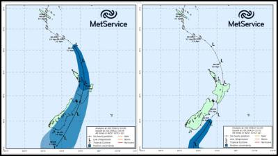
Figure 1. First storm track issued for Cyclone Cook on Tuesday. Figure 2. Observed storm track and current forecast track issued at 1pm Friday. (Black line shows track, while the blue cone is the spread of uncertainly associated with the track.)
First track (Figure 1) issued on Tuesday when Cyclone Cook moved into MetService area of responsibility versus actual recorded track plus forecast track for Friday afternoon and evening. (Figure 2). Although they may look very similar, if you look closely you can see that the actual track was slightly to the east of the forecast tract, and Cyclone Cook did not strengthen as quickly or as much as global weather models predicted. Cyclone Cook made landfall with a central pressure of 980hPa being recorded at Whakatane. Tropical cyclones can be notoriously difficult to forecast, both in intensity and exact track. In the case of Cyclone Cook, the overall track shifted slightly eastward in the hours before making landfall in the Bay of Plenty. Being such a compact system, Cyclone Cook had a limited swath of intense, damaging winds. Additionally, the cyclone did not intensify as deeply as the global and small-scale weather models predicted. Put together, the strongest winds remained east of Auckland, and instead significantly impacted the Bay of Plenty. Had the track not shifted, or if it had tracked slightly further west, Auckland would have seen winds comparable to what were measured at White Island, Whakatane or Cape Turnagain. While Auckland experienced a lucky escape from the cyclone, others in the Bay of Plenty, Gisborne and Hawkes Bay bore the brunt of the storm. Advanced warning of this event and its possible impacts enabled individuals to take the necessary precautions and prepare for the worst-case scenario. The safety of property, animals and loved ones is, and will continue to be, MetService’s first priority.
As Cyclone Cook moved southwards, it directed a southeasterly flow across the lower North Island. As Wellington is quite sheltered from this direction, the overall wind speeds remained relatively light (at 85km/h). However, northerlies pushed into the area Friday morning as Cook moved further south, and are now gusting 85km/h from that direction. And it’s important to keep in mind that Wellingtonians are well-versed when it comes to strong winds.
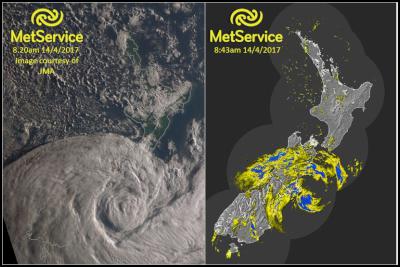
A visible satellite image and radar image showing Cyclone Cook off the coast of the South Island.
Christchurch experienced the tail end of Cyclone Cook. Rainfall amounts of 30-50mm were commonplace across Marlborough and Canterbury, with higher amounts across Banks Peninsula. There are reports of the Heathcote River spilling its banks, along with surface flooding in other places.
Lisa Murray, Communications Meteorologist and the media team at MetService.
Official Severe Weather Watches and Warnings are reviewed and re-issued by MetService at least every twelve hours, and more often if necessary. To get the most up to date information on severe weather around the country, or any other forecasts, see metservice.com or on mobile devices at m.metservice.com. You can also follow our updates on MetService TV, at MetService New Zealand on Facebook, @metservice and @MetServiceWARN on Twitter and at blog.metservice.com
 Antarctic Heritage Trust: NZ-made ‘Cutting-Edge’ VR Experience Tours The UK
 Brian Gaynor Business Journalism Initiative: Brian Gaynor Initiative Business Journalism Funding Award Moves To Rolling Applications
  Inland Revenue: Fifth Anniversary Of The SBC Loans - Time To Repay
 Te Runanga o Ngati Hinemanu: First Marae Based Fresh Water Testing Science Lab Grand Opening 16-17 May 2025
 Raise Communications: NZ Careers Expo Kicks Off National Tour Amid Record Unemployment
 Hugh Grant: How To Build Confidence In The Data You Collect