Library unearths the first geological map ever produced
University of Canterbury Library unearths the first geological map ever produced
April 21, 2015

The University of
Canterbury Library has found a precious copy of what is
globally acknowledged as the first geological map of any
country ever produced with connections to early
Canterbury.
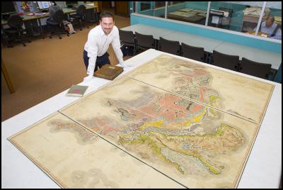
A copy of William Smith’s 200 year old geological map which is highly regarded as the first nationwide geological map of Britain is in special protection at the university library.
The map was popularised in Simon Winchester’s book The Map that Changed the World. Smith, known as the Father of English geology, was revered for his great achievement in 1815, the first geological map of England and Wales.
The map has been in the possession of the University Library for 96 years, and but its significance was only recently established while researching the Rare Books collection in the Macmillan Brown Library.
The items in library collections have been identified as important works at the time of purchase or donation but over time the significance of the work grows, they become rarer or more desirable to collectors, the university’s special collections librarian Damian Cairns says.
“Due to the misleading title on the case and the fact it looks like a book this item may have been overlooked for many years, sometimes it takes a little curiosity and luck to rediscover hidden gems.
“This is a very important and iconic work, which is very collectable and much sought after. It is a privilege to have in our collection and one of the real treasures of the University of Canterbury Library.
“Smith’s map is significant in its presentation of geology in a map form and the extension of earlier principles of geology to understand the concept of a fossil succession.
“The University of Canterbury’s copy has been identified by experts at the Geological Society of London as one of the early hand painted incarnations produced at the London office of publisher John Cary.
“We now know from the Geological Society’s records that this map numbered ‘b4’ was signed by Smith on the morning of Tuesday 23rd January 1816. Along with his highly skilled colourists John Cary produced, on behalf of Smith, approximately 350 copies of the map with as many as 120 to 150 surviving today, according to Tom Sharpe of the Geological Society.
Designed to look like a book, the case has two bookplates, one of Thomas Cuff, who has yet to be identified although there is an early settler to Canterbury of the same name, the other bookplate is a presentation acknowledgement from Robert Speight, who in 1919 was a Curator at Canterbury Museum and lecturer of Geology at Canterbury College (as the university was called then).
“Sir Joseph Banks (who Banks Peninsula is named after), to whom the map is dedicated to, was Smith’s major sponsor in the research and production of his work providing funds for Smith to complete the map.
“Plans are under way to have the map assessed by a conservation specialist and to explore digitisation options, enabling the map to be used in teaching in both arts and sciences courses at the university and to provide greater access to research possibilities.”
ends


 GNS Science: Bioshields Could Help Slow Tsunami Flow
 Transport and Infrastructure Committee: Inquiry Into Ports And The Maritime Sector Opened
 Netsafe: Netsafe And Chorus Power Up Online Safety For Older Adults
 RBNZ: 10 Cent Coin With King Charles III Image Now In Production
 NZALPA: Safety Improves From AKL Incident Learnings
 NIWA: Antarctic Footprint Clean-up Challenges - How A Remote Antarctic Base Clean-up Protected One Of Earth’s Clearest Lakes


