 Scoop has an Ethical Paywall


New map reveals New Zealand’s seafloor in stunning detail
New map reveals New Zealand’s seafloor in stunning
detail
NIWA’s new Undersea New Zealand map provides a unique insight into the shape of the seafloor in one of the world’s most extensive marine jurisdictions.
More than 90 per cent of New Zealand’s continental mass is underwater. We have one of the largest Exclusive Economic Zones and Extended Continental Shelf in the world - more than 570 million hectares of diverse marine environment, 21 times the size of our land mass.
NIWA’s ocean geologist Dr Helen Neil says, “This latest map is an asset for all New Zealanders. It’s for the person walking down the street that is really fascinated by the environment they live in, and it will also help a range of sectors understand more about our extensive marine environment. It shows in never-before-seen detail the marine realm that surrounds us.”
“New Zealand sits across a plate boundary, resulting in a diverse seascape of ridges, volcanoes, plateaux, canyons and seamounts.
“Recent technological advances mean we can now map the seabed in detail approaching that of terrestrial (land) mapping,” says Dr Neil.
The map is an updated version of the Undersea New Zealand map published in 1997. This year’s version has been created using the latest available scientific data, and is also viewable in 3D.
The updated version shows the “texture” of the seafloor and has more than 20 times the resolution of the old map. It is generated from digital elevation models using multibeam data, combined with traditional bathymetric data that reveal many, previously hidden, features.
The new map uses some 1.5 million square kilometres of multibeam coverage, with over a third of this mapped by NIWA’s research vessel Tangaroa.
There are numerous areas on this new map showing more detailed information. These include the West Coast, the Bounty Trough and the Hikurangi Channels. These were represented as simple curves on the original map, but are now mapped in detail.
“The new detail shows the abundance of sinuous canyons and channels that slice through the continental margin, allowing sediment from the land to flow into the deep ocean, both west and east of New Zealand.
“The Kermadec Trench is formed by the subduction of the Pacific Plate under the Indo-Australian Plate. It runs for over a thousand kilometres and, in some places, is over 10,000 metres deep. It is the deepest area within New Zealand waters,” says Dr Neil.
The new map illustrates the structure in that area. “You can see these folded ridges of sediment, and can imagine it being scraped off as one plate goes under another,” says Dr Neil.
There is a lot more detail of seamounts in areas like the Havre Trough, Louisville Seamount Chain, Antipodes Islands and along Chatham Rise.
“While seamounts can have similar shapes, detailed mapping highlights the potentially diverse nature of the habitats on these features,” says Dr Neil.
The Undersea New Zealand map is a culmination of NIWA’s geological, oceanographic, and fisheries research, and is created from NIWA’s database of high-resolution seafloor imagery from around New Zealand. It also incorporates significant national and worldwide data sets.
Maps like these produce substantial benefit for all New Zealanders and for all users of the marine environment, revealing potential for fisheries, environmental management, conservation, hazard mitigation, and energy and mineral opportunities.
The chart will be publically available from Monday 26 November. For more information visit: www.niwa.co.nz/publications/posters.
Dr Helen Neil is a keynote speaker at the Geosciences New Zealand Conference, being held in Hamilton from 26-28 November. Her talk is on Monday 26 November at 1.30pm.
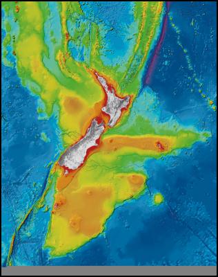
Caption
Undersea New
Zealand, a high resolution image of the complex and diverse
marine realm around New Zealand.
Undersea New Zealand provides a unique insight into the shape of the seafloor within one of the world’s most extensive deepwater jurisdictions. New Zealand straddles an active plate margin, creating a highly complex and diverse seascape of submarine trenches, underwater volcanoes, active submarine canyons and quiescent broad plateaux.
Photo credit
NIWA
Notes Copyright 2012 NIWA
Other information
about this item:
https://www.niwa.co.nz/our-science/oceans/common-questions/all/seafloor-mapping
https://www.niwa.co.nz/our-services/instruments/instruments/em300
 Raise Communications: NZ Careers Expo Kicks Off National Tour Amid Record Unemployment
 Hugh Grant: How To Build Confidence In The Data You Collect
 Tourism Industry Aotearoa: TRENZ 2026 Set To Rediscover Auckland As It Farewells Rotorua - The Birthplace Of Tourism
 NIWA: Students Representing New Zealand At The ‘Olympics Of Science Fairs’ Forging Pathway For International Recognition
 Coalition to End Big Dairy: Activists Protest NZ National Dairy Industry Awards Again
 Infoblox: Dancing With Scammers - The Telegram Tango Investigation