NIWA maps Mt Tongariro ash cloud shortly after the eruption
NIWA maps Mt Tongariro ash cloud shortly after
the eruption
Mt Tongariro erupted at 11.52pm on
6 August.
These latest infra-red satellite images of ash clouds over New Zealand were created using the NOAA 18 and 19 satellites.

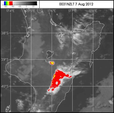
The first map, 0031 NZLT 7 August, was taken 39 minutes after the eruption.
NIWA Principal Scientist Michael Uddstrom, “What we are seeing [in this map] is infra-red imagery measured by the satellite during the event.” It shows the eruption cloud from the event. The cloud is 25 kilometres long and 15 kilometres wide.
The temperature at the top of the cloud (associated with the eruption) is minus 54 degrees centigrade and it's about 12 kilometres high at its highest point in the atmosphere.

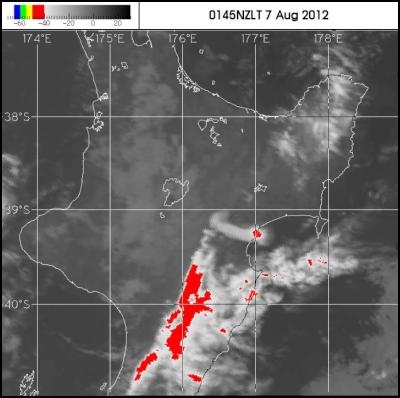
The second map, 0145 NZLT 7 August, was taken 113 minutes after the eruption.
The second map show the cloud as it extends from 176.4 degrees to 177.0 degrees east on the east coast of the North Island. At 1:45am the highest cloud was just over the coast, south of Wairoa, in the Central Hawkes Bay.

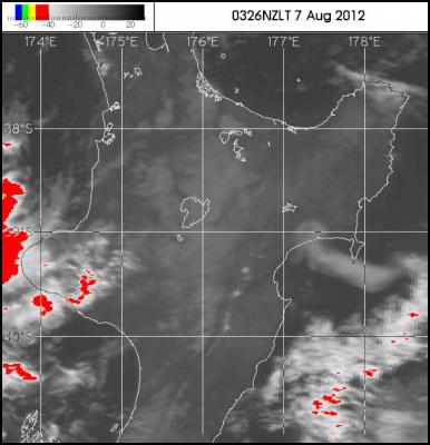
The third map, 0326 NZLT 7 August was taken 214 minutes after the eruption.
The third map shows the cloud south of Mahia, extending out from Hawke Bay.
The cloud has travelled 250 kilometres in four hours at an average speed of 18 metres per second.
“It's rapidly blowing out to the east of New Zealand,” says NIWA’s Dr Richard Turner.
If you want more information or analysis please get in touch with NIWA with your questions for comment.
If you use these images please credit NIWA and NOAA.
ENDS
To illustrate this story download
infra-red imagery from:
http://www.niwa.co.nz/gallery/mt-tongariro-eruption
| Photo file name | NOAA19_AM_VOLCANIC_DISP_20120806.GIF |
| Caption | Ash cloud over New Zealand 40 minutes after Mt. Tongariro erupts |
| Photo credit | NOAA 19 satellite and NIWA |
| Notes | The
colour-scale (predominantly grey-scale) is
temperature. Generally cold temperatures are bright and
warm temperatures are dark.
|
| Photo file name | noaa18_am_volcanic_disp_37167.jpg |
| Caption | Ash cloud over New Zealand at 1:45 am, on 7 August, nearly two hours after Mt Tongariro erupts. |
| Photo credit | NOAA 18 satellite and NIWA |
| Notes | The colour-scale
(predominantly grey-scale) is temperature. Generally cold
temperatures are bright and warm temperatures are dark.
|
| Photo file name | NOAA18_AM_VOLCANIC_DISP_37168.GIF |
| Caption | Ash cloud over New Zealand at 3:26 am on 7 August, nearly three and a half hours after Mt. Tongariro erupts. |
| Photo credit | NOAA 18 satellite and NIWA |
| Notes | The
colour-scale (predominantly grey-scale) is
temperature. Generally cold temperatures are bright and
warm temperatures are
dark. |


 Stats NZ: Total Greenhouse Gas Emissions Fall 0.7 Percent In The September 2024 Quarter
 Takapuna Beach Business Association: Takapuna Outpaces Auckland With Strong Economic Growth In 2024
 Commerce Commission: Bed, Bath And Beyond Sentenced Over Record Number Of Unsafe Products
 GE Free NZ: Minister Reti Asked For Two Week Delay Of Select Committee Deadline
 Science Media Centre: Government Plans To Double Mineral Exports By 2035 – Expert Reaction
 University of Canterbury: AI-powered Tool To Combat Rising Wildfire Danger


