 Scoop has an Ethical Paywall


July 2012: A month of two halves
National Climate Summary: July 2012 Issued: 6 August 2012
A month of two halves;
cold & dry to start, then wet & warm
| Rainfall | Extremely wet in Northland, Western Bay of Plenty, Waikato, Gisborne, southern Hawkes Bay, Wairarapa, Tasman, south Canterbury and parts of Otago. In contrast, it was unusually dry in Southland. |
| Temperature | The first half of July was unusually cold and dry, with particularly severe frosts between 1 and 5 July. In stark contrast, northwest winds produced unusual warmth mid-month, and the last half of July was extremely warm. Temperatures for the month as a whole were near average for many regions. The exceptions were the south and west South Island, and along the northeast coastal margin of both Islands (with above average temperatures). |
| Sunshine | An extremely sunny July for the western South Island and central-west North Island. Very cloudy in Gisborne, Wellington, and Nelson. |
| Soil moisture | As at the end of July, below normal soil moisture levels were observed in south Canterbury for the time of year. Near normal levels elsewhere. |
Overview
July started
unusually cold and dry, due to winter time anticyclones or
ridges prevailing over the country during the first half of
the month, bringing clear skies, light winds and a recipe
for frost. Frosts during the period 1 July to 5 July were
particularly severe. In stark contrast, northwest winds
produced unusual warmth in eastern areas mid-month. During
the last two weeks of July, lows dominated over the north
Tasman Sea, bringing unusually mild conditions, northeast
winds and high rainfall to northern and eastern regions of
the North Island, as well as Nelson/Marlborough.
For the
month as a whole, higher than normal pressures were observed
over New Zealand and to the southeast, with lower pressures
than usual over the north Tasman Sea. This resulted in more
northeast winds than usual over the North Island.
It
was an extremely wet July (with more than 150 percent of
July normal rainfall recorded) in parts of Northland, the
Western Bay of Plenty, Waikato, Gisborne, southern Hawkes
Bay, Wairarapa, Tasman, south Canterbury, and parts of
Otago. Other regions which experienced above normal rainfall
for July (between 120 and 149 percent of July normal)
included Taranaki and Westland. In contrast, it was an
unusually dry July for Southland, with rainfall totals less
than 50 percent of July normal. It was the driest July on
record for Invercargill and Tiwai Point. Rainfall was also
below normal for much of north Canterbury, Fiordland, and
between Wanganui and Waiouru (with totals between 50 and 80
percent of July normal). Elsewhere, near normal rainfall
(between 80 and 120 percent of July normal) were generally
observed. At the end of July, soils were much drier than
normal in south Canterbury, but soil moisture levels were
generally near normal elsewhere.
Because of the change mid-month from extremely cold and frosty conditions, to an unusually warm period, air temperatures for July as a whole were near average for many regions of the country (within 0.5°C of July normal). The exceptions were the south and west of the South Island, and along the northeast coastal margin of both Islands (where above average temperatures were observed, between 0.5°C and 1.2°C above the July average). Patches of below average temperatures (between 0.5°C and 1.2°C below the July average) were observed around Reefton. The nation-wide average temperature in July 2012 was 8.4°C (0.5°C above the 1971-2000 July average), using NIWA’s seven-station temperature series which begins in 1909.
It was an extremely sunny July for western and alpine regions of the South Island, with sunshine totals exceeding 125 percent of July normal. It was the sunniest July on record for Queenstown and Mt Cook. Above normal sunshine totals (between 110 and 124 percent of July normal) were observed in the central North Island, as well as Canterbury. In contrast, it was a rather cloudy July for Gisborne, Wellington, and Nelson (with between 75 and 90 percent of July normal sunshine experienced). Sunshine totals for July were near normal elsewhere (between 90 and 110 percent of July normal).
Further Highlights:
• The highest temperature was 22.6°C, observed at
Rangiora on 15 July.
• The lowest temperature was
-11.3°C, at Ranfurly on 2 July.
• The highest 1-day
rainfall experienced was 336 mm at North Egmont on 15
July.
• The highest gust recorded was 132 km/hr at Cape
Reinga on 29 July.
• Of the six main centres in July
2012, Tauranga was the warmest, wettest, and sunniest,
Christchurch the coolest, Dunedin the driest, and Wellington
the cloudiest.
--
Rainfall: Extremely wet in Northland, Western Bay of Plenty, Waikato, Gisborne, southern Hawkes Bay, Wairarapa, Tasman, south Canterbury and parts of Otago. In contrast, it was unusually dry in Southland.
It was an extremely wet July (with more than 150 percent of July normal rainfall recorded) in parts of Northland, the Western Bay of Plenty, Waikato, Gisborne, southern Hawkes Bay, Wairarapa, Tasman, south Canterbury, and parts of Otago. Other regions which experienced above normal rainfall for July (between 120 and 149 percent of July normal) included Taranaki and Westland. In contrast, it was an unusually dry July for Southland, with rainfall totals less than 50 percent of July normal. It was the driest July on record for Invercargill and Tiwai Point. Rainfall was also below normal for much of north Canterbury, Fiordland, and between Wanganui and Waiouru (with totals between 50 and 80 percent of July normal). Elsewhere, near normal rainfall (between 80 and 120 percent of July normal) were generally observed.
At the end of July, soils were much drier than normal in south Canterbury, but soil moisture levels were generally near normal elsewhere.
Record or near-record July rainfall totals were recorded at:
| Location | Rainfall total (mm) | Percentage of normal | Year records began | Comments |
| Record high or near-record high | ||||
| Kerikeri | 275 | 152 | 1981 | 4th-highest |
| Tauranga | 328 | 255 | 1898 | 4th-highest |
| Te Puke | 382 | 234 | 1973 | Highest |
| Hamilton | 224 | 173 | 1935 | 4th-highest |
| Takapau Plains | 229 | 197 | 1962 | 2nd-highest |
| Record low or near-record low | ||||
| Invercargill | 30 | 35 | 1939 | 4th-lowest |
| Tiwai Point | 20 | 23 | 1970 | Lowest |
| Nugget Point | 22 | 32 | 1930 | 3rd-lowest |
Temperature: Near average temperatures experienced in many areas. Above average temperatures for the south and west of the South Island, as well as along the northeast coast of both islands.
Because of the change mid-month from extremely cold and frosty conditions, to an unusually warm period, temperatures for July as a whole were near average for many regions of the country (within 0.5°C of July normal). The exceptions were the south and west of the South Island, and along the northeast coastal margin of both Islands (where above average temperatures were observed, between 0.5°C and 1.2°C above the July average). Patches of below average temperatures (between 0.5°C and 1.2°C below the July average) were observed around Reefton. The nation-wide average temperature in July 2012 was 8.4°C (0.5°C above the 1971-2000 July average), using NIWA’s seven-station temperature series which begins in 1909 [Interim monthly value].
Record or near-record monthly-average maximum air temperatures for July were recorded at:
| Location | Mean max. air temp. (oC) | Departure from normal (oC) | Year records began | Comments |
| High records or near-records | ||||
| Kaikohe | 15.6 | 1.6 | 1973 | 2nd-highest |
| Leigh | 17.0 | 1.9 | 1966 | Highest |
| Port Taharoa | 16.0 | 1.6 | 1973 | 2nd-highest |
| Ngawi | 13.3 | 0.7 | 1972 | 4th-highest |
| Ohakune | 11.3 | 2.0 | 1962 | 3rd-highest |
| Wanganui | 14.3 | 1.0 | 1937 | 4th-highest |
| Westport | 14.0 | 1.4 | 1937 | 2nd-highest |
| Lake Rotoiti | 9.9 | 1.3 | 1965 | 4th-highest |
| Hokitika | 13.3 | 1.4 | 1963 | 2nd-highest |
| Haast | 12.8 | 1.3 | 1949 | 3rd-highest |
| Milford Sound | 10.8 | 1.6 | 1934 | 3rd-highest |
| Secretary Island | 12.7 | 0.9 | 1985 | 3rd-highest |
| Motueka | 14.7 | 2.0 | 1956 | 2nd-highest |
| Nelson | 13.4 | 1.1 | 1943 | 4th-highest |
| Cheviot | 13.1 | 1.4 | 1982 | 3rd-highest |
| Mt Cook | 8.6 | 2.0 | 1929 | 2nd-highest |
| Ranfurly | 9.9 | 2.7 | 1975 | 2nd-highest |
| Dunedin | 11.4 | 1.4 | 1947 | 4th-highest |
| Invercargill | 11.0 | 1.7 | 1948 | 2nd-highest |
| Tiwai Point | 10.8 | 1.3 | 1970 | 3rd-highest |
Record
or near-record monthly-average minimum air temperatures for
July were recorded at:
| Location | Mean min. air temp. (oC) | Departure from normal (oC) | Year records began | Comments |
| Low records or near-records | ||||
| Ranfurly | -4.3 | -1.6 | 1975 | 3rd-lowest |
| High records or near-records | ||||
| Kaikohe | 9.4 | 1.4 | 1973 | 4th-highest |
| Farewell Spit | 8.2 | 2.0 | 1971 | 3rd-highest |
| Secretary Island | 7.8 | 1.5 | 1985 | 2nd-highest |
| Puysegur Point | 7.5 | 1.7 | 1978 | Highest |
| Cape Campbell | 7.7 | 0.7 | 1953 | 4th-highest |
| Kaikoura | 6.1 | 0.8 | 1963 | 4th-highest |
| Le Bons Bay | 6.0 | 1.1 | 1984 | 3rd-highest |
| Nugget Point | 4.3 | 0.9 | 1970 | 4th-highest |
Sunshine:
An extremely sunny July for the western and alpine South
Island. Rather sunny across central North Island, too.
Rather cloudy for Gisborne, Wellington, and
Nelson.
It was an extremely sunny
July for western and alpine regions of the South Island,
with sunshine totals exceeding 125 percent of July normal.
It was the sunniest July on record for Queenstown and Mt
Cook. Above normal sunshine totals (between 110 and 124
percent of July normal) were observed in the central North
Island, as well as Canterbury. In contrast, it was a rather
cloudy July for Gisborne, Wellington, and Nelson (with
between 75 and 90 percent of July normal sunshine
experienced). Sunshine totals for July were near normal
elsewhere (between 90 and 110 percent of July normal).
Record or near-record July sunshine hours were recorded at:
| Location | Sunshine hours | Percentage of normal | Year records began | Comments |
| High records or near-records | ||||
| Cheviot | 136 | 130 | 1983 | 3rd-highest |
| Mt Cook | 117 | 154 | 1930 | Highest |
| Queenstown | 159 | 180 | 1930 | Highest |
July climate in the six main centres
It was an extremely wet month for Tauranga, which recorded well over twice its usual July rainfall total. This ranked as the 4th-wettest July on record for Tauranga, with 328 mm of rainfall observed. There were several flooding events in the Western Bay of Plenty region during the month. It was also a wet month for Hamilton and Christchurch. In contrast, it was a relatively dry July for Dunedin.
Of the six main centres, Tauranga was the warmest, wettest, and sunniest; Christchurch was the coolest, Dunedin the driest, and Wellington the cloudiest.
July 2012 main centre climate statistics:
| Temperature | |||
| Location | Mean temp. (oC) | Departure from normal (oC) | Comments |
| Aucklanda | 10.4 | -0.5 | Below average |
| Taurangab | 10.8 | +0.5 | Above average |
| Hamiltonc | 8.7 | 0.0 | Near average |
| Wellingtond | 9.3 | +0.4 | Above average |
| Christchurche | 6.0 | +0.2 | Near average |
| Dunedinf | 7.5 | +1.0 | Above average |
| Rainfall | |||
| Location | Rainfall (mm) | % of normal | Comments |
| Aucklanda | 157 | 114% | Near normal |
| Taurangab | 328 | 255% | 4th wettest July on record |
| Hamiltonc | 224 | 173% | Well above normal |
| Wellingtond | 145 | 106% | Near normal |
| Christchurche | 92 | 142% | Above normal |
| Dunedinf | 47 | 83% | Near normal |
| Sunshine | |||
| Location | Sunshine (hours) | % of normal | Comments |
| Aucklanda | 134 | 102% | Near normal |
| Taurangab | 146* | 97% | Near normal |
| Hamiltong | 135 | 107g% | Above normal |
| Wellingtond | 101 | 85% | Below normal |
| Christchurche | 117 | 92% | Near normal |
| Dunedinf | 121 | 110% | Above normal |
a Mangere b Tauranga Airport c Hamilton Airport d Kelburn e Christchurch Airport f Musselburgh g Ruakura
*Site visit made 6/7/2012, possible under-reading 1-5 July.
Highlights and extreme events
Rain and
slips
The highest 1-day rainfall experienced in
July was 336 mm, recorded at North Egmont on 15 July.
A
severe thunderstorm crossed the Auckland region on 3 July,
bringing torrential rain for a short time and causing
surface flooding. The storm also caused power outages in
parts of Browns Bay, Beachlands, Clevedon, Maraetai, Rotoroa
Island, Whitford, Warkworth, and Waiheke Island. During the
storm, a fur seal was found in a building in South Auckland
200 m from the harbour, and another seal was found inland in
Devonport. Auckland Zoo was also flooded but no animals were
harmed. In the Bay of Plenty, flooding closed SH2 north of
Katikati. Both Waihi Beach and Katikati suffered flooding,
with homes evacuated, and cars under water.
On 4 July,
heavy overnight rain in the Gisborne area brought down the
roof of a petrol station’s car wash and caused surface
flooding on many roads in the district. Many sports grounds
were closed.
On 6 July, heavy rain washed away a
temporary road, closing SH56 at the Manawatu Gorge. Flooding
also closed SH56 at the Manawatu River Bridge.
On 15
July, flooding and slips closed SH6 between Inangahua and
Westport, and SH65 from Spring’s Junction to
O’Sullivan’s Bridge. The Takaka-Collingwood Highway in
Golden Bay was closed by flood debris on the road at the
Waitapu Bridge. Many Nelson city roads were also closed by
flooding.
On 16 July, SH73 was closed by a slip between
Springfield and Arthurs Pass. Westport suffered surface
flooding in the town, and was isolated by severe flooding
and slips on SH67 from Westport to Greymouth, SH6 from
Westport to Inangahua, SH67 from Westport to Karamea, and
SH69 to Reefton. Minor flooding occurred in Murchison, with
five homes inundated, and in Nelson where the Matai River
overflowed. In Marlborough, the Wakamarina River overflowed
its banks in several areas, and SH6 from Havelock to
Wangamoa was closed by severe flooding. A fallen tree
blocked the Picton end of Queen Charlotte Drive. In
Wellington, the harbour ferry was cancelled because of the
heavy rain and strong winds. In Upper Hutt, a woman was
rescued from her vehicle attempting to cross the Akatarawa
River, which had risen rapidly after the heavy rain, and a
rock fall affected SH2 north of the Haywards Hill traffic
lights. SH1 was closed by flooding between Taupo and
Turangi, as was SH43 between Taumarunui and Whangamomona.
SH3 was closed by a large slip north of the Awakino Hotel,
and many minor roads in Taranaki were closed by smaller
slips and surface flooding. At Coronet Peak, the ski area
was closed after rain soaked the snowpack.
On 17 July,
floodwaters isolated the King Country township of Ohura
after the swollen Ohura River burst its banks. Several roads
in the Ruapehu district were closed by flooding, slips or
downed trees. The road to Rainbow Ski Field was closed after
it was damaged by the heavy rain on 15 and 16 July. In New
Plymouth, the Huatoki walkway was closed after heavy rain
caused the path to slump. On 18 July, a large slip closed
Gladstone Road, east of Levin, isolating 20 to 30
properties.
On 23 July, SH2 was closed by a slip in the
Athenree Gorge and flooding in the Karanagahake Gorge, and
reduced to one lane by surface flooding in the Papamoa area.
SH26 between Paeroa and Te Aroha was closed by flooding.
Katikati was also affected by flooding and both Katikati
College and Katikati Primary School closed early. Waihi
Beach was isolated after both roads heading into the town
were closed. In the Coromandel, the Tapu-Coroglen Road was
blocked by land slips. In Auckland, heavy rain brought down
a tree in Titirangi, closing the road.
On 24 July, slips
closed SH2 near Apata, and SH25 between Thames and
Coromandel, and between Coromandel and Whitianga. In
Gisborne, pupils were sent home from Kaiti School after
flash floods entered classrooms and a toilet block. In the
Waikato, flash floods inundated Cambridge homes, and a large
slip left a 2 m high mound on Te Puroa Road, cutting off 24
properties, and isolating about 80 residents. In Hawkes Bay,
the Clive River overflowed, damaging property, reserves and
walkways.
On 25 July, one lane of SH35 was closed by a
slip south of Hicks Bay. On 26 July, a slip closed SH25 on
the Thames Coast at Ruamahunga Bay. In Wellington, a slip
closed Raroa Crescent, one of the main routes into the city
from the western suburbs. A slip also had to be cleared from
SH2 at Horokiwi.
On 30 July, heavy rain caused a slip on
SH29 near the summit on the Matamata side of the Kaimai
Ranges, surface flooding on SH1 near the SH29 turnoff, SH26
between Paeroa and Te Aroha, and between Paeroa and
Hikutaia, SH25 at the Thames Coast Road and further north at
Manaia, and minor slips at Ruamahanga, Tapu and Kereta. In
the Tauranga area, the heavy rain flooded roads, and the
accompanying strong winds, brought down trees and power
lines. In Dunedin, heavy rain caused surface flooding and
property damage in the suburb of Helensburgh.
On 31
July, heavy rain caused surface flooding on SH8 between
Fairlie and Lake Tekapo, SH79 between Fairlie and Geraldine,
and SH83 between Duntroon and Kurow. Surface flooding closed
many other roads in South Canterbury, including Dansey’s
Pass, with SH1 between Pukeuri and the Waitaki Bridge
requiring extreme care. In Christchurch, the Heathcote River
burst its banks after two days of heavy rain, flooding the
surrounding area. In Tauranga, heavy overnight rain caused
the sewer system to overflow into the Waikareao Estuary. The
Daisy Hardwick Walkway around the Waikareao Estuary was
closed after a section of the seawall collapsed.
Record or near record July extreme 1-day
rainfall totals were recorded at:
| Location | Extreme
1-day rainfall (mm) | Date of extreme rainfall | Year records began | Comments |
| Te Puke | 86 | 15th | 1973 | 4th-highest |
| Taumarunui | 60 | 15th | 1913 | 3rd-highest |
| Turangi | 62 | 15th | 1968 | 4th-highest |
| Hicks Bay | 96 | 3rd | 1916 | Highest |
| Levin | 48 | 15th | 1949 | 3rd-highest |
| Takaka | 204 | 14th | 1976 | Highest |
| Hokitika | 96 | 13th | 1963 | 2nd-highest |
| Reefton | 74 | 14th | 1960 | 3rd-highest |
| Greymouth | 89 | 14th | 1947 | 3rd-highest |
| Haast | 114 | 13th | 1943 | 3rd-highest |
| Cromwell | 35 | 30th | 1949 | 3rd-highest |
Temperatures
The highest temperature in July was 22.6°C, observed at Rangiora on 15 July. The lowest temperature was -11.3°C, recorded at Ranfurly on 2 July.
On 4 July, after several days of extremely cold weather, 10 parking meters in Gore lost their heads after water in the pipes froze, pushing the 20 kg cast iron tops off their stands.
A large number of records and near-records for highest minimum (morning) and maximum (afternoon) temperatures were observed in the second half of July, associated with the dominant northerly wind flows during that part of the month. July 15 was particularly warm in eastern areas.
Record or near-record daily maximum air temperatures for July were recorded at:
| Location | Extreme maximum (°C) | Date of extreme temperature | Year records began | July ranking
|
| High records or near-records | ||||
| Kaitaia Observatory | 19.6 | 25th | 1985 | Equal 2nd-highest |
| Kaikohe | 19.1 | 23rd | 1973 | Highest |
| Leigh | 19.5 | 20th | 1966 | Highest |
| Port Taharoa | 19.9 | 26th | 1973 | Highest |
| Turangi | 16.9 | 24th | 1968 | 4th-highest |
| Martinborough | 18.3 | 16th | 1986 | 3rd-highest |
| Ngawi | 18.5 | 20th | 1972 | Equal 2nd-highest |
| Paraparaumu | 17.8 | 24th | 1953 | 4th-highest |
| Ohakune | 17.2 | 30th | 1962 | 2nd-highest |
| Lake Rotoiti | 13.5 | 18th | 1965 | 2nd-highest |
| Secretary Island | 17.7 | 25th | 1985 | 2nd-highest |
| Motueka | 19.9 | 18th | 1956 | Highest |
| Culverden | 19.6 | 15th | 1928 | 4th-highest |
| Cheviot | 22.3 | 15th | 1982 | Highest |
| Mt Cook | 18.3 | 19th | 1929 | 2nd-highest |
| Waipara West | 21.3 | 20th | 1973 | 3rd-highest |
| Christchurch | 22.4 | 15th | 1863 | 2nd-highest |
| Tara Hills | 15.1 | 18th | 1949 | Equal 4th-highest |
| Dunedin | 18.4 | 18th | 1947 | 4th-highest |
| Lauder | 17.1 | 18th | 1924 | Equal 3rd-highest |
| Nugget Point | 16.1 | 18th | 1970 | 3rd-highest |
| Low records or near-records | ||||
| Whatawhata | 7.6 | 5th | 1952 | Equal 4th-lowest |
| Hamilton | 6.4 | 5th | 1940 | 3rd-lowest |
| Alexandra | -1.9 | 5th | 1983 | 4th-lowest |
Record or near-record daily minimum
air temperatures for July were recorded at:
| Location | Extreme
minimum (°C) | Date of extreme temperature | Year records began | July ranking
|
| Low records or near-records | ||||
| Te Kuiti | -3.9 | 2nd | 1959 | 3rd-lowest |
| Turangi | -6.7 | 2nd | 1968 | 4th-lowest |
| Paraparaumu | -4.0 | 2nd | 1953 | Equal 3rd-lowest |
| Hawera | -2.9 | 2nd | 1977 | 4th-lowest |
| Wanganui | -1.5 | 27th | 1987 | 4th-lowest |
| Orari Estate | -6.5 | 2nd | 1972 | Equal 2nd-lowest |
| Timaru | -6.8 | 24th | 1990 | 3rd-lowest |
| Ranfurly | -11.3 | 2nd | 1975 | 2nd-lowest |
| Queenstown | -7.7 | 5th | 1871 | 4th-lowest |
| Lumsden | -8.0 | 4th | 1982 | 2nd-lowest |
| Alexandra | -8.9 | 2nd | 1983 | 2nd-lowest |
| Balclutha | -6.0 | 2nd | 1964 | Equal 2nd-lowest |
| High records or near-records | ||||
| Cape Reinga | 14.4 | 23rd | 1971 | 4th-highest |
| Kerikeri | 14.6 | 16th | 1981 | Equal 4th-highest |
| Kaikohe | 14.3 | 16th | 1973 | 2nd-highest |
| Dargaville | 14.2 | 16th | 1951 | 3rd-highest |
| Whangaparaoa | 13.2 | 16th | 1982 | Equal 4th-highest |
| Whitianga | 14.3 | 16th | 1971 | Equal 4th-highest |
| Paeroa | 13.9 | 16th | 1971 | 4th-highest |
| Taupo | 10.9 | 16th | 1950 | Equal 2nd-highest |
| Auckland | 14.1 | 16th | 1961 | 4th-highest |
| Port Taharoa | 13.8 | 16th | 1974 | 4th-highest |
| Taumarunui | 12.3 | 16th | 1947 | 4th-highest |
| Hastings | 12.7 | 16th | 1972 | 4th-highest |
| Waipawa | 11.2 | 16th | 1945 | 2nd-highest |
| Wairoa | 13.9 | 16th | 1972 | 3rd-highest |
| Stratford | 11.3 | 16th | 1972 | 3rd-highest |
| Hawera | 12.1 | 16th | 1977 | Equal 2nd-highest |
| Ohakune | 10.9 | 16th | 1972 | Highest |
| Wanganui | 12.3 | 15th | 1972 | Equal 4th-highest |
| Takaka | 13.1 | 15th | 1978 | Highest |
| Farewell Spit | 13.3 | 15th | 1972 | 3rd-highest |
| Westport | 13.0 | 15th | 1966 | Highest |
| Lake Rotoiti | 7.1 | 15th | 1972 | 4th-highest |
| Hokitika | 11.6 | 15th | 1964 | Highest |
| Reefton | 9.2 | 15th | 1972 | 3rd-highest |
| Greymouth | 11.5 | 15th | 1972 | 2nd-highest |
| Haast | 10.8 | 15th | 1949 | Equal 4th-highest |
| Secretary Island | 11.2 | 19th | 1988 | 2nd-highest |
| Puysegur Point | 12.7 | 29th | 1978 | Highest |
| Motueka | 10.8 | 16th | 1972 | Equal 3rd-highest |
| Nelson | 12.6 | 15th | 1943 | 2nd-highest |
| Appleby | 12.1 | 15th | 1943 | 3rd-highest |
| Arthurs Pass | 7.4 | 16th | 1973 | Equal 3rd-highest |
| Cheviot | 8.2 | 31st | 1982 | Equal 4th-highest |
| Orari Estate | 6.9 | 15th | 1972 | 3rd-highest |
| Lumsden | 7.1 | 18th | 1982 | 4th-highest |
Wind
On
3 July, strong winds lifted a roof in Hobson Street,
Auckland, causing police to close the road until the roof
had been secured.
On 29 July, a horse float was blown
over on SH1 at Uretiti, south of
Whangarei.
Lightning and hail
On
3 July, Waihi Beach was blanketed in
hailstones.
Snow and ice
On 3
July, ice warnings were in place for SH6 and SH8 in Otago,
SH94 to Milford Sound, and SH1 from Balclutha to
Dunedin.
On 4 July, snow on SH73 at Porters Pass closed the road to towing vehicles. On 5 July a bonspiel call was put out for curlers to compete on the Idaburn Dam.
On 9 July, Frankton Marina on Lake Wakatipu was frozen, with the ice firm enough to allow curling. Jet boats could not be taken out because of ice in the Shotover River.
On 10 July, warnings were issued for SH8 which was affected by both ice and fog between Twizel and Lake Tekapo.
Cloud and fog
On 5 July, thick fog forced the cancellation of outgoing and incoming flights at Auckland Airport. Many other flights were delayed. Warnings were issued for SH1 in the Auckland region. On 6 July, fog again caused the cancellation or delay of flights at Auckland Airport. Fog also caused the cancellation of flights at Hamilton Airport and Christchurch Airport.
On 16 July, fog blanketed Nelson in the late afternoon, delaying flights into and out of Nelson Airport.
On 19 July, heavy fog blanketed parts of Auckland, causing the delay or cancellation of several domestic flights into and out of the airport.
On 24 July, heavy fog again caused the cancellation or delay of many domestic flights into and out of Auckland Airport. Flights were also cancelled at Whangarei, Kaikohe and Kerikeri airports.
On 25 July, fog again caused cancellations at Northland airports.
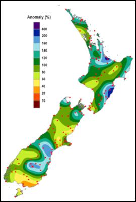
July 2012 rainfall, expressed as an anomaly from normal July conditions (% of July normal rainfall). Areas which received less than half of usual July rainfall are shown in yellow or orange colours (Southland and parts of Canterbury). Areas which were unusually wet (experiencing more than one and a half times the usual July rainfall) are shown in blue shades; namely Bay of Islands, Western Bay of Plenty, the Waikato, Gisborne, southern Hawkes Bay and the Tararua District, Tasman, Marlborough, south Canterbury, and northern and central Otago. Dots are climate station locations.
www.niwa.co.nz/ncc © Copyright NIWA
2012 All rights
reserved.
 Commerce Commission: Commission Calls For Comments On Copper Access Deregulation
 New Zealand Association of Scientists: NZAS Supports Saving Biotechnology Capacity In Callaghan; Asks What Now For Applied Technology Group
 Stats NZ: Business Employment Data - December 2024 Quarter
 Transpower: System Operator Launches Review Of Electricity Risk Forecasting Framework
  The Conversation: NZ’s Glaciers Have Already Lost Nearly A Third Of Their Ice – As More Vanishes, Landscapes And Lives Change
 RBNZ: Reserve Bank Of New Zealand Welcomes The Release Of Te Ōhanga Māori 2023 Report


