Monday’s Quakes Not on Port Hills Fault, Scientists Say

Click for big version
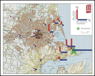
This graphic shows the measured vertical and horizontal ground accelerations resulting from Monday's magnitude 6.3 earthquake in Christchurch.
MEDIA RELEASE from GNS Science
14 JUNE 2011
Monday’s Quakes Not on Port Hills Fault, Scientists Say
Scientists analysing Monday’s quakes in Christchurch say they occurred on a fault structure 2km to 3km south of the Port Hills fault that ruptured on February 22, 2011.
There have been six aftershocks of magnitude 4, or greater, on this fault, or very close to this fault, since February.
The Richter magnitudes for Monday’s two main quakes were revised up to magnitude 5.6 and magnitude 6.3 as more data was incorporated into the analysis.
“The initial estimates of size and location were based on data received within minutes of Monday’s earthquakes occurring. The revised magnitudes incorporate data from about 250 seismographs throughout New Zealand,” said seismologist Bill Fry of GNS Science.
It is likely that stresses from the Monday’s magnitude 5.6 triggered the more substantial magnitude 6.3 earthquake, Dr Fry said.
“Technically this makes the magnitude 5.5 a foreshock, or precursor, of the magnitude 6.3.”
The energy released in both quakes was high, as has been common for most earthquakes associated with the 10-month-long Canterbury sequence.
“This contributed to the anomalously high shaking intensity of the earthquakes, as the amount of shaking is proportional to the energy released.
“The spatial size of the underground rupture area for the magnitude 6.3 quake was relatively small for the amount of energy released. This implies that the fault was very strong,” Dr Fry said.
As the fault rupture mechanism for Monday’s magnitude 6.3 was similar, but not identical, to the magnitude 6.3 of February 22, the pattern of resultant stress change in the earth’s crust in the region is also similar.
“Ultimately, most of the earthquakes that have occurred during the aftershock sequence, including those on June 13, are consistent with what is expected due to the regional stress regime in Canterbury."
The force of shaking at ground level, or the peak ground acceleration (PGA), recorded in Christchurch during Monday’s magnitude 6.3 earthquake ranged from 212% of gravity in Sumner to about 30% of gravity in the CBD.
“In comparison, much of the Christchurch CBD experienced greater than 50%g shaking during the February magnitude 6.3 earthquake,” Dr Fry said.
Other Peak Ground Acceleration measurements were 77%g in Mount Pleasant, 64%g in Lyttelton, 43%g in Hulverstone, 25%g in Governors Bay, and 17-34%g in the CBD.
Dr Fry said the high acceleration measurement in Sumner may have been influenced by ‘topographic effects’. This can occur when the shape of landforms can focus seismic waves, like light through a lens, and make them bigger.
The dominant energy in Monday’s aftershocks was horizontal. By comparison, the dominant energy in February’s magnitude 6.3 quake was vertical. This helped to explain why people in Christchurch felt the February and June quakes differently.
The widespread liquefaction that occurred on Monday was consistent with the level of shaking that occurred. Peak Ground Acceleration values as low as 20%g triggered liquefaction in February.
ENDS


 Hugh Grant: How To Build Confidence In The Data You Collect
 Tourism Industry Aotearoa: TRENZ 2026 Set To Rediscover Auckland As It Farewells Rotorua - The Birthplace Of Tourism
 NIWA: Students Representing New Zealand At The ‘Olympics Of Science Fairs’ Forging Pathway For International Recognition
 Coalition to End Big Dairy: Activists Protest NZ National Dairy Industry Awards Again
 Infoblox: Dancing With Scammers - The Telegram Tango Investigation
 Consumer NZ: This Mother’s Day, Give The Gift Of Scam Protection And Digital Confidence