Rare ‘Double-Whammy’ Quakes Near Tonga
MEDIA RELEASE 19 August
2010
Scientists Uncover Rare
‘Double-Whammy’ Quakes Near Tonga
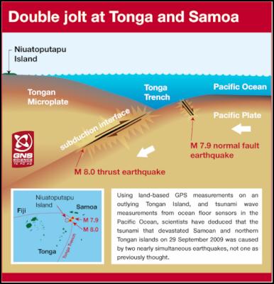
Scientists have found that the tsunami that devastated parts of Tonga and Samoa in September 2009 was caused by two almost simultaneous earthquakes, not one as previously thought.
A double strike of two large earthquakes within minutes of each other, and with one quake ‘hiding’ the other, is unusual and almost certainly increased the size of the tsunami and its destructiveness on some Tongan islands.

Global earthquake readings and GPS recordings from Samoa initially indicated a single large ‘normal-faulting’ quake of magnitude 8 had occurred.
However, tsunami modellers at GNS Science noticed that tsunami waves recorded by deep ocean tsunami gauges in the southwest Pacific strongly indicated the earthquake was a ‘thrust’ event, which has a compressional movement within the earth’s crust rather than the extensional motion from a normal-faulting earthquake.
No matter how hard the tsunami modellers tried, they were unable to reconcile the tsunami gauge data with the data from permanent GPS instruments in Samoa and global seismic recordings.
However, six weeks after the event GPS measurements from a small Tongan island showed there must have been two large earthquakes - and the tsunami gauge readings indicated these earthquakes must have occurred within a couple of minutes of each other.
 The finding
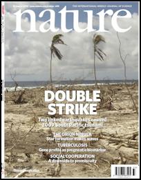
appears this week as the cover story in the prestigious
science publication Nature in a paper called
‘Near-simultaneous great earthquakes at Tongan megathrust
and outer rise in September 2009’.
Lead author John Beavan, a geophysicist at GNS Science, said the conflicting data was initially very perplexing, and the discrepancies could not be resolved in spite of determined efforts by a group of his colleagues.
“In the end, it was pure detective work that uncovered the two earthquakes,” Dr Beavan said.
Several weeks after the earthquake, colleagues in Tonga obtained post-earthquake GPS measurements from two survey marks on the outlying Tongan island of Niuatoputapu.
“The files arrived from Tonga in early November 2009. When I processed the data and looked at the GPS results I was astonished to see that the island of Niuatoputapu had moved nearly 400mm to the east.”
This was a much bigger displacement than was expected, and in a completely different direction.
The GPS results from Niuatoputapu could be reconciled with the Samoan GPS data, the deep-ocean tsunami observations and global seismic observations if two separate earthquakes had occurred – one a thrust-faulting earthquake on the dipping interface between the Pacific plate and the Tonga microplate above, and the other a normal-faulting earthquake within the Pacific plate as it bends before entering the Tonga subduction zone at the Tonga trench.
“We worked hard for a couple of months to ensure there was no other explanation for the GPS and tsunami observations, which were telling us that two nearly simultaneous earthquakes had occurred.”
The earthquakes occurred under the ocean floor about 70km apart and within a couple of minutes of each other. Researchers at GNS Science could not be certain which quake had occurred first. The subduction thrust earthquake was magnitude 8.0 and the other earthquake was magnitude 7.9.
“The tsunami impacts at Niuatoputapu and Tafahi islands in northern Tonga may have been significantly exacerbated by the double earthquake, though we need to do more detailed tsunami modelling to fully understand this.”
It is rare for two large earthquakes to occur so close together in time. Dr Beavan said it was possible scientists had not recognised large double-whammy earthquakes in the past because seismic waves become entangled making it almost impossible to distinguish individual earthquakes when they occur close together.
Dr Beavan said it was possible, though unlikely, that two large near simultaneous earthquakes could occur on the plate boundary under New Zealand.
“This is a rare phenomenon, but it is possible wherever there is a subduction-type plate boundary.”
Dr Beavan co-wrote the Nature paper with five colleagues from GNS Science, and one each from Ohio State University and the Ministry of Lands, Survey, Natural Resources and Environment, Tonga.
A second paper by a group of US and French seismologists appears in the same issue of Nature, and uses seismological methods – quite different from the methods used in the GNS Science study – to come to similar conclusions about the 29 September earthquakes.
ENDS


 Financial Markets Authority: Westpac Admits To Misleading Representations That Resulted In $6.35m In Overcharges
 Bill Bennett: Download Weekly - Review Of 2024
 Bill Bennett: One NZ scores worldwide first as Starlink direct-to-mobile launches
 Hugh Grant: How To Reduce Network Bottlenecks
 Dominion Road Business Association: Auckland Transport's 'Bus To The Mall' Campaign: A Misuse Of Public Funds And A Blow To Local Businesses
 Parrot Analytics: A Very Parrot Analytics Christmas, 2024 Edition


