Evidence Of Recent Undersea Eruption Off NZ Coast
MEDIA RELEASE from GNS Science,
12 MARCH 2009
Scientists Find Evidence Of Recent Undersea Eruption

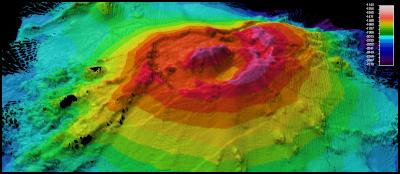
Click for big version
Bathymetic map of Rumble II West volcano

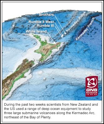
Click for big version
Location of Rumble II West volcano
Scientists have
returned from exploring three submarine volcanoes in the
Kermadec Arc where they found evidence of a recent large
eruption at one of the volcanoes.
While mapping the Rumble III volcano, they found a marked change in the shape of the summit. A map made in 2007 showed an 800m-wide crater near the top of the submarine volcano.
The new map shows the crater has been filled and the nearby summit cone has been reduced in height by about 100m.
"This suggests there has been a major eruption that collapsed the summit cone and filled the adjacent crater," said Co-Chief Scientist on the voyage Cornel de Ronde of GNS Science.
Images taken by an underwater camera towed by the research ship show strewn lava boulders covered by black volcanic ash near the summit of the volcano, Dr de Ronde said. Rumble III volcano is about 350km northeast of the Bay of Plenty and sits at a depth of 1.4km.
The eruption is consistent with the fact that a number of the 90 submarine volcanoes along the Kermadec Arc are highly active. Some of the volcanoes along this 2000km underwater volcanic chain are as big as Mt Ruapehu.
The Kermadec Arc runs northeast of New Zealand between the Bay of Plenty and Tonga.
The two-week voyage, a joint United States and New Zealand project, ends today with the ship berthing in Auckland. The ship, R/V Thomas G Thompson, is one of America's top ocean-going research ships and is owned and operated by the University of Washington.
The purpose of the voyage was to enable 13 final-year oceanographic students from the University of Washington and four students from Southampton University in England to complete their theses. It also offered the opportunity for scientists from the US and New Zealand to gather fresh information on submarine volcanoes.
At Brothers volcano, underwater equipment towed by the ship showed vigorous hydrothermal venting expelling high-temperature, mineral-rich plumes into the ocean.
At another site at Brothers, lower temperature acidic fluids were venting into the ocean. Areas around this vent were covered in dense accumulations of long-neck barnacles.
Expedition leader, Professor Rick Keil of the University of Washington, described the voyage as the opportunity of a lifetime for him and his students to carry out research with colleagues from GNS Science.
"Unlike classroom teaching, this voyage was the real deal."
A marine biologist with Woods Hole Oceanographic Institution, Timothy Shank, said he had been to more than 30 hydrothermal vent sites around the world and had not seen long-neck barnacles as dense or numerous as those at Brothers volcano.
"The question is, how do these animals manage to thrive in this incredibly extreme environment? New Zealand scientists are lucky having this wonderful natural environment right in their backyard."
A marine geologist with Woods Hole Oceanographic Institution in the US, Dan Fornari, said the voyage gave the students experience in using a state-of-the-art fibre optic deep-sea imaging system.
"It is a Jules Vernian experience to traverse the ocean floor and see first-hand things that people have never seen before. There's nothing like that to motivate a student," Dr Fornari said.
Dr de Ronde said a highlight of the voyage was finding evidence of a catastrophic collapse at the summit of Rumble III volcano.
The voyage underlined the fact that Kermadec Arc contained some of the most spectacular undersea volcanoes in the world.
"As well as that, some of these volcanoes are highly accessible as their summits come within a few hundred metres of the sea surface. At most other places in the world, submarine volcanoes are in deeper water."
Go here for a voyage blog by GNS Science researcher Heidi Berkenbosch: http://data.gns.cri.nz/hazardwatch/gsblogs/heidi.html
Link to the Woods Hole Oceanographic Institution underwater tow-cam website: http://www.whoi.edu/page.do?pid=17619
Above Images: A location graphic and a new bathymetic map of Rumble II West volcano made during the voyage. Rumble II West is a large conical volcano sitting at 1.4km depth.
ENDS


 REINZ: Cautious Confidence Returns To The Property Market
 FSCL: Financial Ombudsman Service, FSCL, Rated Accessible And Fair Dispute Resolution Service In Independent Review
 The Reserve Bank of New Zealand: Monetary Policy Affects Some Parts Of The Economy Differently - RBNZ Analytical Note
 Tātaki Auckland Unlimited: Iconic Auckland Eats 2025 Top 100 Dishes Revealed After Record Number Of Nominations
 Hugh Grant: What Is Cloud Migration And How Does It Work
 Property Council New Zealand: Hiwa Recreation Centre Takes Top Award At 2025 Property Industry Awards


