 Scoop has an Ethical Paywall


Eagle eye on erosion will help reduce flood risk
Eagle eye on erosion will help reduce flood risk
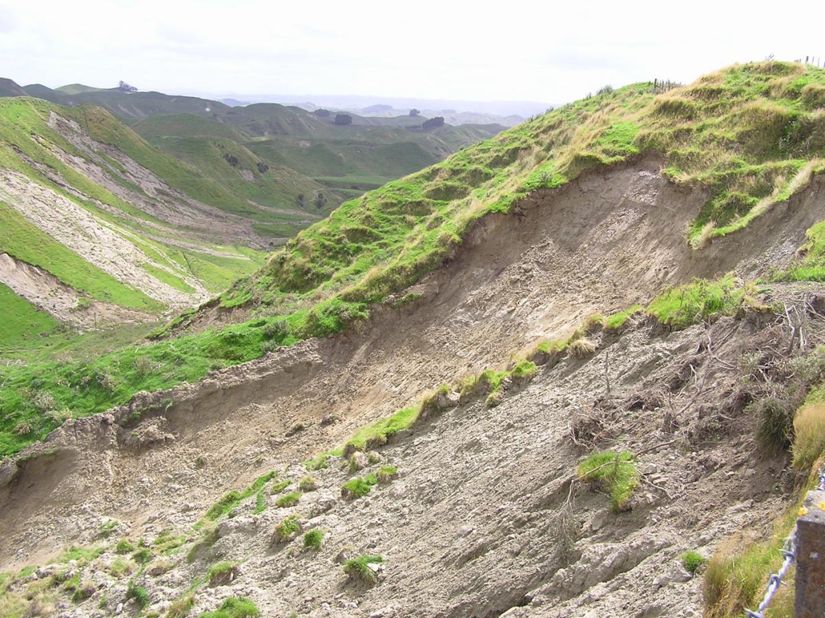
Click to enlarge
A typical erosion scar, approximately 1 metre deep, from the 2004 Manawatu floods. Land that has suffered this type of erosion takes about 80 years to recover productivity.
There were 62,000 landslides during this storm event. Work by SLURI will help regional councils identify vulnerable land and minimise erosion and flood damage.
Eagle eye on erosion will help reduce flood risk
Scientists from the Sustainable Land Use Research Initiative (SLURI) have developed a system for gauging the effects of erosion in New Zealand. Their work will help regional councils identify and target the most vulnerable land, to minimise erosion and flood damage.
About 210 million tonnes of sediment is washed into New Zealand’s rivers each year – ten times the global average. While much of this erosion is caused by natural processes, it can be greatly accelerated by humans, for example through the conversion of hill country from forest to pasture. During storms large volumes of sediment can severely decrease the volume of flood channels, exacerbating flood damage and destroying fish habitats. Climate change is expected to increase storminess.
Landcare Research scientist Dr John Dymond leads the SLURI team that created the New Zealand Empirical Erosion Model (NZEEM). The computer model was created as a response to the devastating 2004 Manawatu floods.
NZEEM predicts mean annual soil loss from annual rainfall, type of terrain, and percentage of woody cover, and can be used for large or small catchments throughout New Zealand.
“In the past, we knew what was going on in a paddock or a farm, and that we might have to plant more trees to curb erosion in those paddocks,” Dr Dymond says. “With NZEEM we can map the current erosion rates for all of New Zealand.
“We can calculate the likely extent of erosion under different types of land cover. We can even calculate what erosion rates were like before humans came to New Zealand.”
The information is specific to 1:50 000 scale, and has the potential to be used by policy makers and land managers to significantly reduce spending on reducing flood risks. “We can use NZEEM to pinpoint the farms where much of the erosion is occurring,” Dr Dymond says. “During the Manawatu flood 100 million tonnes of soil eroded, polluting streams and causing more than $100 million worth of damage to infrastructure. Our work for Horizons Regional Council has shown that of 5000 farms in the Manawatu–Wanganui region, 500 of them were producing 50% of the eroded soil.
“Now we can prioritise soil conservation work in those areas, and identify the farms that most need it. With this knowledge, a little money can go a long way.”
Background information on SLURI
SLURI
is a national research effort involving four Crown Research
Institutes: Landcare Research, AgResearch, Crop & Food
Research and HortResearch. Working collaboratively with a
range of stakeholders and other research providers, SLURI
aims to increase understanding of New Zealand’s soils to
help us to maintain and manage them more
effectively.
ENDS
 Hugh Grant: How Can Telehealth And Home Healthcare Solutions Be Helpful?
 New Zealand Merino Company: The New Zealand Merino Company Will Investigate PETA Claims
 New Zealand Certified Builders: Building A Granny Flat? Four Things You Should Know
 Paul Scofield & George Young, The Conversation: The Discovery Of A Rare New Fossil Sheds Light On NZ’s Extinct Dolphin-like Reptiles
 Spirits New Zealand: A Year Of Two Halves For The NZ Spirits Industry
 MoneyHub: Comprehensive Guide To New Zealand Wage And Salary Distributions


