Steady Erosion of Ruapehu Crater Dam
Laser Measurements Show Steady Erosion of Ruapehu Crater Dam
Government-owned science company GNS Science is using new laser technology to accurately measure erosion rates of the tephra dam at Mt Ruapehu’s Crater Lake.
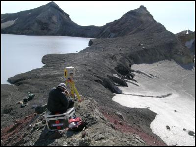
Using a technique called terrestrial laser scanning, scientists have created a detailed three-dimensional image of the entire dam to improve the understanding of the way natural dams fail.
The project is part of ongoing research on the dam by GNS Science, Massey University, Victoria University of Wellington, and the Department of Conservation. This project has been initiated and paid for by GNS Science.
Data gathering at the Crater Lake involves using a tripod-mounted instrument to take laser measurements across the dam. Each survey collects about 1 million surveyed points at high resolution across the entire dam.
The scientists are planning multiple surveys which will enable them to identify erosion rates between subsequent scans as well as pinpointing parts of the dam that are undergoing deformation.
Each survey, which involves a helicopter trip to the Crater Lake, takes about four hours.
Project leader Chris Massey, of GNS Science, said the first two surveys – taken on January 18 and February 8 - had shown marked erosion on the outside surface of the dam as seepage increases from the Crater Lake. Another four surveys are planned during the coming weeks.
“ The surveys have enabled us to create a model of the entire dam at a resolution of 10 centimetres, both vertical and horizontal. This will give us a valuable insight into the rate at which the dam is eroding,” Mr Massey said.
The terrestrial laser scanning technology, which is relatively new to New Zealand, will help scientists understand the mechanisms involved in the failure of natural dams. It also has implications for a better understanding of landslides.
GNS Science is trialling the equipment under a lease agreement to assess its value as an additional capability for earth science in New Zealand. The equipment is being leased from Wellington-based company GeoSystems.
ENDS


 Canterbury Museum: Mystery Molars Lead To Discovery Of Giant Crayfish In Ancient Aotearoa New Zealand
 Ngā Pae o te Māramatanga: Māori Concerns About Misuse Of Facial Recognition Technology Highlighted In Science
 Retail NZ: Retailers Call For Flexibility On Easter Trading Hours
 WorkSafe NZ: Worker’s Six-Metre Fall Prompts Industry Call-Out
 PSGR: Has MBIE Short-Circuited Good Process In Recent Government Reforms?
 The Reserve Bank of New Zealand: RBNZ’s Five Year Funding Agreement Published


