Lahar measuring equipment installed on Ruapehu
Researchers install lahar measuring equipment at Ruapehu Crater Lake

Click to enlarge
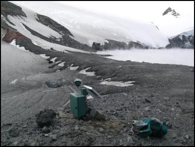
Automatic camera overlooking the tephra dam on the rim of Ruapehu’s Crater Lake. (V. Manville, GNS Science)

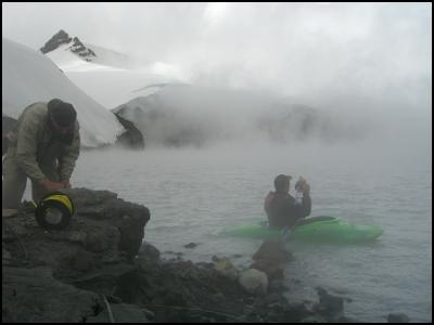
Dr Vern Manville (GNS Science) and Jay Bennett (Kiwi River Safaris) preparing to install a lake level sensor on Ruapehu’s Crater Lake. (photo H. Keys, DoC)
Researchers install lahar measuring equipment at Ruapehu Crater Lake
Scientists from GNS Science and the Department of Conservation installed a set of lake-monitoring equipment on Mount Ruapehu last weekend.
The instruments include a sensor to measure the rate of fall in lake level during any break-out event and a fixed digital camera overlooking the tephra dam to record its erosion.
The equipment, purchased by the GeoNet project which is run by GNS Science, had been monitoring the crater lake on White Island. It was relocated due to the rising water levels at Mt Ruapehu. A professional kayaker from Kiwi River Safaris paddled out onto the lake to install the level sensor.
“By knowing the shape of the lake basin and measuring the rate and amount of drawdown, we can reconstruct how quickly the water escapes during initiation of a lahar,” said project leader for GNS Science Dr Vern Manville.
“We can compare this with measurements taken further downstream to see how the lahar evolves.”
The equipment is the second in a series of planned deployments that are being made over the summer months, to obtain as much information as possible from any lahar along the expected flow path.
Late last year researchers installed electronic equipment in the Whangaehu Valley to measure the speed and depth of a lahar.
A lahar could be caused by a collapse of the tephra barrier at the Crater Lake, or it could be triggered by a volcanic eruption. Lahars are common on Ruapehu and the data obtained from this research could have immense value worldwide.
The research is funded by a Royal Society Marsden grant, the Earthquake Commission, and the Foundation for Research Science and Technology, and is being undertaken jointly with Massey University.
ENDS


 Engineering New Zealand: NZ Building System Needs Urgent Improvement
 GNS Science: Bioshields Could Help Slow Tsunami Flow
 Transport and Infrastructure Committee: Inquiry Into Ports And The Maritime Sector Opened
 Netsafe: Netsafe And Chorus Power Up Online Safety For Older Adults
 RBNZ: 10 Cent Coin With King Charles III Image Now In Production
 NZALPA: Safety Improves From AKL Incident Learnings


