 Scoop has an Ethical Paywall


Revolutionising Marine Forecasting
Revolutionising Marine Forecasting For Efficiency & Safety In Marine Operations
Revolutionising Marine Forecasting For Efficiency & Safety In Marine Operations
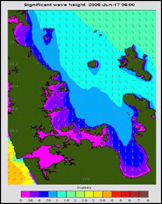
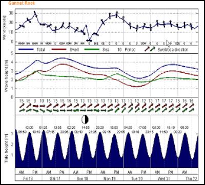
Marine forecasts are now available at an unprecedentedly localised level and detail thanks to a new web-based service from New Zealand oceanographic consultants, MetOcean Solutions Limited (www.metocean.co.nz). Local now really means local, with different forecasts possible for individual beaches, offshore installations or even, at the highest level of precision, wharves within a harbour basin. As for detail, forecasts now graphically provide, at a glance, 7 days wind, swell and wave data at regular intervals – with underlying data actually provided at hourly intervals.
For marine users brought up – and still dependent - on highly generalised forecasts, New Zealand truly is undergoing a revolution delivering operating efficiency and safety for commercial users, and safer and better recreation for the rest of us. Imagine commercial operators planning offshore work, or boat enthusiasts planning a trip a few days ahead. Conventional forecasts provide a broad guide to conditions say for the Hauraki Gulf or sea area from Raglan to Cape Egmont – but experience and intuition suggests conditions will vary vastly on many days within these regions. Tomorrow’s forecasts – now available across New Zealand – enable you to drill in to precise locations and take whatever action suits your. A conventional forecast directionally indicates changing conditions in a 24 hour period such as “Northwest 25 knots becoming southwest 20 knots early Saturday afternoon. Rough sea easing.” MetOcean forecasts provide an hour by hour view of how and when conditions are forecast to change with wind, wave and swell direction and data – all on the web and via twice daily e-mail. Water users will draw their own conclusions on the new opportunities to plan around the weather windows they need to have – or avoid; more efficient operations, more, safer or simply better time on the water, or simply the foresight to set your partner’s expectations!
Since the core forecast system was launched to selected ports, offshore oil & gas operators and strategic partners in October 2005, the system has proven itself time and again. In the recent west coast storms, users benefited from several days notice to plan time windows for cable laying operations or secure exposed equipment and infrastructure and were well prepared from the switch of a benign Sunday night sea to heavy Monday morning swells. Now all commercial operators can request customised forecasts for their operations through www.metocean.co.nz, or access any of 350 detailed, pre-determined locations at www.swellmap.com.
What is different with the MSL system to conventional forecasts is the ability to progressively forecast the marine conditions at increasingly finer scales. This allows for the effects on waves and winds of topographic and bathymetric features of the local and regional environment to be resolved. Put simply, the MSL forecast system collates the latest meteorological data and deep ocean wave spectral forecasts and simulates how waves will be altered, generated and transformed from interaction with the local wind and ocean floor. Using sophisticated computer modelling, the ocean conditions are forecast for the New Zealand region, and then progressively re-forecast for smaller and smaller areas to define the specified local conditions.
Whilst MetOcean is a home grown, kiwi solution, it is already developing the service for Australia and Indonesia, with active plans to extend to the Pacific Islands later in 2006.
About MetOcean Solutions Ltd
MetOcean Solutions Ltd (MSL) is an oceanographic and meteorological research, consulting and operational management application provider, dedicated to applying leading edge science for innovative client solutions. Highlights include:-
- New Zealand’s first national coverage, high-resolution commercial, maritime forecasting service, available to users over the web, 24/7.
- Arguably, the number 1 New Zealand provider of advanced MetOcean modelling to the offshore Oil & Gas industry.
- A world first in provision of very fine resolution, long-wave forecasting tools for port operational and safety planning.
- MSL have implemented NZs first dedicated data server for marine search and rescue and oil spill trajectory forecast modelling
MSL has a broad consulting and research background in oceanography and advanced modelling of the nearshore and continental shelf marine environment. In recent years, personnel have provided metocean field data, analysis and oceanographic support to numerous offshore engineering or coastal projects around NZ and overseas to ensure environmental or technical integrity, safety and/ or operating efficiency. Projects have considered; metocean data collection and analysis, seabed surveys, numerical modelling of waves, tides, currents and sediment transport, wave hindcasting and forecasting studies, oil-spill fate modelling and produced water discharges, beach and shoreline stability analysis, pipeline and cable seabed survey and stability analysis and wave kinematics, port and harbour wave penetration and agitation studies, development of metocean design criteria, ambient and extreme metocean statistics for operations and ocean engineering. MSL scientists have undertaken the environmental and design studies for all of the recent oil/gas developments in NZ, including oil spill trajectory modelling.
www.metocean.co.nz
ENDS
 Financial Markets Authority: FMA Seeks Clarity From High Court On Use Of Eligible Investor Certificates In Wholesale Investment Sector
 Scion: Scion’s Novel Internship Model Connects Talent With Industry
 Financial Markets Authority: Westpac Admits To Misleading Representations That Resulted In $6.35m In Overcharges
 Bill Bennett: Download Weekly - Review Of 2024
 Bill Bennett: One NZ scores worldwide first as Starlink direct-to-mobile launches
 Hugh Grant: How To Reduce Network Bottlenecks


