 Scoop has an Ethical Paywall


State of native forests revealed for first time
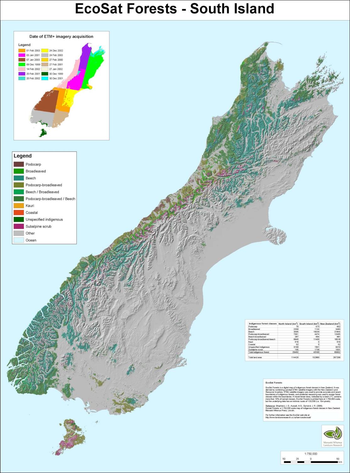
Stunning new maps, derived directly from satellite images, reveal that nearly a quarter of New Zealand’s land area is taken up by indigenous forest. Landcare Research’s EcoSat forest maps show native forests cover nearly 66,000 km2, 24.8% of the country. Beech forests are the most widespread, followed by podocarp-broadleaved forests, which include conifers such as rimu, totara and matai, and broadleaved trees like rata, tawa and rewarewa.
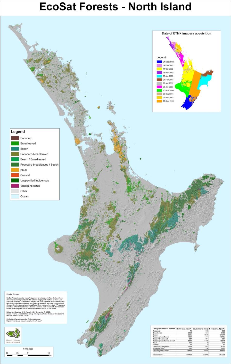
Click for big version
EcoSat "summary" maps of North Island and South Island (including Stewart Island) forests, at 1.750,000 scale.
Click for big
version
EcoSat maps have revealed that
indigenous forests make up almost a quarter of New Zealand's
land area.
EcoSat maps can be viewed in greater detail at: http://info.massey.landcareresearch.co.nz/client/john/
Exotic forest makes up 7.7% of our land area. Landcare Research scientist John Dymond says having a definitive nationwide measure means we will be able to tell if native forests are increasing or decreasing over time.
“This is crucial for those who need information on biodiversity and maintaining natural habitats. It is also important for monitoring New Zealand’s response to climate change targets through the amount of carbon dioxide being stored in indigenous trees.
“Additionally, district and regional councils want to monitor their policies on forest clearance, to make sure we are not losing what little remains of our precious lowland forests.” Mr Dymond says New Zealanders can take heart in the amount of native forest.
“It’s not as good as Germany’s 30% or Brazil’s 60%, but it compares well with the Netherlands’ 10% and the UK’s 8%.” Mr Dymond says he was surprised by some features of the maps.
“They underscore the loss of lowland forests nationwide. The east coast of the South Island is particularly denuded.
“Ecologists often talk of a ‘beech gap’, because beech is plentiful in the south and north of the South Island but is missing from the centre. Our maps show that east of the main divide in the centre of the South Island, where beeches would be expected, there is actually little of any sort of forest.”
“Also, in Coromandel there is much more kauri forest than in Northland.”
The EcoSat programme is a world-first achievement that makes satellite pictures easier to interpret. New Zealand’s often hilly terrain creates shadows, which makes computer interpretation of images slow and expensive. EcoSat “flattens” the effects of topography, so environmental features such as vegetation can be identified more easily.
The maps are available to a scale of 1:50,000, far more detailed than their nearest equivalent – maps at 1:1,000,000 produced 15 years ago. Summary maps at a 1:750,000 scale can be obtained from Landcare Research.
The satellite imagery for the maps was collected between 1999 and 2003. The maps will be updated in 2010.
 NZ Airports Association: Airlines And Airports Back Visa Simplification
 Netsafe: Statement From Netsafe About Proposed Social Media Ban
 The Reserve Bank of New Zealand: 2024 General Insurance Stress Test Results Published Today
  Worldline: School Holidays And Long Weekends Change Regional Spending Patterns In April
 Stats NZ: Livestock Numbers Fall Over The Last 10 Years While Area Planted In Fruit Increases
 Moths and Butterflies NZ Trust: Tagged Monarchs Found