A winter storm in summer
Media release From NIWA and GNS
Wednesday 25 February
2004

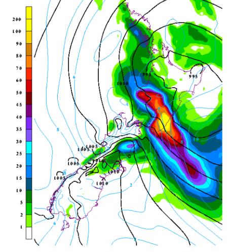
The 24 hour rainfall total up
until 9.00 a.m. on 16 February
The wild weather that saw parts of the lower North Island and top of the South Island under water last week had a definite touch of winter about it.
‘Last week’s weather pattern looked more like what you would expect to see in winter -or early spring. At this time of the year we might expect trouble from the tropics, but this event came roaring in from the southwest,’ said Warren Gray, joint coordinator of the NIWA and GNS National Hazards Centre.
However, unlike a wintertime storm, this system occurred when the air and seas were warmer, leading to a more vigorous system, with the warmer air able to hold more moisture.
‘The system was more pumped up than we would expect in a similar winter storm, and record rain and wind speeds were recorded,’ said Dr Gray.
NIWA has a research programme aimed at understanding these extreme weather systems. Below is a map of the 24-hour rainfall total up until 9.00 a.m. on 16 February 2004, as estimated by NIWA’s weather models. These models are detailed enough to be able to depict these weather events, and are being developed to predict the rainfall up to 72 hours ahead.
‘Our long-term goal is to improve the predictions of severe events, high river flows, and landslide risk,’ said Dr Gray.
NIWA and GNS are also investigating the likely social and economic effects of such hazardous events, and the latest Natural Hazards Update, published today, discusses the intense rainfall that caused the flooding in Paekakariki late last year.
Visit our website: www.naturalhazards.net.nz


 University of Auckland: Protecting Young Minds With AI
 Greenpeace: Greenpeace Calls On Fonterra Investors To Consider Big Picture With Giant Puzzle
 Hugh Grant: How New Tech Helps Kids Love Soccer More
 Bill Bennett: Download Weekly - 100% claim lands One New Zealand in criminal court action
 FSCL: Woman Scammed Out Of $25,000 After Job Offer On LinkedIn
 NIWA: Cheers To Crustaceans - New Species Named After Welly Brewery


