 Scoop has an Ethical Paywall


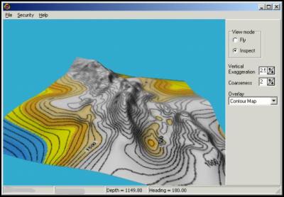
Flying Underwater To Reveal Deep Sea Terrain
The mysteries of underwater terrain are no longer hidden, thanks to revolutionary technology developed by an enterprising Nelson company.
Seabed Mapping International Ltd has just completed a year long research project which reveals, for the first time in graphic 3D, the topography of deep water fishing grounds and sends the resulting information direct to fishing vessels. The intellectual property management system for fishing companies will help in identifying prime fishing spots as well as reducing running and equipment costs.
It's already being used by at least one fishing company in New Zealand and keen interest is being shown in Chile, Japan, Spain, the UK and Australia, with early projections of doubling turnover in rapid time.
The 10 year old company has now formed an international division to manage its expansion off-shore and has already created two full time jobs, with a third on the way - a direct effect of the R&D programme which has led to a world first in seabed mapping.
Declan O'Toole, Seabed Mapping International’s CEO, says the company spent a 'significant amount' on the research, which was also assisted with part funding from the Foundation for Research, Science and Technology through Technology New Zealand.
He explains the theory behind the product; "What fishers need is very high resolution contour maps so they can get in the right spot. When you look at the costs to run a fishing vessel, around $25,000 a day, and the expensive gear which can be easily lost on the gnarly ocean floor, it's easy to see why they need as much information as possible on the deep water sea floor."
The company collected data automatically by boats while at sea and developed 3D viewing software which shows the seafloor in graphic format. This is encrypted for privacy and delivered digitally to the boats while at work.
"It's an exciting piece of software and it's superbly visual," says Mr O'Toole. "You can fly through the ocean floor and see all the contours - almost like a high speed low altitude aircraft. It’s great fun.”
"The whole exercise was very exciting and we got exciting new graphic software out of it," says Mr O'Toole. "It was a very positive experience; we had an easy time with Technology New Zealand and are building up a good relationship with our technology partner. I think the key was putting in hard work at the and concentrating on our planning
Tony Hadfield, of the Foundation for Research, Science and Technology, says the result could be of significant benefit to the fishing industry throughout New Zealand, as well as earning export dollars for the company.
"We like to see good positive results from companies leaping a technology hurdle," he says. "The fact that it has led directly to new job creation is a real bonus and we'd like to see more companies using R&D to do the same."
Technology New Zealand has around $36m available each year for technology development projects.
-ends-
 School Lunch Collective: Compass Group New Zealand To Acquire Libelle Group Securing Healthy School Lunch Programme
 PSA: PPPs Pose Risks To New Zealand Workers
 Office of the Privacy Commissioner: New Research Shows Business Leaders Fear Being On The Hook For Others’ Privacy Breaches
 E Tū: E Tū Members Send Open Letter To James Grenon And NZME Board
 Commerce Commission: Commission Calls For Comments On Copper Access Deregulation
 New Zealand Association of Scientists: NZAS Supports Saving Biotechnology Capacity In Callaghan; Asks What Now For Applied Technology Group


