 Scoop has an Ethical Paywall


Following 3 Major Quakes Off New Zealand, Questions Remain About How They Might Be Linked

Timothy
Stern, Te
Herenga Waka — Victoria University of
Wellington
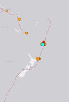
The
Tonga Kermadec subduction zone stretches between New Zealand
and south of Samoa.
USGS,
CC
BY-SA
A sequence of three major offshore earthquakes, including a magnitude 8.1 quake near the Kermadec Islands, triggered tsunami warnings and evacuations along the east coast of New Zealand on the morning of March 5.
By early afternoon, the National Emergency Management Agency (NEMA) lifted the evacuation order but stressed that people should stay off beaches and the shore.
All three earthquakes happened along the Tonga Kermadec subduction zone, where the Pacific tectonic plate dives under and then sinks beneath the Australian plate.
This subduction zone is the longest and deepest such system on Earth. It spans from just north of the East Cape, some 2600km to the north-east in an almost straight line to south of Samoa.
One of the questions seismologists around the world are now trying to answer is whether the three quakes were linked and the earlier ruptures triggered the magnitude 8.1 quake.
Potential links between ruptures
The Tonga Kermadec subduction zone terminates north-east of the East Cape, where it then becomes the Hikurangi subduction zone. The first 7.3 magnitude rupture struck at 2.27am, 174km off the east coast, where the Hikurangi and Tonga Kermadec systems merge.
The US Geological Survey recorded this event at a depth of 21km, not 95km deep as the first reports in New Zealand suggested. This quake had an unusual mechanism — an element of sideways movement known as strike-slip.
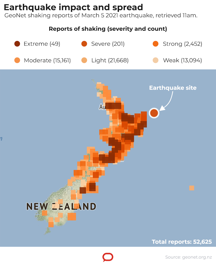
GeoNet.org.nz
(static edited by The Conversation), CC
BY-SA
The other two quakes were about 900km north, but just west of the Tonga-Kermadec trench and at depths of about 56km (for the 6.40am magnitude 7.4 event) and 20km (for the magnitude 8.1 quake at 8.28am). These later events had thrust, or compressive, mechanisms, in which one body of rock compresses against another, sliding up and over it during the earthquake.
This is what we might expect in a subduction zone where one tectonic plate is sliding under another and creating a collision, which in turn gives rise to compression.
As the Pacific plate starts to slide under the Australian plate, it starts off at a shallow angle and then turns along a curved trajectory to finally fall away at a very steep (60 degrees) angle. But when it’s at a shallow level, it is only dipping at say 10-20 degrees and creates a lot of friction with the overlying (Australian) plate. This is typically where these large earthquakes occur.
Triggering sequence
Magnitude 8 quakes in these subduction zone settings are not unusual. Indeed, quakes up to magnitude 9 can occur, such as Japan’s 2011 Tōhoku earthquake, the undersea earthquake off Sumatra that set off the 2004 Indian Ocean tsunami, and quakes in Alaska in 1964 and in Chile in 1960.
Read more:
Japan’s
experience with earthquakes can help teach us to learn to
live with floods
What is curious about this sequence offshore from New Zealand is whether or how the ruptures relate to each other. Certainly, the first of the two later quakes, located within tens of kilometres of each other, can be regarded as a foreshock, followed by the main magnitude 8.1 shock. But was the earliest 2.27am earthquake north of East Cape related?
Generally, seismologists regard a 1000km distance as too far for even a magnitude 7.4 rupture to disturb the ground enough to trigger another. But increasingly there are arguments that the Earth is critically stressed in plate boundary settings to such a level that just a small nudge can set off another event.
After the 2004 Sumatran quake, scientists made a good argument that it triggered further quakes an hour later, some 11,000km away in Alaska. But in this case, they were smaller events following a large triggering quake.
Read more:
A
new way to identify a rare type of earthquake in time to
issue lifesaving tsunami warnings
It’s also interesting that large earthquakes have happened off the Kermadec Islands in the past. In 1976, a magnitude 7.7 event was followed 51 minutes later by a magnitude 8 event. This mirrors what we saw today.
Both events in 1976 were thought to be thrust earthquakes like today’s shocks. Then in 1986, at a depth of 45km, a magnitude 7.7 event displayed both thrust and sideways strike-slip motion. The interpretation of this event was that it was not a plate interface event, but had happened within the subducted and bending Pacific plate.
This could explain the second earthquake this
morning, as its depth of 56km seems to place it within the
Pacific plate. We will need to wait until the final depths
and mechanisms are resolved.![]()
Timothy Stern, Professor of Geophysics, Te Herenga Waka — Victoria University of Wellington
This article is republished from The Conversation under a Creative Commons license. Read the original article.
 Binoy Kampmark: Concentrated Markets And Iceless Fokkers
 Binoy Kampmark: Catching Pegasus - Mercenary Spyware And The Liability Of The NSO Group
 Ramzy Baroud: The World Owes Palestine This Much - Please Stop Censoring Palestinian Voices
 Dee Ninis, The Conversation: Why Vanuatu Should Brace For Even More Aftershocks After This Week’s Deadly Quakes: A Seismologist Explains
 Martin LeFevre - Meditations: Meditation Without A Method
 Ramzy Baroud: Israel To Annex The West Bank – Why Now? And What Are The Likely Scenarios?