 Scoop has an Ethical Paywall


The Kaikoura Rebuild: A Scoop Foundation Investigation

Friday will be a big day for people north of Kaikōura – and for hundreds of construction workers who are racing to reopen State Highway 1 in time for the holiday season.
By the afternoon, the South Island’s main transport corridor will be open to traffic again, more than a year after a magnitude 7.8 earthquake mangled bridges and tunnels, twisted rail tracks and buried sections of the road under massive landslides.
Video of SH1 three weeks
before opening (NCTIR)
“The closure of the road was an incredibly difficult time for the people at the Clarence,” says Sue Murray, whose family farms the 12,800-hectare Bluff Station between the seaward and inland Kaikōura ranges, right on the Kekerengu Fault. For communities along this stretch, the earthquake turned everything into a mission – sending kids to school, seeing a doctor or a vet, even getting bulldozers in to help clear debris from landslips. A three-hour trip to Christchurch became a journey that took the best part of a day.
The Murrays had to transform an implements shed into impromptu accommodation for farm workers through the depth of winter. They lost farm tracks under massive slips that pounded into the valleys. Fixing quake-torn fences is an ongoing quest.
Opening day “will be huge for everybody”, but Sue Murray knows it is a milestone rather than the finishing line. Recovery work on the road is far from complete and the land is yet to settle down. “We can hear the rocks moving.”
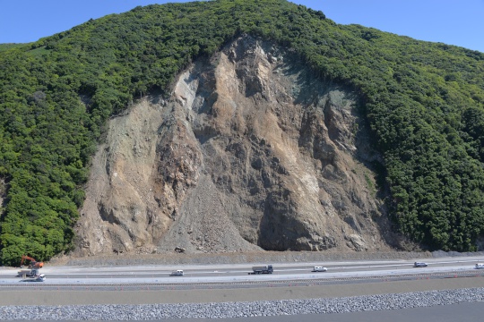
IMAGE: Landslide scar at
Mangamaunu (NCTIR)
In the top of the South Island, State Highway 1 is a delicate lifeline, wedged between the mountains and the sea. When last year’s quake ripped through, it ruptured more than 20 faults along its way across the land and into the ocean. It triggered almost 11,000 landslides, which dammed rivers and warped the landscape.
The number of landslides is not unusual. Compared with other shallow earthquakes of a similar magnitude, both in New Zealand and elsewhere, it is in fact much lower than expected, says Chris Massey, an engineering geologist at GNS Science who is assessing the hazard of future landslips for the North Canterbury Transport Infrastructure Recovery team, better known as NCTIR.
“The big problem now is that there is still a lot of debris hung up there. It’s not just the fact that the earthquake generated landslides and you’ve got debris sitting there. The earthquake also cracked the ground open and those cracks mean that the land is destabilised and that it will fail in future rain events and earthquakes at a lower threshold than it would have before the earthquake.”
This has been happening throughout the year. Cyclones Debbie and Cook, in March and April this year, brought rains that flooded and breached new dams inland and send debris flowing several kilometres downstream. Steep coastal cliffs north and south of Kaikōura also released new slips, shutting down already opened sections of the southern part of SH1. When I joined NCTIR’s road rebuild crews on a rainy day in October, the downpours demonstrated their power to loosen more mud from the slopes.
“After each major earthquake, rainfall-induced landslides will increase because the slopes are more susceptible; they are more fragile now,” Massey says. “Past weather events, such as cyclone Alice in 1975, triggered significant landslides. Now we’re getting landslides that are similar in volume after a rainstorm that has a two or one-year return period.”
Before last year’s quake, Massey says landslides triggered 24-hour closures along the northern corridor of SH1 between two or four times a year. He expects that to increase significantly. “It’s likely to be an order of magnitude more than what it was before, at least for the next few years until the slopes decay or until the next earthquake when you start a whole new crop of slopes that are ready to fail.”
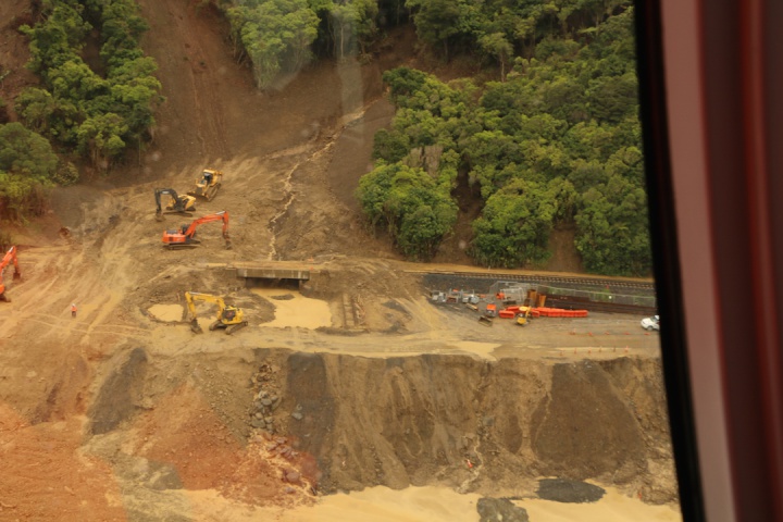
IMAGE: Debris bridge under construction, with new landslide triggered by rains in October (VMeduna)
NCTIR’s engineers are aware of the landslide hazard. Much of their work is focused on mitigating it, and it is one of the reasons the northern stretch of SH1 will remain closed at night, for now. There may also be pre-emptive closures whenever a storm is forecast, says Tim Crow, the New Zealand Transport Agency’s earthquake recovery manager. “Until we’ve got some history behind us, it’ll be precaution.”
The team has removed around a million cubic metres of rocks and mud from the old road north of Kaikōura. At Ohau Point, where the quake dumped one of the worst landslides, scars now stretch up to the ridgeline of the hills. Concrete seawalls hold up the new road and barriers provide a buffer against the hillside.
Just south of the point, at Half Moon Bay, debris bridges have been constructed to direct mud flows underneath the road and rail tracks where they can be cleared without disrupting traffic. Seawalls line sections of the road for hundreds of metres, assembled from thousands of five-tonne blocks of concrete that almost depleted New Zealand’s entire concrete supply.
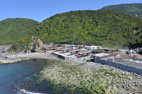
IMAGE: New seven-span bridge
over Irongate Stream moves the road onto the foreshore
(NCTIR)
At Irongate Stream, a 140-metre seven-span bridge has gone up in record time, moving the road out onto the foreshore and away from the slopes. “The objective is resilience,” says construction manager James Kelly. “We move cars away from the danger zone and create a buffer between them and the slips behind them. By elevating the road above the tide line, we’re also protecting it from sea level rise.”
For Ben Judge, who moved to the area some 20 years ago to run rafting trips down the Clarence, the road opening can’t come soon enough. He was on the river with a group when the earthquake struck. Thankfully, he had chosen a camp site that escaped serious damage. His favourite site was buried under a landslide that night.
The river itself has been reshaped, too. It’s forging a new path over a dam caused by a massive slip and it’s cutting a gorge into a slab of limestone that was uplifted by the Papatea fault, which runs through it.
But for Judge, the biggest impact has been on the logistics of getting rafters to the start of the trip. His company’s turnover dropped by more than half, and he’s not sure it would have survived without the government relief package for tourism ventures and the added income from NCTIR. Like many locals, he has found work as part of the recovery project. One of his buses was used as a taxi for road crews travelling between construction sites and a caravan park has sprung up on his rafting base to accommodate contractors.
On Sunday, he is expecting a group of rafters to arrive in Picton and he looks forward to taking them all the way to Kaikōura along SH1.
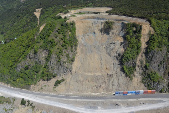
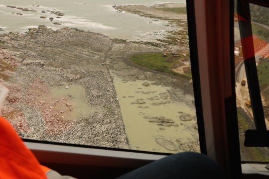
IMAGE: Waipapa Bay - one of
largest slips (NCTIR).
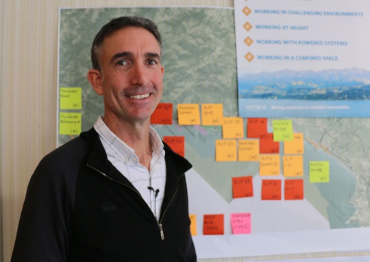
IMAGE: Brian Kirtlan -
operations manager (VMeduna)
Over the last year, about 1400 people have been employed by the road rebuild. Come early January, crews will be back to pick up the job again. “Traffic can flow through now, albeit in some places it will be single lane and unsealed,” says NCTIR operations manager Brian Kirtlan. “But we’ve identified 47 critical sites that represent a risk for the resilience of both road and rail and we’re investigating those now to see what’s needed. Next year and beyond, there’s still a significant amount of work to lift the resilience of the network overall. That’s going to give us greater comfort around future storm events and even smaller earthquakes.”
In areas that are prone to slips and along rail fences, monitoring devices are tracking for any movement. Cameras are beaming images back to a control centre in Kaikōura to provide a warning system for trains and road traffic. Next year, the teams will be adding more slope protection along the road north and south of the township, putting in catch fences and pinning down unstable rocks behind netting.
Would the road stand up to another big earthquake? “All the new structures that we put along the route are going to be engineered to the latest standards, which allow for earthquake loads,” says NZTA’s Tim Crow. “All the bridges and tunnel work will be a lot more resilient than the old tunnels and old bridges that didn’t survive so well. What we don’t know is what effect an earthquake could have on the landform generally. If there’s large uplift, you can’t engineer away from large displacements.”
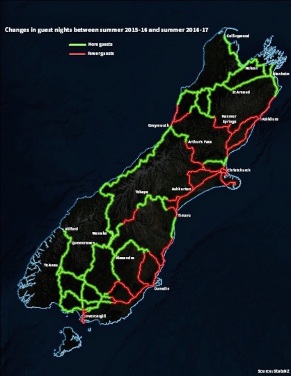
IMAGE: Changes in guest
nights, Kaikoura and South Island, STATS NZ
In Kaikōura itself, people in high-vis vests and 4WD trucks have replaced tourists and camper vans. Last summer was meant to be a bumper season for the town. Instead, it has gone through the equivalent of three winters.
During the month after the earthquake, guest nights dropped by 80% to their lowest level ever. By January, the town’s usual summer peak, they remained 61% below the previous year. In October, they matched previous years.
The town’s mayor, Winston Gray, is quietly optimistic that this summer will bring visitors back. He meets me in his office in the civic building, where his council moved less than a week before the earthquake. It stood up to it remarkably well – a symbol perhaps for the town’s recovery. He appreciates that the road crews have helped to keep some businesses afloat, but the severed road link meant that “4000 to 5000 vehicles a day were not coming through”.
One aspect of Kaikōura’s earthquake recovery that is in stark contrast to the experience of people in Canterbury is insurance. Although many people are still waiting to settle claims, 96% of all residential properties in the upper South Island, where most of the damage happened, had been assessed by the end of October. Almost 70% had been fully or partially settled. The chief executive of the Insurance Council of New Zealand, Tim Grafton, expects that by the end of the year well over 80% will have been settled.
“The Kaikoura response has been significantly different. Private insurers have acted as agents of EQC, settling both EQC and private insurer claims. This means insurers are dealing with their own customers and have clear visibility of the most damaged properties from the outset. By contrast, EQC has had responsibility for assessing and managing claims [following the Canterbury earthquakes], passing to private insurers over-cap claims for the most damaged properties. Settlements have been quicker for homeowners [affected by the Kaikoura earthquake], so they can move on with their lives.”
For Winston Gray, there’s even a silver lining. “For this council, the elephant in the room was erosion and foreshore protection, particularly around the urban area along the coastline here. That uplift has put that to bed for hopefully a couple of hundred years, probably longer.”
This is part one in a series by Veronika Meduna funded by the Scoop Foundation For Public Interest Journalism as part of an Earthquake Journalism Grant Round. For more information or to support further public interest journalism see the foundation page: https://foundation.scoop.co.nz/
This
grant enabled Veronika to travel to the affected area to get
a firsthand experience of the situation and even to take a
helicopter ride and take these amazing
photos:
To support further public interest journalism projects like this you can make a one-off or recurring donation to the Scoop Foundation via PressPatron here.
 Richard S. Ehrlich: Deadly Border Feud Between Thailand & Cambodia
 Gordon Campbell: On Free Speech And Anti-Semitism
 Ian Powell: The Disgrace Of The Hospice Care Funding Scandal
 Binoy Kampmark: Catching Israel Out - Gaza And The Madleen “Selfie” Protest
 Ramzy Baroud: Gaza's 'Humanitarian' Façade - A Deceptive Ploy Unravels
 Keith Rankin: Remembering New Zealand's Missing Tragedy