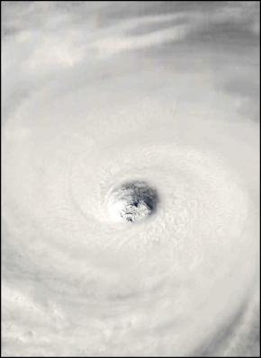
The Eye Of Hurricane Rita In The Gulf Of Mexico – source: NASA MODIS
Click for big version
Supercomputer Weather: Hurricane Rita's Landfall Forecast
Compiled by Alastair Thompson
Useful Links:
National
Hurricane Warning Center
Weather Underground – Tropical
Google Map of the Texas Coast
Google Map (Satellite Imagery)– Texas
Coast
Google News – "Hurricane
Rita"
Hurricane Rita, downgraded presently to a Category 4 Hurricane – but forecast to intensify over the coming 12 hours, remains on track to plough directly into the most densely populated stretch of the Texas coast in roughly 30 hours time (click for super computer forecast of landfall).
Meanwhile the evacuation of Houston is not going at all well with thousands of cars stranded on the interstate highways headed out of the city. Already emergency management officials are talking about erecting hurricane shelters on the sides of the highway.
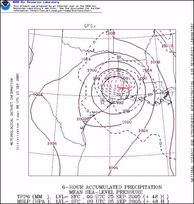
Adding to the heightening level of concern is the fact that the latest series of weather forecasts show Hurricane Rita stalling after it crosses the Texas Coast, bringing torrential rains over an extended period to much of the state.
Hurricane Rita is also forecast to pass directly through an area of ocean going oil rigs and close enough to dozens of oil refineries to potentially slash the United States total oil refining capacity. In the process Hurricane Rita is likely to drive up the global price of oil and petroleum products.
In the interactive map linked below oil rigs, fixed and mobile, are plotted alongside the projected path of Hurricane Rita. The most intense winds in the hurricane are in the North East quadrant.
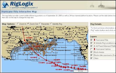
Click RigLogix Hurricane Rita Interactive Map
In the images below the scale of the central most destructive portion of Hurricane Rita can be easily compared to the Houston/Galveston urban area. Each image is on the same scale and it is fairly easy to imagine the hurricane superimposed on top of the satellite image of Houston/Galveston.
While the eye of Hurricane Rita is forecast to pass between Houston and the Louisiana border, as you can see in the images below, the most intense winds in the hurricane, near the eye wall, are then likely to pass directly through Houston to the west and a group of oil refineries close to the Louisiana Border to the east.

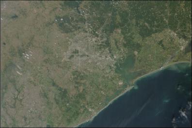
Click images for big versions
The above two images are closeup portions of the image below.
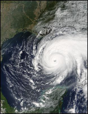
Hurricane Rita In The Gulf Of Mexico – source: NASA MODIS
Click for big version
NATIONAL HURRICANE CENTER FORECAST
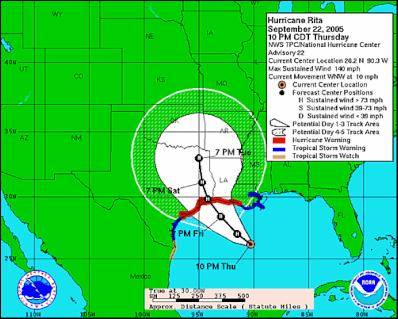
Tracking Map For Hurricane Rita – National Hurricane Center
Click for big version
Click For Latest Tracking Map from National Hurricane Center
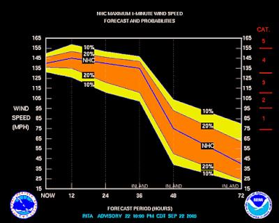
Intensity Forecast
For Hurricane Rita – National Hurricane
Center
Click for big version
Click For Latest Tracking Map from National
Hurricane Center
Click For Latest Hurricane Discussion – National Hurricane Center
000 WTNT43 KNHC 230304 TCDAT3
HURRICANE RITA DISCUSSION NUMBER 22
NWS TPC/NATIONAL HURRICANE CENTER
MIAMI FL
11 PM EDT THU SEP 22 2005FLIGHT LEVEL WIND DATA AND RADAR OBSERVATIONS FROM THE AIR FORCE HURRICANE HUNTER AIRCRAFT INDICATE THAT THE CONCENTRIC EYEWALL CYCLE MIGHT BE NEARING COMPLETION. THERE IS NOW ONLY A SINGLE FLIGHT LEVEL WIND MAXIMUM AT A RADIUS OF ABOUT 20 N MI...ASSOCIATED WITH THE OUTER EYEWALL THAT THE AIRCRAFT RADAR INDICATE IS SLOWLY CONTRACTING... WHILE THE INNER EYEWALL CONTINUES TO DETERIORATE. RECENT GOES INFRARED IMAGERY ALSO INDICATES THAT A COMPLETE RING OF VERY COLD CONVECTIVE TOPS...COLDER THAN -70C... NOW SURROUNDS THE EYE. THE CENTRAL PRESSURE HAS ONLY RISEN SLIGHTLY TO 917 MB AS MEASURED BY THE MOST RECENT DROPSONDE. RECENT FLIGHT LEVEL AND DROPSONDE WIND DATA DO NOT SUPPORT AN INTENSITY GREATER THAN ABOUT 110 KT...BUT GIVEN THE VERY LOW PRESSURE...THE INITIAL INTENSITY IS ADJUSTED ONLY SLIGHTLY DOWNWARD TO 120 KT. RITA IS ABOUT TO PASS OVER ANOTHER EDDY OF HIGH OCEAN HEAT CONTENT. COMBINING THIS WITH THE POSSIBLE CONTRACTION OF THE OUTER EYEWALL DURING THE NEXT SEVERAL HOURS...SOME RESTRENGTHENING IS FORECAST IN THE SHORT TERM. GRADUAL WEAKENING IS POSSIBLE LATER ON FRIDAY BEFORE LANDFALL DUE TO LESSER OCEAN HEAT CONTENT CLOSER TO THE COAST...AND TO THE POSSIBILITY OF SOME INCREASE IN THE WIND SHEAR. THE BOTTOM LINE IS THAT THE INTENSITY WILL LIKELY FLUCTUATE DURING THE NEXT 36 HOURS...AND RITA IS EXPECTED TO MAKE LANDFALL AS A MAJOR HURRICANE...AT LEAST CATEGORY THREE.
ALTHOUGH RITA HAS WOBBLED WESTWARD DURING THE PAST COUPLE OF HOURS...THE OVERALL MOTION DURING THE PAST SEVERAL HOURS HAS REMAINED WEST-NORTHWESTWARD...ABOUT 300/9. THERE ARE NO CHANGES TO THE OFFICIAL TRACK FORECAST...SINCE THE VARIOUS DYNAMICAL MODELS STRADDLE THE PREVIOUS ADVISORY TRACK. RITA IS EXPECTED TO GRADUALLY TURN NORTHWESTWARD AND EVENTUALLY NORTHWARD AS THE HIGH TO ITS NORTH SLIDES EASTWARD. RITA IS FORECAST TO THEN ESSENTIALLY STALL IN ABOUT THREE DAYS IN THE AREA OF NORTHEASTERN TEXAS WHERE STEERING CURRENTS ARE FORECAST TO BECOME VERY WEAK. THIS SCENARIO POSES A GREAT RISK OF VERY HEAVY RAINFALL WELL INLAND AND FOR MANY DAYS AFTER LANDFALL.
FORECASTER KNABB
FORECAST POSITIONS AND MAX WINDSINITIAL 23/0300Z 26.2N 90.3W 120 KT
12HR VT 23/1200Z 27.0N 91.5W 125 KT
24HR VT 24/0000Z 28.4N 93.0W 120 KT
36HR VT 24/1200Z 29.8N 94.2W 115 KT...INLAND
48HR VT 25/0000Z 31.1N 94.7W 65 KT...INLAND
72HR VT 26/0000Z 33.0N 95.0W 35 KT...INLAND
96HR VT 27/0000Z 33.0N 95.0W 25 KT...INLAND
120HR VT 28/0000Z 33.0N 95.0W 25 KT...INLAND
$$
LATEST SUPERCOMPUTER LANDFALL FORECAST
+24
Hrs…
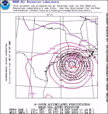
+30 Hrs…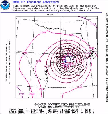
+36 Hrs…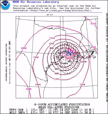
Click for big
version
POST LAND FALL SUPERCOMPUTER FORECAST
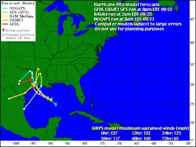
Weather Underground Computer Model Tracking Map – Hurricane Rita
Click for big version
+48 Hrs…
+60 Hrs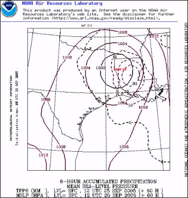
+72 Hrs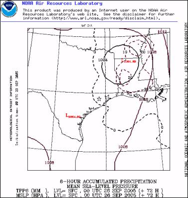


 Martin LeFevre - Meditations: Psychedelics, Mystical Experiencing, And Organized Religion
 Keith Rankin: Equity Rights - UBI, SUI, BUI, HUI, Or GUI?
 Binoy Kampmark: The Inevitable Souring - Elon Musk Falls Out With Donald Trump
 Ian Powell: Postscript On Ethnic Cleansing, Genocide And New Zealand Recognition Of Palestine
 Gordon Campbell: On Why Leakers Are Essential To The Public Good
 Ramzy Baroud: Global Backlash - How The World Could Shift Israel's Gaza Strategy