 Scoop has an Ethical Paywall


Super Computer Weather: Isabel Nears US East Coast
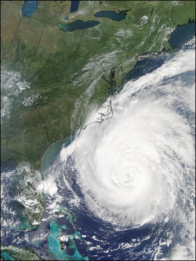
Click Image For Big Version
Source NASA - 2003/260 - 09/17 at 18 :24 UTC - Satellite: Aqua
As the image above shows the cloud formations on the edges of Hurricane Isabel are now over the US mainland. The eye of Isabel is following roughly 30 hours behind these fringes – with landfall expected 2pm Thursday EST (Friday Morning NZT). A massive evacuation is presently underway in affected regions.
The hurricane's winds have declined to category two level which, while still dangerous, are considerably lower than the 200kmh + winds Isabel packed at the weekend when still a category five storm. The worst of Isabel is now xpected in the form of floods.
Already this month North Carolina and Virginia have experienced unusually high rainfalls, rivers are high and the ground is waterlogged throughout much of the area expected to bear the brunt of Isabel. The NOAA GFS supercomputer model forecasts below show well in excess of 200mm of rain can be expected over a wide area in both North Carolina and Virginia. Maryland and Washington DC can probably also expect flooding.
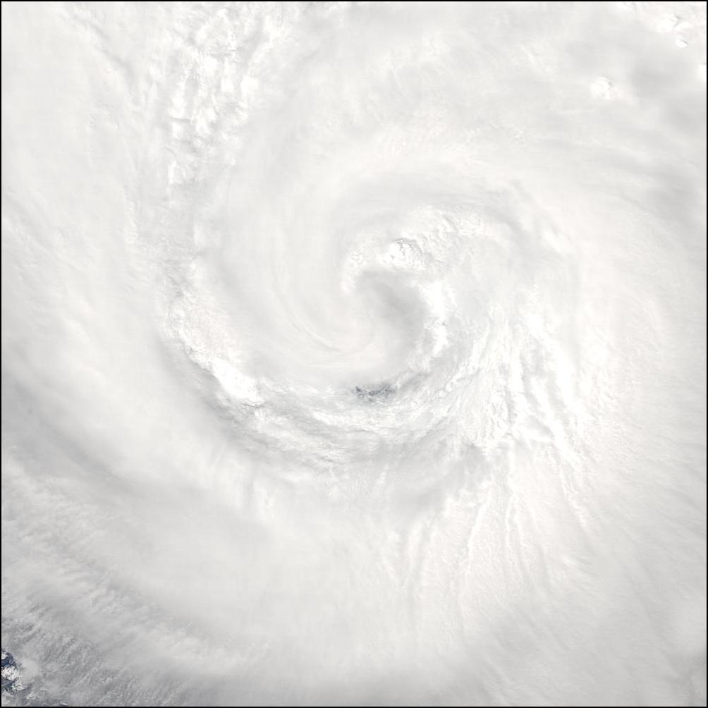
Click Image For Big Version
Source NASA - 2003/257 - 09/14 at 14 :45 UTC - Satellite: Terra
Latest National Hurricane Center Forecast Path & Discussion
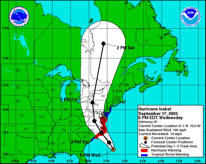
Graphic From:
National Hurricane Center
000
WTNT43 KNHC 172052
TCDAT3
HURRICANE ISABEL DISCUSSION NUMBER 47
NWS TPC/NATIONAL HURRICANE CENTER MIAMI FL
5 PM EDT WED SEP 17 2003IF FLIGHT-LEVEL OBSERVATIONS WERE ALL WE HAD...ISABEL WOULD BE A CATEGORY THREE HURRICANE. THE HURRICANE HUNTER AIRCRAFT THIS AFTERNOON FOUND A NUMBER OF SPOTS OF WINDS OF 110-120 KT. THIS WOULD NORMALLY CORRESPOND TO SURFACE WINDS OF 100-105 KT. HOWEVER...NUMEROUS DROPSONDE PROFILES IN THE HIGH WIND REGIONS OF THE CIRCULATION SHOW A CONSISTENT AND UNUSUALLY STEEP FALL-OFF OF WIND IN THE BOUNDARY LAYER. THIS IS CONSISTENT WITH THE MEAGER CONVECTION IN THE HURRICANE CORE. BASED ON THESE PROFILES...THE INITIAL INTENSITY IS SET AT 90 KT. THE UPPER-LEVEL OUTFLOW PATTERN HAS BECOME FAVORABLE...AS WAS FORECAST BY THE GLOBAL MODELS...AND IN FACT THE CIRCULATION ALOFT IS STRENGTHENING. HOWEVER... THERMODYANAMIC FACTORS ARE LIMITING THE ABILITY OF ISABEL TO COMPLETELY RESPOND TO THE FAVORABLE UPPER-LEVEL FORCING. THE OFFICIAL FORECAST DOES NOT ANTICIPATE ANY SIGNIFICANT INCREASE IN STRENGTH PRIOR TO LANDFALL...BUT SHOULD THERE BE A SUBSTANTIAL INCREASE IN DEEP CONVECTION ISABEL COULD QUICKLY REACH CATEGORY THREE STATUS.
ONCE AGAIN...THERE HAS BEEN NO SIGNIFICANT CHANGE TO THE TRACK FORECAST OR REASONING. THE LATEST RUN OF THE GFS IS A LITTLE FASTER AND SLIGHTLY TO THE RIGHT OF THE PREVIOUS RUN...BUT THE GUIDANCE REMAINS IN EXCELLENT AGREEMENT. THE INITIAL MOTION IS NOW 330/12 AS ISABEL BEGINS A MODEST ACCELERATION TOWARD THE COAST. SOME ADDITIONAL ACCELERATION IS STILL EXPECTED PRIOR TO LANDFALL.
ISABEL HAS A LARGE CIRCULATION...INCLUDING A LARGE EXTENT OF DAMAGING WINDS. THEREFORE...IT IS ESPECIALLY IMPORTANT NOT TO FOCUS ON THE PRECISE LANDFALL LOCATION...SINCE SIGNIFICANT IMPACTS WILL BE FELT AT LARGE DISTANCES FROM THE LANDFALL POINT.
FORECASTER FRANKLIN
FORECAST POSITIONS AND MAX WINDS
INITIAL 17/2100Z 31.1N 73.3W 90 KT
12HR VT 18/0600Z 32.7N 74.4W 95 KT
24HR VT 18/1800Z 35.0N 76.6W 95 KT...INLAND
36HR VT 19/0600Z 37.6N 78.5W 60 KT...INLAND
48HR VT 19/1800Z 41.5N 79.0W 40 KT...INLAND
72HR VT 20/1800Z 52.5N 76.0W 30 KT...EXTRATROPICAL
96HR VT 21/1800Z...ABSORBED BY EXTRATROPICAL LOW
- SOURCE: National Hurricane Center
NOTE: Each picture shows rainfall and isobars. Each forecast image shows rainfall forecast over a six hour period.
+18 Hours
+24 Hours
+30 Hours
CLICK FOR BIG VERSION
+36 Hours
+42 Hours
+48 Hours
 Binoy Kampmark: Bratty Royal - Prince Harry And Bespoke Security Protection
 Keith Rankin: Make Deficits Great Again - Maintaining A Pragmatic Balance
 Richard S. Ehrlich: China's Great Wall & Egypt's Pyramids
 Gordon Campbell: On Surviving Trump’s Trip To La La Land
 Ramzy Baroud: Famine In Gaza - Will We Continue To Watch As Gaza Starves To Death?
 Peter Dunne: Dunne's Weekly - A Government Backbencher's Lot Not Always A Happy One