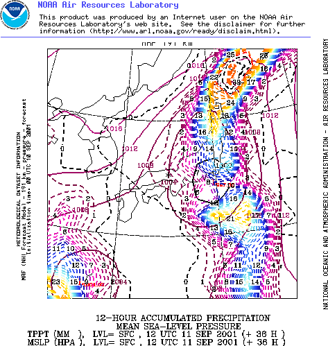
The above forecast image from the NOAA supercomputer weather model shows the arrival of Typhoon Danas in downtown Tokyo on Thursday.
And according to the NOAA medium range forecast, Tokyo, which has been struck by only two typhoons in the last two decades, is facing the prospects of being battered by three typhoons in the space of a single month.
Typhoon Danas is weaker than typhoon Pabuk (see… Destination Tokyo For Typhoon Pabuk, Sludge Report #103 - A Perfect Storm For Kyoto and Typhoon Pabuk Lands, Heads For Tokyo ) which hit the Japanese capital late last month and killed several people during its passage over the Japanese mainland.
See the
following links for detail of the forecast path of Typhoon
Danas:
+12 Hours
http://img.scoop.co.nz/stories/images/weather/japantyphoon/danas12hrs.gif
+24
Hours
http://img.scoop.co.nz/stories/images/weather/japantyphoon/danas24hrs.gif
+36 Hours
http://img.scoop.co.nz/stories/images/weather/japantyphoon/danas36hrs.gif
+48 Hours
http://img.scoop.co.nz/stories/images/weather/japantyphoon/danas48hrs.gif
See
also the Joint Typhoon Warning Centre’s forecast path for
Danas:
http://www.npmoc.navy.mil/products/jtwc/wp1901.gif
However, while Danas may be weakening and will soon have crossed Japan heading north, another typhoon, Nari, is already gathering strength over the sea near the island of Okinawa, and is threatening to wreck considerable damage on the Japanese Islands this coming weekend.

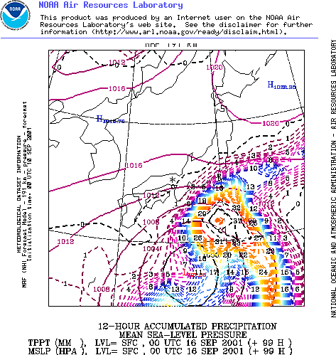
By Saturday, according to the NOAA supercomputer weather model, Typhoon Nari will have reached hurricane intensity, and its outer edges will be approaching Tokyo as the above image shows.
The current NOAA forecast path for Typhoon Nari shows it passing the Japanese islands to the south, heading east.
See the following links for detail of the forecast
path of Typhoon Nari:
September 15th
http://img.scoop.co.nz/stories/images/weather/japantyphoon/typhoon2015th.gif
September
16th
http://img.scoop.co.nz/stories/images/weather/japantyphoon/typhoon2016th.gif
September
17th
http://img.scoop.co.nz/stories/images/weather/japantyphoon/typhoon2017th.gif
September
18th
http://img.scoop.co.nz/stories/images/weather/japantyphoon/typhoon2018th.gif
See
also the Joint Typhoon Warning Centre’s forecast path for
Nari:
http://www.npmoc.navy.mil/products/jtwc/wp2001.gif
However typhoons and hurricanes are notoriously unpredictable in their paths, and in earlier forecasts for this storm NOAA has placed Tokyo in its direct path. It is also worth noting that most computer forecast models initially predicted that both Pabuk and Danas would pass by to the South of Japan.
For a live reading on the status of these typhoons and any others around the globe see the excellent resources at…
The University of Wisconsin
http://cimss.ssec.wisc.edu/tropic/
and…
The Joint
Typhoon Warning Centre
http://www.npmoc.navy.mil/jtwc.html


 DC Harding: In The Spirit Of Natural Justice
 Martin LeFevre - Meditations: Animal Encounters During Meditative States
 Ian Powell: Gisborne Hospital Senior Doctors Strike Highlights Important Health System Issues
 Keith Rankin: Who, Neither Politician Nor Monarch, Executed 100,000 Civilians In A Single Night?
 Eugene Doyle: Writing In The Time Of Genocide
 Gordon Campbell: On Wealth Taxes And Capital Flight