In this edition: Bullseye D.C. - Is This What Cold War Looks Like?
NOTE: Authors of this report will be anonymous and wide ranging. Indeed you are invited to contribute: The format is as a reporters notebook. It will be published as and when material is available. C.D. Sludge can be contacted at sludge@scoop.co.nz. The Sludge Report is available as a free email service..Click HERE - http://www.scoop.co.nz/mason/myscoop/ to subscribe...
Sludge Report #48
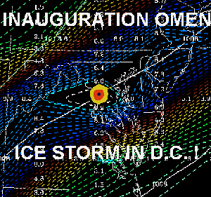
Bullseye D.C.
 http://img.scoop.co.nz/stories/images/InaugurationChill/bullseye.gif
Is This What Cold War Looks Like?
It appears the NOAA Supercomputer’s long range forecast for Inauguration Day in Washington D.C., first published by Scoop on Monday (see... Icy Blast For Bush’s Inauguration [1]), and then again Wednesday (see... Storm Warning For Dubya [2] ), were right on the button.
Links:
[1] http://www.scoop.co.nz/mason/stories/HL0101/S00011.htm
[2]
http://www.scoop.co.nz/mason/stories/HL0101/S00025.htm
With
only 30 hours to go till George Walker Bush assumes the
mantle of President of the United States the short-range
NOAA Aviation weather model shows a direct hit on Washington
by the eye of a nasty storm. And at this range the
supercomputer weather model is extremely accurate.

http://img.scoop.co.nz/stories/images/InaugurationChill/wash20rain1.gif
In the image above the storm is showed centred on D.C. in the early hours of January 20th, Inauguration Day for the 43rd President of the United States of America.
The computer forecast is the worst yet for the US Capital showing Inauguration Day in D.C as positively dangerous. Northerly winds from 10 to 20 knots. Temperatures close to zero centigrade (freezing point), and falling, and around 30mm of rain/snow over the 24 hours till midday Washington D.C. time by which time the temperature (including the windchill factor) will be well below zero and falling.
With the combination of heavy rain and snow, and the freezing northerly moving in, the danger of the storm leaving D.C. encased in ice – and basically locked down - for the President-Elect’s party-of-a-lifetime is now a distinct possibility.
Links To NOAA Supercomputer Weather Images (Note: In all images Washington D.C is positioned in the centre of the frame )
Rain Over Six Hourly Periods:
Midnight
http://img.scoop.co.nz/stories/images/InaugurationChill/wash20rain1.gif
6am
http://img.scoop.co.nz/stories/images/InaugurationChill/wash20rain2.gif
12pm
http://img.scoop.co.nz/stories/images/InaugurationChill/wash20rain3.gif
Temperature
Degrees Centigrade:
Midnight
http://img.scoop.co.nz/stories/images/InaugurationChill/wash20temp1.gif
6am
http://img.scoop.co.nz/stories/images/InaugurationChill/wash20temp2.gif
12pm
http://img.scoop.co.nz/stories/images/InaugurationChill/wash20temp3.gif
6pm
http://img.scoop.co.nz/stories/images/InaugurationChill/wash20temp4.gif
Anti(c)opyright
Sludge
2001


 Eugene Doyle: The Fall Of Saigon 1975 - Fifty Years Of Repeating What Was Forgotten
 Peter Dunne: Dunne's Weekly - Trump's Tariffs Still Pose Risks For New Zealand
 Keith Rankin: Barbecued Hamburgers And Churchill's Bestie
 Gordon Campbell: On Why The US Stands To Lose The Tariff Wars
 Eugene Doyle: Before It’s Too Late - Reimagine New Zealand’s Military Future
  Binoy Kampmark: Gender Stunts In Space - Blue Origin’s Female Celebrity Envoys