 Scoop has an Ethical Paywall


UC investigating if drones can be used to help fight fires
University of Canterbury investigating if drones can be used to help fight fires
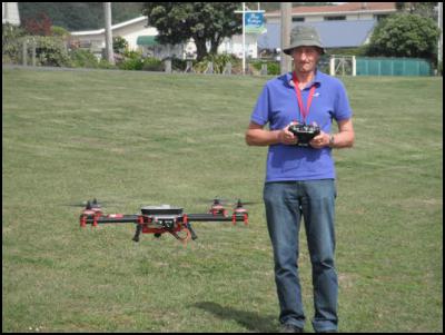
Kelvin Barnsdale launching a University of Canterbury UAV.
The University of Canterbury’s Spatial Engineering Research Centre (SERC) is investigating the possibility of using unmanned aerial vehicles (UAVs) or drones to help fight fires.
The investigation is sponsored by SCION, a Crown Research Institute which is dedicated to improving the international competitiveness of New Zealand forestry.
At least 10 helicopters have been called in to fight a fire that has spread across 330ha of the Southern Alps which forcing the closure of State Highway 73.
Final year University of Canterbury electrical engineering student Ben Litchfield is working on the project under the supervision of SERC’s senior research engineer Kelvin Barnsdale.
A rural fire can continue to burn underground long after it has ceased burning on the surface. These underground hotspots can restart a fire and need to be extinguished by fire fighters. Existing methods for finding these hotspots involves either time intensive manual searching by teams of fire fighters or the use of a helicopter fitted with a thermal camera.
“My project aims to utilise UAVs armed with thermal cameras to quickly and cost effectively map the burned area and provide precise GPS coordinates of all hotspots,” Litchfield says.
“Spotting hotspots from helicopters can cost up to $5000 a day. The UAV used in the project is a quad copter and has a flight time of about 15 minutes.
“The quad copter is fitted with a gyroscopically stabilised high end thermal camera and GPS equipment. A small on board computer stores each image captured by the thermal camera along with its matching GPS co-ordinate.
“Hot spots at the edges of burnt areas as these have the highest chance of re-igniting due to proximity to fuel. The long term goal is for the small quadcopter to automatically detect and follow the edges of the burned area while noting the GPS co-ordinates of any hotspots it detects.
“This information would then be passed to fire crew as an accurate map of the hotspots in the area. We plan to visit any rural fire next month to test capabilities of the current prototype. Initial field testing has shown very positive results,” Litchfield says.
The university’s Spatial Engineering Research Centre provides expertise for the science and technology behind UAVs and the over-arching Wireless Research Centre provides world-class knowledge on wireless communications, ultimately allowing real time, high quality transfer of information from a UAV to a command centre when there is a need.
ENDS
 NZ Principals Federation: Principals Honour The Legacy Of Angus Hikairo Macfarlane (CNZM)
 National Library Of NZ: Nominations Open For Te Awhi Rito Reading Ambassador
 Maori Sports Awards: Indigenous Sports Awards Showcases Māori Olympic Success
 Health Coalition Aotearoa: National Prevention Service Cuts - A Body-Blow To Health
 Queer Endurance in Defiance: Statement On The Proposed Restriction Of Puberty Blockers
 NZ Olympic Committee: Nigel Avery Named NZ Team Chef de Mission For Glasgow 2026 Commonwealth Games And LA 2028 Olympic Games