Historical Turnbull Maps Now Online
Historical Turnbull Maps Now Online

Click to enlarge
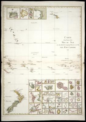
Laborde, M. de (Jean-Benjamin), 1734-1794. Carte d'une partie de la Mer du Sud avec des details sur les principles isles de cette mer [map]. Scale [ca. 1:11 000 000]. ([Paris]: M. De Laborde, 1791). 84 x 62 cm. Cartographic Collection, Alexander Turnbull Library.
MEDIA RELEASE
For immediate
release
6 June 2006
HISTORICAL TURNBULL MAPS NOW ONLINE
The Alexander Turnbull Library has linked some 240 images of historical New Zealand maps from its collections to the National Library Catalogue (http://nlnzcat.natlib.govt.nz).
The maps and charts, dated from 1587 to the 1980s, are mostly of the Pacific and New Zealand and cover many subjects, including land wars, land ownership, settlement and exploration. Through ongoing digitisation programs and projects, the collection will grow over time and provide improved access to the Turnbull's 60,000 plus map collection.
The online maps are available in low-resolution JPEG files at this stage. The Library is working towards providing access to higher-resolution images online in the future. All map images can be purchased at high resolution and can be provided on CD or DVD.
To access a map, follow these steps: Log on to the National Library Catalogue (http://nlnzcat.natlib.govt.nz or click on Search catalogues and databases on the National Library website (www.natlib.govt.nz). Put the words MapColl digital in the search box. Scroll down to Call number (begins with) in the box marked 'Using'. Click the Search button. This will bring up all the map records. Click on a record, go to the bottom of the page and click on Link to digital copy. This will bring up a picture of the map.
Images of unpublished maps are available on Timeframes (http://timeframes.natlib.govt.nz)
ENDS


 Rachelle Martin & Kaaren Mathias, The Conversation: 1 In 6 New Zealanders Is Disabled. Why Does So Much Health Research Still Exclude Them?
 Athletics New Zealand: Connor Bell Breaks NZ Discus Record (Again)
 Tertiary Education Union: UCOL Cuts Will Cause Lasting Damage
 National Library Of New Zealand: Kate De Goldi Named Te Awhi Rito Reading Ambassador For Aotearoa
 Hikoi for Health: Healthcare Crisis Drives Cross-Country Protest | Hīkoi For Health Set To Begin
 University of Auckland: New Zealand Professor's Paper Is One Of Century's Most-Cited