 Scoop has an Ethical Paywall


Rain For Some But Settled Weather Returns Next Week
Covering period of Thu 18 - Mon 22 April
The weather has been mostly fine across Aotearoa New Zealand, however, MetService forecasts a burst of rain on Saturday, before a large area of high pressure brings another run of settled weather as we move into next week.
A cold front approaches the south of the South Island on Friday. Blustery northwesterly winds precede the arrival of rain in the south and west, however, by the end of the day the front weakens leaving areas north of Christchurch mostly dry. For the North Island passing showers are possible in most areas, with Horowhenua, Wellington and the east coast looking to remain dry.
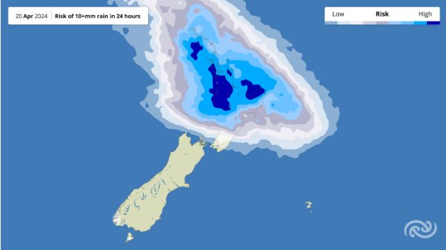
A low pressure system approaching from the Tasman Sea is forecast to bring rain to a large portion of the North Island, leaving most of the South Island remaining dry on Saturday.
MetService meteorologist Lewis Ferris states, “the weather models have different ideas about the extent and intensity of the incoming rain, so keep an eye on the forecast for Saturday if you are making outdoors plans.”
Areas north of Taranaki to Napier are most likely to see rain on Saturday with the potential for some heavy falls in the mix. The further south, the less likely rain becomes, but there is risk the wet weather will reach as far south as Wellington and the top of the South Island.
On Sunday the low pressure system moves away to the east which means clearer weather across the country. However, southerlies and showers are possible around Hawke’s Bay and Gisborne, while westerly winds bring showers to the south and west of the South Island.
As we enter the new working week high pressure moves in across the country, forecast to bring a settled run of weather. While this will be a good chance for parents to get the kids outdoors, there’s potential the weather will turn as we head towards ANZAC Day.
 Gordon Campbell: On The Left’s Electability Crisis, And The Abundance Ecotopia
 NZ Police: New Zealand Police team up with Z Energy, NZTA and ACC to remind Kiwis to drive safe this Easter
 NZCAST: NZCAST Leads Ongoing Cross-Agency Collaboration To Break Down Barriers For Survivors Of State Abuse
 Regional and Unitary Councils Aotearoa: Regional And Unitary Councils Back A Practical FWFP System
 NZ Government: Stay Safe On Our Roads This Easter
 YWCA: Global Push Back Against Gender Equality A Growing Crisis In Aotearoa
 Te Pāti Māori: Ngarewa-Packer - Fast-Tracking Seabed Mining Ignores Māori Opposition And Environmental Precedent