 Scoop has an Ethical Paywall


Wet And Windy Until Saturday, Then Mostly Sunny For Waitangi Day
Covering period
of Thursday 01 - Tuesday 06
February
The atmosphere is going to have a weekend like a festival-goer – wild on Friday and Saturday but worn out and sedate by Sunday. MetService is forecasting a strong cold front to reach the southwest tonight (Thursday) and move quickly across Aotearoa New Zealand on Friday and Saturday, before a ridge of high pressure arrives on Sunday.
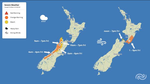
MetService meteorologist Alain Baillie says, “The front will bring further heavy rain to the South Island’s West Coast. Orange Heavy Rain Warnings have been issued for the Westland, Grey and Buller Ranges during Friday, with Watches for western Tasman and the Nelson Lakes, and the headwaters of rivers in North Canterbury.”
“Keep an eye on the MetService Warnings page for updates as the situation unfolds.”, Alain says.
The western South Island received well above average rainfall in January; Milford Sound recorded 1006mm (average 647mm), Haast received 449mm (248mm) and Hokitika 359mm (212mm).
Baillie continues, “By Friday afternoon, northwesterly winds ahead of the front are forecast to reach severe gale in central areas of Aotearoa New Zealand, with gusts of 120 km/h in exposed parts of Wellington and Wairarapa.”
An Orange Strong Wind Warning for those areas runs from 1pm to 9pm on Friday, with a Watch for the Marlborough Sounds from noon to 7pm Friday.
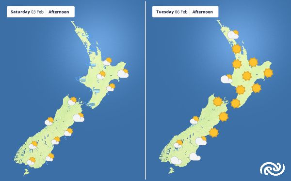
“Saturday will be wet and windy across the country, but conditions should ease in the evening. These strong winds do bring the potential for some tricky driving conditions, especially on our exposed roads like the Auckland Harbour Bridge, so are worth factoring in for your travel plans over the weekend. They also bring the possibility for large waves along the western coastlines of the North and South Island.”
“Saturday will also be quite cool for the time of year, with maximum temperatures in the mid-to-high teens in Otago and Southland, 4 to 6 degrees Celsius below average. Taumarunui and Taupō are forecast to reach only 17°C, 6 to 8°C below average.”
By Sunday the front will have cleared to the east and a large area of high pressure begins to dominate our weather into next week. Hot conditions return to the eastern South Island on Monday, with Blenheim and Ashburton expected to reach 32°C and Christchurch 30°C.
Sneaking a peek at Waitangi Day, Alain says, “It should be fine and warm for most New Zealanders – hot again for Marlborough and Canterbury. However, those south of Dunedin should prepare for a damp Waitangi Day.”
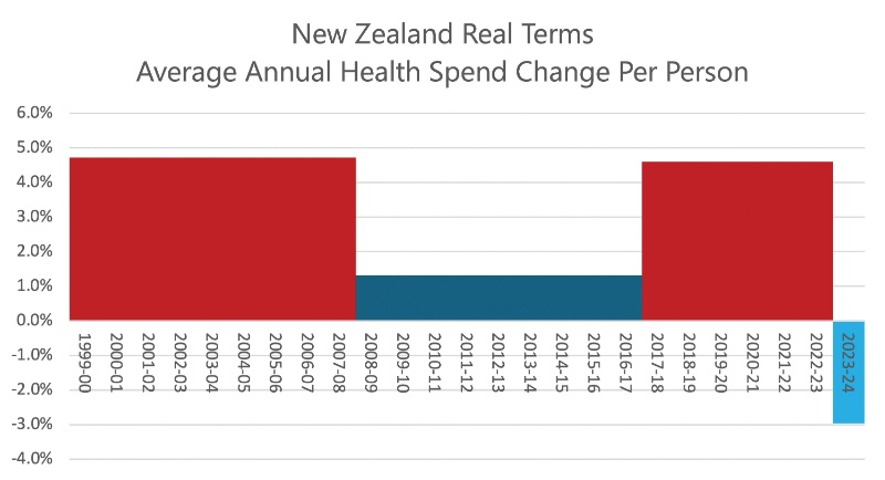 Gordon Campbell: On The Americanising Of NZ’s Public Health System
 Rio Tinto & NZAS: Archaeological Project Underway From Historic Excavations At Tiwai Point
 New Zealand Deerstalkers Association: NZDA Urges Hunters To Prioritise Safety This Roar Season
 PSA: 1000 Days Since Landmark Pay Equity Deal Expired - Workers Losing $145 A Week
 Grace Tinetali-Fiavaai, RNZ: Widow Of Fa'anānā Efeso Collins Seeks Inquiry Into His Death - 'Unanswered Questions'
 Te Pāti Māori: Te Pāti Māori Call For Mandatory Police Body Cameras
 NZ First Party: NZ First Introduces the “Conscience Acts Referendums Bill”