 Scoop has an Ethical Paywall


Landslide Dam Along Tauwhareparae Road Assessed Low-risk
A landslide dam on Tauwhareparae Road has been assessed as low to minimal risk of failure.
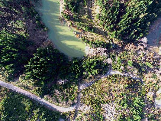
The dam formed after the heavy rain event in June when landslides caused massive damage to the rural road that sits inland between Uawa and Whatatutu.
Gisborne District Council Principal Scientist Dr Murry Cave says the dam of water is being actively monitored and inspected, especially after rain.
“The landslide dam itself is quite small at 1.2Ha, and water is freely flowing through it which reduces risk.
“The gradient on the dam is low, which also reduces the risk of rapid failure.”
Dr Cave says this type of feature is expected to break down gradually over the next few months.
The dam has been assessed as having 26,000 m3 of water in it and measures 5m deep and 20m wide, and is pictured below.
 Gordon Campbell: On The Hikoi Aftermath
 Free Speech Union: Fair Digital News Bargaining Bill Likely To Restrict Access To Information, Polling Shows Most Oppose
 Auckland Transport: Driver Safety Screens Now Rolling Out Across Auckland’s Bus Fleet
 People Against Prisons Aotearoa: 'Expect Resistance' - Community Group Pushes Back Against More Cops With Guns
 Greenpeace: New Zealand Drops In Global Ranking On Climate Action
 PSA: Spending Cuts Need To Stop - PSA Urges Govt To Listen To Economists
 Stats NZ: National Population Estimates: At 30 September 2024 (2018-base)