Wet In The West, East The Place To Be For Matariki
Covering period
of Thursday 13th - Sunday 16th
July
For the final weekend of the school holidays, and the Matariki long weekend, MetService is forecasting an unsettled west to southwest flow over Aotearoa New Zealand. This means cloud and showers for those in the west and south of the country, while eastern regions will have the best chance to get outside and view the Matariki cluster.
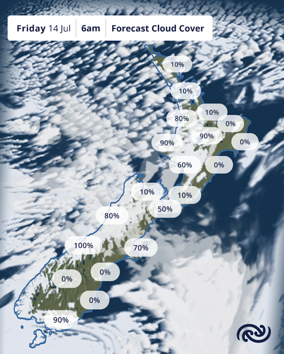
On Friday, cloud and frequent showers are forecast to affect the west and south of the South Island in an unstable southwesterly feed of air, while a cold front is expected to brush the east, bringing scattered cloud and a few showers through Canterbury and Otago. Western regions of the North Island are also expected to see cloud and showers, but further north the cloud and showers become more isolated.
The best time to view the Matariki cluster is the early morning, just before dawn. For those who plan on heading out early Friday morning, the clearest skies are forecast to be in the Bay of Plenty, Gisborne, and Hawke’s Bay. Metservice Meteorologist Amy Loots says, “Further south for Wairarapa, Wellington, Nelson and Marlborough, there may be some patchy high cloud, but chances are still good for some views.”
West to southwest winds are expected to be strong at times throughout the weekend. Strong Wind Watches for Severe Gales are currently in force through to this evening (Thursday) for the Tasman Region and Hawke’s Bay south of State Highway 5. “The strong winds may persist into Friday, and these Watches may be extended or upgraded to a Warning” Loots says.
Looking further into the weekend, eastern regions remain fine, while a few showers continue to affect the west. On Sunday, showers turn to rain in the west and south of the South Island, while another burst of strong westerly winds are expected for central and southern New Zealand. People are advised to stay up to date with their local forecasts and any Severe Weather Warnings and Watches that may be issued.


 Gordon Campbell: On The Hikoi Aftermath
 NZ Government: PM Marks One Year In Government
 Helen Clark Foundation: Helen Clark Foundation Calls For Political Action To Reduce The Prevalence Of Junk Food And Improve Health Outcomes
 Justice Committee: Further Decisions About Submissions Process For The Principles Of The Treaty Of Waitangi Bill
 Infrastructure New Zealand: Single Agency Needed To Coordinate Climate Adaptation And Recovery
 Free Speech Union: Fair Digital News Bargaining Bill Likely To Restrict Access To Information, Polling Shows Most Oppose
 Auckland Transport: Driver Safety Screens Now Rolling Out Across Auckland’s Bus Fleet


