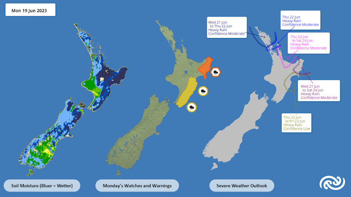
Additional Rain On The Cards For Sodden North Island Areas
Covering period
of Monday 19 - Thursday 22
June
Heavy rainfall for the east coast of the North Island is set to ease for a time, as MetService’s latest round of Severe Weather Warnings is set to expire on Monday. However, the reprieve will be short-lived, as further heavy rain is expected later in the week for the north and east, due to a low pressure system approaching from the Tasman Sea.
MetService meteorologist Alwyn Bakker explains, “A stubborn high to the east of Aotearoa/New Zealand has been keeping weather systems pinned over the country, bringing heavy rain to eastern regions. It's been a rough and wet time the last several months in the northeast of the North Island, and we know this latest spell of wet weather will be hard news to take for some."
Parts of Tairāwhiti/Gisborne recorded over 60mm of rain in the 24 hours from 10am on Sunday, and Gisborne itself saw about 30mm in that period. Further south, a few locations in Hawke’s Bay and the Wairarapa also saw about 30mm. Heavy Rain Warnings and Watches continue for these regions on Monday; an Orange Rain Warning for Tairāwhiti/Gisborne, and the Wairoa District northeast of Nuhaka, runs through until 3pm Monday, while Yellow Heavy Rain Watches for Hawke’s Bay about and south of Te Pohue, and the Wairarapa, including the Tararua District, wrap up later Monday evening.
Tuesday brings a bit of a reprieve as the rain eases off, but showers will still be on the cards for most.
“Southland’s really the place to be on Tuesday, and aside from Taranaki, the western regions of the North Island will also be mainly dry,” advises Bakker. “Elsewhere, there will be some showers hanging about.”
Things are set to get wetter on Wednesday, as a low pressure centre approaching Aotearoa from the Tasman Sea directs moist northeasterlies over the country again. This regime will bring a prolonged period of wet weather to northern and eastern parts of the North Island, especially Coromandel Peninsula, Bay of Plenty and Tairāwhiti/Gisborne.
“The accumulation of rain over several days in these already sodden areas could cause surface flooding and activate slips regardless of whether warning level amounts of rain occur,” cautions Bakker.
“Keep an eye out for Severe Weather Watches and Warnings over at bit.ly/AllWarnings or by checking out our Facebook and Twitter, where we also post our important updates.”


 Gordon Campbell: On Justin Trudeau’s Demise, In A Global Context
 NZCAST: Survivors Of Abuse In Care Left Waiting - Urgent Action Needed Following Apology
 Ōnuku Rūnanga: No One Wants Wastewater In Akaroa Harbour
 NZ Police: Funeral For Senior Sergeant Lyn Fleming Confirmed
 NZ Police: Making Waves On The World Stage
 ACT New Zealand: Too Many Kiwis Denied The Chance To Gather With Loved Ones At The End Of Life
 Lady Tureiti Moxon: Honouring Kahurangi Tariana Turia - A Legacy of Courage, Leadership, and Tino Rangatiratanga


