Prepare Now: Cyclone Gabrielle Could Rival Intensity Of 2018 Storm
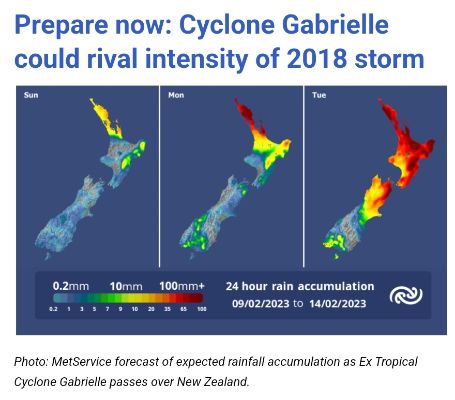
The impact of Ex Tropical Cyclone Gabrielle on the Coromandel is likely to be similar to the 2018 storm and just below the intensity of Cyclone Bola in 1988. For this reason, the State of Emergency has been extended for another week across the Coromandel.

On its current course, Gabrielle will be felt on Sunday afternoon with increasing winds and rain, and this will gradually intensify through Monday before the full force hits on Tuesday morning. It will begin to ease through Wednesday.
Here is what we know already:
- Gale force easterly / northeasterly winds with gusts exceeding 135 km/h.
- Up to 300mm of rain between Monday and Wednesday.
- Storm surge
across both the East and West coasts which will result
in:
- Coastal inundation, across many lower lying areas, which could result in flooding of many beachside/ coastal urban areas.
- Isolation due to flooding and roading network blockages, trees down, power outages.
“Use these next three days to prepare and plan” says our Civil Defence Controller Garry Towler.
“This cyclone, the fifth severe storm we have had since November last year is packing a nasty punch, so for those living or staying in lower lying coastal areas think about and plan for evacuation. For everyone on the Coromandel get ready with supplies to last three days, and above everything else lock in a plan to be somewhere safe and secure by next Monday evening”.
A comprehensive update will be provided on Friday, including where we believe inundation and urban flooding could occur, an update on the cyclone and what support and resources are going to be available.
See our website and Facebook page for local roading conditions. If you see anything on our local roads, let us know on 07 868 0200 or email customer.services@tcdc.co.nz.
For State Highways, keep an eye on their website or contact 0800 4 HIGHWAYS (0800 44 44 49).
Check before you travel with | Thames-Coromandel District Council Facebook | Waka Kotahi/NZTA | MetService


 Gordon Campbell: On The Government’s Latest Ferries Scam
 RNZRSA: RNZRSA Supports Willie Apiata VC's Stand To Drive Change To Veterans’ Support Act
 Diane McCarthy - LDR: War Hero Willie Apiata Entrusts MP With Victoria Cross Medal
 PSA: Disappointing Govt Attack On Diversity, Inclusion In Public Service
 NZ Labour Party: Govt Health And Safety Changes Put Workers At Risk
 Amnesty International Aotearoa New Zealand: Democracy At Risk
 Walk Without Fear Trust: New Sentencing Reforms Aimed At Restoring Public Safety Welcomed


