 Scoop has an Ethical Paywall


Chilly Winds And A Look To The Stars
Covering period
of Monday 20 - Thursday 23
June
It sure is chilly, and MetService is forecasting the cold weather to stick around.
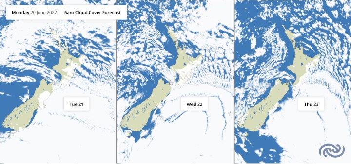
Cold, windy southeasterlies are blowing across the North Island today (Monday). This means it's a good time to make use of the "feels like" temperature that factors in wind chill, found under Current Conditions on metservice.com. MetService meteorologist Dan Corrigan explains, “These blustery conditions are due to the isobars bunching up between high pressure over the South Island and a low pressure system away to the northeast of the country.”
The southeasterly winds are also driving cloudy and showery weather into eastern areas, which may make stargazing tricky at the start of this week. Skies clear up tomorrow in the east of the South Island, then during Thursday further north.
As high pressure spreads northwards, winds ease in the North Island tomorrow, and most places around the country see long stretches of fine weather. Clear and still nights make for frosty mornings, but also favourable viewing conditions for the stars that signify the coming of Te Tau Hou (the Māori New Year).
On Friday morning, northwestern parts of both islands cloud over as the next weather system approaches from the Tasman Sea before rain sets in on the West Coast. “Eastern and southern areas have the best chance of seeing Matariki and Puanga before dawn, and we’ll be providing a cloud cover forecast for Friday morning closer to the time,” says Corrigan. The generally unsettled conditions spread across the country this Matariki long weekend as frontal systems pass over from the west.
 Gordon Campbell: On The Hikoi Aftermath
 Mana Mokopuna: Children And Young People Share Vital Insights On Healing From Family Violence And Sexual Violence In New Report
 NZ Government: PM Marks One Year In Government
 Helen Clark Foundation: Helen Clark Foundation Calls For Political Action To Reduce The Prevalence Of Junk Food And Improve Health Outcomes
 Justice Committee: Further Decisions About Submissions Process For The Principles Of The Treaty Of Waitangi Bill
 Infrastructure New Zealand: Single Agency Needed To Coordinate Climate Adaptation And Recovery
 Free Speech Union: Fair Digital News Bargaining Bill Likely To Restrict Access To Information, Polling Shows Most Oppose