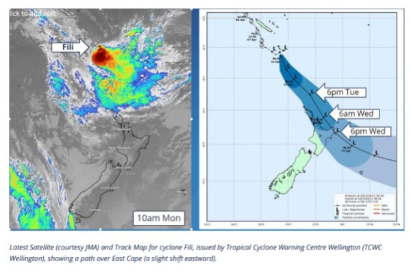
Fili Bears Down On The Coromandel
During the course of the day our Civil Defence Team has had briefings from MetService, Waikato Regional Council and Coastal Scientists to better understand the likely impacts of Ex Tropical Cyclone Fili which is bearing down on the Coromandel.

What we know:
- Fili will begin to develop and be noticeable from late morning Tuesday.
- By 6pm Tuesday evening heavy rain accumulating in 150mm overnight, along with easterly turning to south westerly gale force winds gusting up to 120-130km/h.
- Storm surges are possible, especially at high tide around 3am on Wednesday morning. This may add another 30cm to the high tide level (similar to a Spring/King tide)
What might happen:
- This is a low pressure driven ex tropical cyclone, it will be intense but relatively short lived, passing over Tuesday night and starting to clear late Wednesday morning.
- There is a high possibility that parts of the Coromandel will lose power, trees and slips will block the roading network, some communities will become isolated, some beaches on the East Coast will suffer further erosion.
What we advise:
- Take the time available to prepare - get in supplies to last two days, including batteries, meds, fuel/gas.
- Secure loose items on your property.
- Clear drains and gutters.
- Pause any travel plans on the Coromandel between 7pm Tuesday until daylight Wednesday morning to minimise the risk of hitting debris/trees/slips.
- Stay away from the beaches and streams until the storm has passed, do not venture out on to the water.
- Keep up to date with MetService, Waka Kotahi and our TCDC Facebook page
We will provide a further update tomorrow morning.


 Gordon Campbell: On The Left’s Electability Crisis, And The Abundance Ecotopia
 NZ Police: New Zealand Police team up with Z Energy, NZTA and ACC to remind Kiwis to drive safe this Easter
 NZCAST: NZCAST Leads Ongoing Cross-Agency Collaboration To Break Down Barriers For Survivors Of State Abuse
 Regional and Unitary Councils Aotearoa: Regional And Unitary Councils Back A Practical FWFP System
 NZ Government: Stay Safe On Our Roads This Easter
 YWCA: Global Push Back Against Gender Equality A Growing Crisis In Aotearoa
 Te Pāti Māori: Ngarewa-Packer - Fast-Tracking Seabed Mining Ignores Māori Opposition And Environmental Precedent


