 Scoop has an Ethical Paywall


Dry And Humid In The North, While Concerning Heavy Rain Hits Areas Of The South Island
Covering period of Monday 31st January - Thursday 3rd February
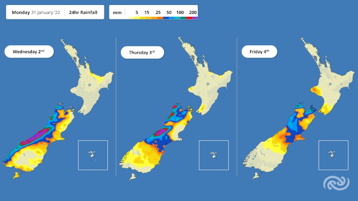
Dry, warm conditions prevail across much of the country early this week, however MetService is forecasting a dramatic change for parts of the South Island with significant rainfall forecast from Wednesday.
A low pressure system is transporting warm tropical air towards the western South Island this week, bringing heavy and prolonged rain which starts spreading from Fiordland to Tasman including the headwaters of Otago and Canterbury from Wednesday.
Heavy rain Watches and Warnings have been issued for this event this (Monday) morning. An Orange Heavy Rain Warning is in place for Westland and Buller, valid from Wednesday, while Fiordland, western Tasman, and the Canterbury and Otago headwaters have been issued a Heavy Rain Watch.
MetService meteorologist Ashlee Parkes explains, “Hokitika and Milford Sound have had their driest January on record since 1963 and 1997 respectively. The month of January and the beginning of February will be quite the contrast.”
MetService are forecasting significant rain accumulations across Westland and Buller during this event, particularly in the ranges. There is the potential that the Westland Orange Warning could be upgraded to a Red Warning in the coming days. Along with Regional Councils and hydrologists, MetService meteorologists will be monitoring the situation closely.
“Heavy rain could cause rivers to rise rapidly, localised surface flooding and slips which when combined with a King Tide could cause hazardous driving conditions. People are strongly advised to keep up to date with the latest Warnings and Watches.” Parkes continues.
The heavy rain is forecast to spread across into the central and eastern South Island, the northern South Island, as well as onto the lower North Island towards the end of the week before becoming slow moving. So although this system brings significant rain relief to many regions, unfortunately those in the northern half of the North Island will see little respite from the dry conditions; one or two light showers may sprinkle the northeastern coast, otherwise the weather remains dry and warm.
Parkes elaborates, “As this low pressure system tracks towards the South Island, warm northeasterly winds strengthen across Aotearoa. Many will also notice the humidity rise over the coming days as this system drags muggy, tropical air across the country.”
“We have some heat alerts in place across the country during the first half of this week as many regions see their maximum daily temperature push into the late 20s and early 30s, with little relief overnight. On Wednesday and Thursday, Nelson has only a one-degree difference between its daily high temperature of 22°C, and an overnight low of 21°C,” says Parkes.
 Gordon Campbell: On What’s Wrong With The Treaty Principles Bill
 Mana Mokopuna: Children And Young People Share Vital Insights On Healing From Family Violence And Sexual Violence In New Report
 NZ Government: PM Marks One Year In Government
 Helen Clark Foundation: Helen Clark Foundation Calls For Political Action To Reduce The Prevalence Of Junk Food And Improve Health Outcomes
 Justice Committee: Further Decisions About Submissions Process For The Principles Of The Treaty Of Waitangi Bill
 Infrastructure New Zealand: Single Agency Needed To Coordinate Climate Adaptation And Recovery
 Free Speech Union: Fair Digital News Bargaining Bill Likely To Restrict Access To Information, Polling Shows Most Oppose